PRELIMINARY RELEASE
available as a zipped pdf file for downloading from here
1 – BASIC TOOLS
1
– 1 Using the nature of the objects
1 – 2 Using the geographical definition of the objects
1 – 3 Using the contents of the objects
1 – 4 Using the style of the objects
2 –
Geographic operators and two-objects functions
2 – 1 Operators available for a selection
2 – 2 The “second” object
2 – 3 Two-objects geographic functions
This document explores ways to use objects own characteristics in selections. “Own characteristics” exclude tabular data and limit this search to the nature of the objects, their geographical definitions, their contents and their styles. It is not intended to be a guide to SQL expression writing but to show how these special features of a GIS program can be used in a “where” expression.
MapInfo does not allow comparing two objects directly and globally; an expression in a selection like “Object1=Object2” will not be accepted. Comparisons can only be made on specific elements of their definition. A possible difference between two objects can be more easily proven than a perfect identity. For details on that subject, see the “Identity.doc” document distributed with the SkimAll application (PPCC site, Services and Products).
As the MI requesters share the same working space as the MapBasic window, the variables defined in the MBWindow are directly available to the requesters. All the “where” conditions presented in this document can be used indifferently in the SQL requester or as part of full Select statement in the MBWindow.
1 - Basic tools
1 – 1 Using the nature of the objects
We are dealing here essentially with object types that are limited. The following list gives the exact spelling of the names and their numerical code:
| Arc | 1 |
| Ellipse | 2 |
| Line | 3 |
| Polyline | 4 |
| Point | 5 |
| Frame | 6 |
| Region | 7 |
| Rectangle | 8 |
| Rounded Rectangle | 9 |
| Text | 10 |
From the MapBasic window or from a MI requester, object type can be determined in two different ways: by calling the ObjectInfo() function or by querying obj directly. In both cases, a comparison between a function that can take multiple forms (string, smallint, logical, float…) or obj that is a “form” in itself and another term (string or smallint) will not be accepted without having forced both terms of the comparison to be of the same type. The standard way to handle this is to use the Str$() function on the left side and to enclose the right part between double quote signs.
The general ways to write the alternative equalities are
1 – 2 Using the geographical definition of the objects
Geographical definition includes information of different nature. They include data on the structure of the object
number of sections of a polyline or of polygons in a region. Using the formula
number of nodes in a polyline or in an object. If we use
length of a linear object
ObjectLen(obj, ”m”)>1000 length of the border of a closed object
selects all the linear objects with a length over 1000 meters.
Perimeter(obj, ”km”)<1000 area of a closed object
picks up all regions with perimeters inferior to 1000 km.
Area(obj, ”sq mi”)>0
is a way to select all closed objects
on its absolute position by the coordinates of
a point object
the centroid of any type of object
the beginning and ending nodes of a line
the opposite corners of the MBR of any object
1 – 3 Using the contents of the objects
The only type of objects that has some real contents is Text, and its contents are the text string itself. Selection can be made with
1 – 4 Using the style of the objects
Global style clause
The values returned by ObjectInfo() for style parameters are in the form of a style clause, such as “Pen(1,2,0)”. If the selection is made on a complete style, the second part of the expression must be also a complete style definition. To achieve this requirement, the reference can be a string variable or a style variable. One must make also sure that both sides of the expression are of the same type.
String variable in Mapasic window
Dim String_Var as string
String_Var=”Pen(1,3,0)”
Selection “where”
Str$(ObjectInfo(obj,2))=String_Var
Style variable in MapBasic window
Dim Style_Var as pen
Style_Var=MakePen(1,3,0)
Selection “where”
Str$(ObjectInfo(obj,2))=Str$(Style_Var)
Note: the string or the style variable can be “filled” in different ways, such as
St…_Var=currentpen()
St…_Var=objectinfo(selection.obj,2)
Single style element
Several single style elements can be used independently. We have to deal with the fact that the value of the argument of the function used to extract a style element may be different for the various types of styles. Let us recap first those parameters:
| Brush | Pen | Font | Symbol | |
| Pattern | 1 | 2 | ||
| Pointsize | 3 | 3 | ||
| Color | 4 | 2 | ||
| forecolor | 2 | 4 | ||
| backcolor | 3 | 5 | ||
| Font name | 1 | |||
| … style | 2 | |||
| Pen width | 1 | |||
| … interleaved | 6 | |||
| … index | 5 | |||
| Symbol kind | 7 | |||
| … code | 1 | |||
| … font_name | 5 | |||
| … font_style | 6 | |||
| … angle | 4 | |||
| … custom_name | 8 | |||
| … custom_style | 9 |
Single element selections must thus be made on sets of objects of the same type to avoid any possible confusion. It is not possible for example to select in one operation all the “red” objects in a table containing several types.
2 – Geographic operators and two-objects functions
2 – 1 Operators available for a selection
These are the standard MI operators that take into account the relative geographic definitions of the objects. There are 3 families, Contains (Contains, Contains Part, Contains Entire), Within (Within, Partly Within, Entirely Within) and Intersects.
I will not elaborate on MI description and example of those key words. I will simply insist on some points.
From the basic definition of these operators, it is obvious that they cannot be applied to every kind of objects without limitations. Let us summarize the kind of operators logically useable in the general expression “obj oper objectA” (the second one being the reference) and which objects are selected.
Only situations that were found as producing a non-empty selection are detailed in the following table; we have found no way to fill a selection if the reference is a text object.
| Reference object | |||
| Map object | Symbol | Linear object | Closed object |
| Symbol | I All symbols at same location | (*1) | C Part, W (*3), I All symbols located within ref. |
| Text | I All texts with MBR containing ref. | I All texts with MBR bisected by ref. | C Part, Partly W, I All texts with MBR bisected by ref. W All texts with MBR centroid within ref. Entirely W All texts entirely within ref. |
| Linear object | (*1) | I All objects bisected by ref. | C Part, Partly W, I All objects bisected by ref. W All objects with centroid within ref. Entirely W All objects entirely within ref. |
| Closed object | C (*2), I All objects containing the point | C Part, Partly W, I All objects bisected by ref. C All objects containing the centroid of ref. C Entire All objects containing entirely ref. | C All objects containing the centroid of ref. C Entire All objects containing entirely ref, C Part All objects that bisect ref. W All objects with centroid within ref. Entirely W All objects entirely within ref. Partly W, I All objects bisected by ref. |
2 – 2 The “second” object
One object in a comparison is the “column” obj, and we know that it cannot be it for the second one. We have seen that it must be defined outside the command containing such expressions. We will use the MapBasic window to define it. For example, one way of doing it is to select the object then do the following
MapBasic window commands
2 – 3 Two-objects geographic functions
There are several functions that require two objects as argument and return some information concerning their relative geographical structures. For example:
We have designated the objects O1 and O2; these names must be replaced by obj and O in the appropriate order as it applies.
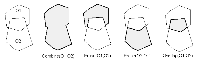
| Function | Return value | Typical use in selection |
| AreaOverlap(O1,O2) | Surface of the common area to both objects in current area units | Regions overlapping by a set amount |
| ProportionOverlap(O1,O2) | Proportion of area of overlap (O1,O2) relative to area of O1 | Regions overlapping by a set proportion of O1. |
| OverlayNodes(O1,O2) | Object with all the nodes of O1 plus nodes where O2 intersects O1 | Used in conjunction with ObjectInfo(obj,20) to detect change in the number of nodes. |
| Combine(O1,O2) | Object as the union of O1 and O2 | Used in conjunction with some other function (area, length..) to compare to set values, or with ObjectInfo(obj,21) to find if objects merged or remained separate sections/polygons. |
| Erase(O1,O2) | Object left when O1 is erased by O2 | Used in conjunction with other functions such as area() |
| Overlap(O1,O2) | Object as the intersection of O1 and O2 | Used in conjunction with other functions such as area() |
| Buffer(O,resol,width,”unit”) | Object as the buffer of O | Used in “proximity” selection with geographic operators |
3 – Some examples
3 – 1 How to eliminate the “constant” object from the selection
If the object serving of reference is in the table on which the selection is applied, (e.g. by using in the MapBasic window O=selection.obj and making that variable the right side of the expression), it is included in the selection, and be sometimes the only selection. If we do not want it, then we must add an extra condition to exclude it. We can do that if we know the rowid of that object by adding to the where condition “ and rowid<>row_of_object”.
The MB script would thus be:
Dim O as object
Dim i_row as integer
O = selection.obj
i_row=commandinfo(2)
and the where expression:
Obj intersects O and rowid<>i_row
That condition creates a selection of all the objects intersecting O, excluding O itself
3 – 2 How to eliminate selected not-really-intersecting regions
If we do not want to include in a selection obtained by a “Contains Part”, “Partially Within” or “Intersects” operator those regions that touches to the reference objects but do not really overlap it, we can add to the “where” expression and extra condition that will check for eventual false overlaps. We can use the AreaOverlap() function for that.
Remember also that if object A is totally within object B, it is considered as intersected by B. Excluding “internal” objects would require an extra condition such as “and not obj entirely within O” and to be complete for sake of symmetry “and not obj contains entire O”. The following statement will only select those regions that overlap in part the reference object or are overlapped in part by it.
Obj intersects O and rowid<>i_row and AreaOverlap(obj,O)>0
and not obj entirely within O and not obj contains entire O
3 – 3 How to select all “red” objects in a mixed table
One must take into consideration that the color is defined in different “clauses” obtained differently for different types of objects and that color must be extracted with a special function from those clauses. To cover all eventualities, the where expression should contain all the following parts
Note 1 - We use “r_col” (integer) to ferry the “red” color rather that the rgb value for red to get a more general expression
Dim r_col as integer
r_col=255
Note 2 – Some objects have more than one color: regions have two, fill and border, sometimes 3 when the pattern has fore and back color; text may have two in some cases with fore and back color. We will use only the forecolor for regions and texts. If the others were required, extra parts should be added to the expression.
Note 3 – We have not included “Frame” because it is not found in a map.
where expression
Str$(obj)=”Arc” and StryleAttr(ObjectInfo(obj,2) or
Str$(obj)=”Ellipse” and StryleAttr(ObjectInfo(obj,3) or
Str$(obj)=”Line” and StryleAttr(ObjectInfo(obj,2) or
Str$(obj)=”Polyline” and StryleAttr(ObjectInfo(obj,2) or
Str$(obj)=”Point” and StryleAttr(ObjectInfo(obj,2) or
Str$(obj)=”Region” and StryleAttr(ObjectInfo(obj,3) or
Str$(obj)=”Rectangle” and StryleAttr(ObjectInfo(obj,3) or
Str$(obj)=”Rounded Rectangle” and StryleAttr(ObjectInfo(obj,3) or
Str$(obj)=”Text” and StryleAttr(ObjectInfo(obj,4)
= r_col
3 – 4 How to select all “paths” getting closer than a given distance from an object.
The “paths” are continuous polylines stored in table “paths”. The object is a region made into the variable object O from another table. We want to know all the paths that do not intersect the object but are getting closer than a given distance DistMini expressed in “distance units”
The “do not intersect” is translated by the negation of an intersection and the betting closer by an intersection with the region inflated (bufferd) by DistMini
not obj intersects O and obj intersects Buffer(O,20, DistMini, “distance unit”)