Nous utilisons des cookies pour vous garantir la meilleure expérience sur notre site. Si vous continuez à utiliser ce dernier, nous considèrerons que vous acceptez l'utilisation des cookies. J'ai compris ! ou En savoir plus !.
banniere

Le portail francophone de la géomatique


Toujours pas inscrit ? Mot de passe oublié ?

Ceci est une ancienne révision du document !


Strict Standards: Declaration of syntax_plugin_tag_topic::handle() should be compatible with DokuWiki_Syntax_Plugin::handle($match, $state, $pos, Doku_Handler $handler) in /var/www/html/web/wiki/lib/plugins/tag/syntax/topic.php on line 123

Strict Standards: Declaration of syntax_plugin_tag_topic::render() should be compatible with DokuWiki_Syntax_Plugin::render($format, Doku_Renderer $renderer, $data) in /var/www/html/web/wiki/lib/plugins/tag/syntax/topic.php on line 123

Strict Standards: Declaration of syntax_plugin_tag_searchtags::handle() should be compatible with DokuWiki_Syntax_Plugin::handle($match, $state, $pos, Doku_Handler $handler) in /var/www/html/web/wiki/lib/plugins/tag/syntax/searchtags.php on line 280

Strict Standards: Declaration of syntax_plugin_tag_searchtags::render() should be compatible with DokuWiki_Syntax_Plugin::render($format, Doku_Renderer $renderer, $data) in /var/www/html/web/wiki/lib/plugins/tag/syntax/searchtags.php on line 280

Strict Standards: Declaration of syntax_plugin_tag_tag::handle() should be compatible with DokuWiki_Syntax_Plugin::handle($match, $state, $pos, Doku_Handler $handler) in /var/www/html/web/wiki/lib/plugins/tag/syntax/tag.php on line 118

Strict Standards: Declaration of syntax_plugin_tag_tag::render() should be compatible with DokuWiki_Syntax_Plugin::render($format, Doku_Renderer $renderer, $data) in /var/www/html/web/wiki/lib/plugins/tag/syntax/tag.php on line 118

Strict Standards: Declaration of syntax_plugin_tag_count::handle() should be compatible with DokuWiki_Syntax_Plugin::handle($match, $state, $pos, Doku_Handler $handler) in /var/www/html/web/wiki/lib/plugins/tag/syntax/count.php on line 130

Strict Standards: Declaration of syntax_plugin_tag_count::render() should be compatible with DokuWiki_Syntax_Plugin::render($format, Doku_Renderer $renderer, $data) in /var/www/html/web/wiki/lib/plugins/tag/syntax/count.php on line 130

Strict Standards: Declaration of syntax_plugin_tag_tagpage::handle() should be compatible with DokuWiki_Syntax_Plugin::handle($match, $state, $pos, Doku_Handler $handler) in /var/www/html/web/wiki/lib/plugins/tag/syntax/tagpage.php on line 96

Strict Standards: Declaration of syntax_plugin_tag_tagpage::render() should be compatible with DokuWiki_Syntax_Plugin::render($format, Doku_Renderer $renderer, $data) in /var/www/html/web/wiki/lib/plugins/tag/syntax/tagpage.php on line 96

Strict Standards: Declaration of syntax_plugin_clearfloat::handle() should be compatible with DokuWiki_Syntax_Plugin::handle($match, $state, $pos, Doku_Handler $handler) in /var/www/html/web/wiki/lib/plugins/clearfloat/syntax.php on line 74

Strict Standards: Declaration of syntax_plugin_clearfloat::render() should be compatible with DokuWiki_Syntax_Plugin::render($format, Doku_Renderer $renderer, $data) in /var/www/html/web/wiki/lib/plugins/clearfloat/syntax.php on line 74

Strict Standards: Declaration of syntax_plugin_pageindex::handle() should be compatible with DokuWiki_Syntax_Plugin::handle($match, $state, $pos, Doku_Handler $handler) in /var/www/html/web/wiki/lib/plugins/pageindex/syntax.php on line 187

Strict Standards: Declaration of syntax_plugin_pageindex::render() should be compatible with DokuWiki_Syntax_Plugin::render($format, Doku_Renderer $renderer, $data) in /var/www/html/web/wiki/lib/plugins/pageindex/syntax.php on line 187

Strict Standards: Declaration of syntax_plugin_googlemaps_googlemap::handle() should be compatible with DokuWiki_Syntax_Plugin::handle($match, $state, $pos, Doku_Handler $handler) in /var/www/html/web/wiki/lib/plugins/googlemaps/syntax/googlemap.php on line 169

Strict Standards: Declaration of syntax_plugin_googlemaps_googlemap::render() should be compatible with DokuWiki_Syntax_Plugin::render($format, Doku_Renderer $renderer, $data) in /var/www/html/web/wiki/lib/plugins/googlemaps/syntax/googlemap.php on line 169

Strict Standards: Declaration of syntax_plugin_nextpage::handle() should be compatible with DokuWiki_Syntax_Plugin::handle($match, $state, $pos, Doku_Handler $handler) in /var/www/html/web/wiki/lib/plugins/nextpage/syntax.php on line 69

Strict Standards: Declaration of syntax_plugin_nextpage::render() should be compatible with DokuWiki_Syntax_Plugin::render($format, Doku_Renderer $renderer, $data) in /var/www/html/web/wiki/lib/plugins/nextpage/syntax.php on line 69

Strict Standards: Declaration of syntax_plugin_include::handle() should be compatible with DokuWiki_Syntax_Plugin::handle($match, $state, $pos, Doku_Handler $handler) in /var/www/html/web/wiki/lib/plugins/include/syntax.php on line 137

Strict Standards: Declaration of syntax_plugin_include::render() should be compatible with DokuWiki_Syntax_Plugin::render($format, Doku_Renderer $renderer, $data) in /var/www/html/web/wiki/lib/plugins/include/syntax.php on line 137
Plugin installed incorrectly. Rename plugin directory 'backlinks.old' to 'backlinks'.

Création d’une table (ou couche)

La création d’une table doit être précédée d’une étape de réflexion sur la modélisation du phénomène à intégrer dans le SIG. Il s’agit d’un aspect fondamental qui permettra une utilisation rationnelle et aisée du SIG. Une étape à ne pas négliger !

Une collection d’objets de même type sémantique correspond à une table (c’est à dire une “couche”, terme commun utilisé plus classiquement par les autres SIG).
Tous les objets d’une même table doivent être du même type géographique (point, ligne ou polygone).
MapInfo n’interdit pas le mélange d’objets d’implantation différente. Il faut donc porter une attention particulière à la saisie des objets géographiques.

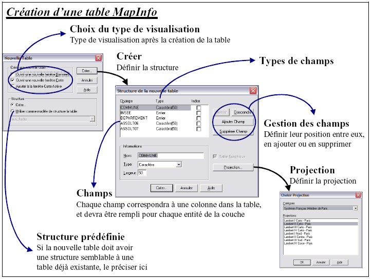
Chaque objet géographique stocké dans une table MapInfo est doté d’un certain nombre d’attributs (ou champs), qui sont définis lors de la création, ou de la modification, de la structure de la table.
MapInfo gère différents types d’attributs : caractère, entier, entier court, flottant, virgule fixe, date, logique.
A partir du menu Fichier, vous pouvez Créer une nouvelle table et accéder à la boîte de dialogue Structure de la nouvelle table.

A partir de la fenêtre Structure de la nouvelle table vous pouvez créer et gérer les champs. Avant de les créer, n’oubliez pas de choisir le système de projection de la table (« systèmes Français méridien de paris » et « Lambert II carto » si vous travaillez sur la France).
Enregistrez votre table dans votre dossier de travail à l’aide du bouton Créer.
Une fois la table créée, elle ne comporte aucun enregistrement ; si vous avez choisi de l’ouvrir dans une fenêtre carte, une fenêtre vide apparaît, mais la couche est présente et modifiable. Ouvrez le contrôle des couches du menu carte (fiche contrôle des couches si besoin) pour le vérifier ou modifier cet état.

 
main/logiciels/mapinfo/documents/creation_d_une_table_ou_couche.1244727529.txt.gz · Dernière modification: 2009/06/11 15:38 par geomatikfab
Recent changes RSS feed Creative Commons License Valid XHTML 1.0 Valid CSS Driven by DokuWiki