banniere

Le portail francophone de la géomatique


Toujours pas inscrit ? Mot de passe oublié ?

Ceci est une ancienne révision du document !


Strict Standards: Declaration of syntax_plugin_googlemaps_googlemap::handle() should be compatible with DokuWiki_Syntax_Plugin::handle($match, $state, $pos, Doku_Handler $handler) in /var/www/html/web/wiki/lib/plugins/googlemaps/syntax/googlemap.php on line 169

Strict Standards: Declaration of syntax_plugin_googlemaps_googlemap::render() should be compatible with DokuWiki_Syntax_Plugin::render($format, Doku_Renderer $renderer, $data) in /var/www/html/web/wiki/lib/plugins/googlemaps/syntax/googlemap.php on line 169

Strict Standards: Declaration of syntax_plugin_nextpage::handle() should be compatible with DokuWiki_Syntax_Plugin::handle($match, $state, $pos, Doku_Handler $handler) in /var/www/html/web/wiki/lib/plugins/nextpage/syntax.php on line 69

Strict Standards: Declaration of syntax_plugin_nextpage::render() should be compatible with DokuWiki_Syntax_Plugin::render($format, Doku_Renderer $renderer, $data) in /var/www/html/web/wiki/lib/plugins/nextpage/syntax.php on line 69

Strict Standards: Declaration of syntax_plugin_pageindex::handle() should be compatible with DokuWiki_Syntax_Plugin::handle($match, $state, $pos, Doku_Handler $handler) in /var/www/html/web/wiki/lib/plugins/pageindex/syntax.php on line 177

Strict Standards: Declaration of syntax_plugin_pageindex::render() should be compatible with DokuWiki_Syntax_Plugin::render($format, Doku_Renderer $renderer, $data) in /var/www/html/web/wiki/lib/plugins/pageindex/syntax.php on line 177

Requête attributaire simple

La requête attributaire simple se fait sur une seule couche (ou table) et sur un ou plusieurs attributs de cette couche.
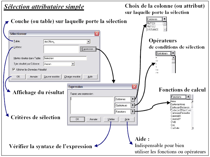
A partir du menu Sélection >Sélection, une fenêtre de sélection s’ouvre, il suffit de choisir la table sur laquelle s’effectuera la sélection (champ table). Les critères de sélections sont les modalités de la sélection.
Dans la fenêtre critères, vous pouvez faire appel à une expression ; seules les valeurs des modalités sont à entrer manuellement, les autres paramètres de modalités sont à choisir avec les ascenseurs.

NB : les valeurs limites de sélection qui correspondent à des chaînes de caractères sont à saisir entre guillemets (“ ”). Il est donc important d’observer la table attributaire ou la structure de la table avant de faire une sélection.

Exemple : sélectionner toutes les provinces de plus de 1000 km² (attribut « Sqkm ») de France (attribut « Cntryname ») dans la ‘couche prov3_eu’ affichée ci-dessous :

Table : prov3_eu (à choisir avec l’ascenseur)
Critères >Expression : Cntryname = “France” And Sqkm >= 1000
Seuls « France » et 1000 sont à entrer manuellement, Cntryname et Sqkm sont à sélectionner dans le menu Colonnes, =, >= et And dans le menu déroulant Opérateurs.

 
main/logiciels/mapinfo/documents/requete_attributaire_simple.1245141598.txt.gz · Dernière modification: 2009/06/16 10:39 par geomatikfab
Recent changes RSS feed Creative Commons License Valid XHTML 1.0 Valid CSS Driven by DokuWiki