Nous utilisons des cookies pour vous garantir la meilleure expérience sur notre site. Si vous continuez à utiliser ce dernier, nous considèrerons que vous acceptez l'utilisation des cookies. J'ai compris ! ou En savoir plus !.
banniere

Le portail francophone de la géomatique


Toujours pas inscrit ? Mot de passe oublié ?

Ceci est une ancienne révision du document !


Strict Standards: Declaration of syntax_plugin_tag_topic::handle() should be compatible with DokuWiki_Syntax_Plugin::handle($match, $state, $pos, Doku_Handler $handler) in /var/www/html/web/wiki/lib/plugins/tag/syntax/topic.php on line 123

Strict Standards: Declaration of syntax_plugin_tag_topic::render() should be compatible with DokuWiki_Syntax_Plugin::render($format, Doku_Renderer $renderer, $data) in /var/www/html/web/wiki/lib/plugins/tag/syntax/topic.php on line 123

Strict Standards: Declaration of syntax_plugin_tag_searchtags::handle() should be compatible with DokuWiki_Syntax_Plugin::handle($match, $state, $pos, Doku_Handler $handler) in /var/www/html/web/wiki/lib/plugins/tag/syntax/searchtags.php on line 280

Strict Standards: Declaration of syntax_plugin_tag_searchtags::render() should be compatible with DokuWiki_Syntax_Plugin::render($format, Doku_Renderer $renderer, $data) in /var/www/html/web/wiki/lib/plugins/tag/syntax/searchtags.php on line 280

Strict Standards: Declaration of syntax_plugin_tag_tag::handle() should be compatible with DokuWiki_Syntax_Plugin::handle($match, $state, $pos, Doku_Handler $handler) in /var/www/html/web/wiki/lib/plugins/tag/syntax/tag.php on line 118

Strict Standards: Declaration of syntax_plugin_tag_tag::render() should be compatible with DokuWiki_Syntax_Plugin::render($format, Doku_Renderer $renderer, $data) in /var/www/html/web/wiki/lib/plugins/tag/syntax/tag.php on line 118

Strict Standards: Declaration of syntax_plugin_tag_count::handle() should be compatible with DokuWiki_Syntax_Plugin::handle($match, $state, $pos, Doku_Handler $handler) in /var/www/html/web/wiki/lib/plugins/tag/syntax/count.php on line 130

Strict Standards: Declaration of syntax_plugin_tag_count::render() should be compatible with DokuWiki_Syntax_Plugin::render($format, Doku_Renderer $renderer, $data) in /var/www/html/web/wiki/lib/plugins/tag/syntax/count.php on line 130

Strict Standards: Declaration of syntax_plugin_tag_tagpage::handle() should be compatible with DokuWiki_Syntax_Plugin::handle($match, $state, $pos, Doku_Handler $handler) in /var/www/html/web/wiki/lib/plugins/tag/syntax/tagpage.php on line 96

Strict Standards: Declaration of syntax_plugin_tag_tagpage::render() should be compatible with DokuWiki_Syntax_Plugin::render($format, Doku_Renderer $renderer, $data) in /var/www/html/web/wiki/lib/plugins/tag/syntax/tagpage.php on line 96

Strict Standards: Declaration of syntax_plugin_clearfloat::handle() should be compatible with DokuWiki_Syntax_Plugin::handle($match, $state, $pos, Doku_Handler $handler) in /var/www/html/web/wiki/lib/plugins/clearfloat/syntax.php on line 74

Strict Standards: Declaration of syntax_plugin_clearfloat::render() should be compatible with DokuWiki_Syntax_Plugin::render($format, Doku_Renderer $renderer, $data) in /var/www/html/web/wiki/lib/plugins/clearfloat/syntax.php on line 74

Strict Standards: Declaration of syntax_plugin_pageindex::handle() should be compatible with DokuWiki_Syntax_Plugin::handle($match, $state, $pos, Doku_Handler $handler) in /var/www/html/web/wiki/lib/plugins/pageindex/syntax.php on line 187

Strict Standards: Declaration of syntax_plugin_pageindex::render() should be compatible with DokuWiki_Syntax_Plugin::render($format, Doku_Renderer $renderer, $data) in /var/www/html/web/wiki/lib/plugins/pageindex/syntax.php on line 187

Strict Standards: Declaration of syntax_plugin_googlemaps_googlemap::handle() should be compatible with DokuWiki_Syntax_Plugin::handle($match, $state, $pos, Doku_Handler $handler) in /var/www/html/web/wiki/lib/plugins/googlemaps/syntax/googlemap.php on line 169

Strict Standards: Declaration of syntax_plugin_googlemaps_googlemap::render() should be compatible with DokuWiki_Syntax_Plugin::render($format, Doku_Renderer $renderer, $data) in /var/www/html/web/wiki/lib/plugins/googlemaps/syntax/googlemap.php on line 169

Strict Standards: Declaration of syntax_plugin_nextpage::handle() should be compatible with DokuWiki_Syntax_Plugin::handle($match, $state, $pos, Doku_Handler $handler) in /var/www/html/web/wiki/lib/plugins/nextpage/syntax.php on line 69

Strict Standards: Declaration of syntax_plugin_nextpage::render() should be compatible with DokuWiki_Syntax_Plugin::render($format, Doku_Renderer $renderer, $data) in /var/www/html/web/wiki/lib/plugins/nextpage/syntax.php on line 69

Strict Standards: Declaration of syntax_plugin_include::handle() should be compatible with DokuWiki_Syntax_Plugin::handle($match, $state, $pos, Doku_Handler $handler) in /var/www/html/web/wiki/lib/plugins/include/syntax.php on line 137

Strict Standards: Declaration of syntax_plugin_include::render() should be compatible with DokuWiki_Syntax_Plugin::render($format, Doku_Renderer $renderer, $data) in /var/www/html/web/wiki/lib/plugins/include/syntax.php on line 137
Plugin installed incorrectly. Rename plugin directory 'backlinks.old' to 'backlinks'.

Gestion visuelle des tables (contrôle des couches)

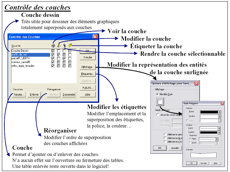
Le contrôle des couches, accessible dans le menu Carte, permet la visualisation et l’apparence des couches de la fenêtre Carte active.

Une couche peut être affichée ou non dans la fenêtre Carte , modifiée (une seule couche à la fois) , sélectionnable (ses objets peuvent être sélectionnés) et étiquetée (ses objets peuvent être étiquetés).
Les cases grisées sont les choix non modifiables pour l’action courante.
L’affichage des entités peut être modifié par le bouton Affichage, mais la modification apportée est uniquement visuelle. La modification n’est pas enregistrée dans la table.

Le contrôle des couches permet de retirer une couche (Ajouter et Enlever), de réorganiser la superposition de celle-ci (Monter et Descendre).
Pour des raisons de lisibilité, les couches ponctuelles superposent les couches linéaires qui superposent les couches polygonales.

La couche dessin permet de rajouter des éléments sur la carte, éléments qui doivent suivre les déplacements de la carte lorsqu’on déplace cette carte dans la mise en page. On peut y mélanger les objets géographiques, puisque ce n’est pas une table (pas de table attributaire associée). Attention : Cette ‘couche’ n’est pas enregistrée ! Pour enregistrer la couche dessin, allez dans le menu Carte >Enregistrer Couche dessin.

Pour que l’action affichage ou étiquette des boutons correspondants concerne bien la table désirée, assurez-vous que le nom de cette table soit bien surligné en bleu dans le contrôle des couches.

Remarque : l’apparence des objets sélectionnés est différente selon que la couche est modifiable ou non.

 
main/logiciels/mapinfo/documents/gestion_visuelle_des_tables_controle_des_couches.1244726093.txt.gz · Dernière modification: 2009/06/11 15:14 par geomatikfab
Recent changes RSS feed Creative Commons License Valid XHTML 1.0 Valid CSS Driven by DokuWiki