Ceci est une ancienne révision du document !
Strict Standards: Declaration of syntax_plugin_tag_topic::handle() should be compatible with DokuWiki_Syntax_Plugin::handle($match, $state, $pos, Doku_Handler $handler) in /var/www/html/web/wiki/lib/plugins/tag/syntax/topic.php on line 123
Strict Standards: Declaration of syntax_plugin_tag_topic::render() should be compatible with DokuWiki_Syntax_Plugin::render($format, Doku_Renderer $renderer, $data) in /var/www/html/web/wiki/lib/plugins/tag/syntax/topic.php on line 123
Strict Standards: Declaration of syntax_plugin_tag_searchtags::handle() should be compatible with DokuWiki_Syntax_Plugin::handle($match, $state, $pos, Doku_Handler $handler) in /var/www/html/web/wiki/lib/plugins/tag/syntax/searchtags.php on line 280
Strict Standards: Declaration of syntax_plugin_tag_searchtags::render() should be compatible with DokuWiki_Syntax_Plugin::render($format, Doku_Renderer $renderer, $data) in /var/www/html/web/wiki/lib/plugins/tag/syntax/searchtags.php on line 280
Strict Standards: Declaration of syntax_plugin_tag_tag::handle() should be compatible with DokuWiki_Syntax_Plugin::handle($match, $state, $pos, Doku_Handler $handler) in /var/www/html/web/wiki/lib/plugins/tag/syntax/tag.php on line 118
Strict Standards: Declaration of syntax_plugin_tag_tag::render() should be compatible with DokuWiki_Syntax_Plugin::render($format, Doku_Renderer $renderer, $data) in /var/www/html/web/wiki/lib/plugins/tag/syntax/tag.php on line 118
Strict Standards: Declaration of syntax_plugin_tag_count::handle() should be compatible with DokuWiki_Syntax_Plugin::handle($match, $state, $pos, Doku_Handler $handler) in /var/www/html/web/wiki/lib/plugins/tag/syntax/count.php on line 130
Strict Standards: Declaration of syntax_plugin_tag_count::render() should be compatible with DokuWiki_Syntax_Plugin::render($format, Doku_Renderer $renderer, $data) in /var/www/html/web/wiki/lib/plugins/tag/syntax/count.php on line 130
Strict Standards: Declaration of syntax_plugin_tag_tagpage::handle() should be compatible with DokuWiki_Syntax_Plugin::handle($match, $state, $pos, Doku_Handler $handler) in /var/www/html/web/wiki/lib/plugins/tag/syntax/tagpage.php on line 96
Strict Standards: Declaration of syntax_plugin_tag_tagpage::render() should be compatible with DokuWiki_Syntax_Plugin::render($format, Doku_Renderer $renderer, $data) in /var/www/html/web/wiki/lib/plugins/tag/syntax/tagpage.php on line 96
Strict Standards: Declaration of syntax_plugin_clearfloat::handle() should be compatible with DokuWiki_Syntax_Plugin::handle($match, $state, $pos, Doku_Handler $handler) in /var/www/html/web/wiki/lib/plugins/clearfloat/syntax.php on line 74
Strict Standards: Declaration of syntax_plugin_clearfloat::render() should be compatible with DokuWiki_Syntax_Plugin::render($format, Doku_Renderer $renderer, $data) in /var/www/html/web/wiki/lib/plugins/clearfloat/syntax.php on line 74
Strict Standards: Declaration of syntax_plugin_pageindex::handle() should be compatible with DokuWiki_Syntax_Plugin::handle($match, $state, $pos, Doku_Handler $handler) in /var/www/html/web/wiki/lib/plugins/pageindex/syntax.php on line 187
Strict Standards: Declaration of syntax_plugin_pageindex::render() should be compatible with DokuWiki_Syntax_Plugin::render($format, Doku_Renderer $renderer, $data) in /var/www/html/web/wiki/lib/plugins/pageindex/syntax.php on line 187
Strict Standards: Declaration of syntax_plugin_googlemaps_googlemap::handle() should be compatible with DokuWiki_Syntax_Plugin::handle($match, $state, $pos, Doku_Handler $handler) in /var/www/html/web/wiki/lib/plugins/googlemaps/syntax/googlemap.php on line 169
Strict Standards: Declaration of syntax_plugin_googlemaps_googlemap::render() should be compatible with DokuWiki_Syntax_Plugin::render($format, Doku_Renderer $renderer, $data) in /var/www/html/web/wiki/lib/plugins/googlemaps/syntax/googlemap.php on line 169
Strict Standards: Declaration of syntax_plugin_nextpage::handle() should be compatible with DokuWiki_Syntax_Plugin::handle($match, $state, $pos, Doku_Handler $handler) in /var/www/html/web/wiki/lib/plugins/nextpage/syntax.php on line 69
Strict Standards: Declaration of syntax_plugin_nextpage::render() should be compatible with DokuWiki_Syntax_Plugin::render($format, Doku_Renderer $renderer, $data) in /var/www/html/web/wiki/lib/plugins/nextpage/syntax.php on line 69
Strict Standards: Declaration of syntax_plugin_include::handle() should be compatible with DokuWiki_Syntax_Plugin::handle($match, $state, $pos, Doku_Handler $handler) in /var/www/html/web/wiki/lib/plugins/include/syntax.php on line 137
Strict Standards: Declaration of syntax_plugin_include::render() should be compatible with DokuWiki_Syntax_Plugin::render($format, Doku_Renderer $renderer, $data) in /var/www/html/web/wiki/lib/plugins/include/syntax.php on line 137
Import / Export de données vecteurs (MIF, SHP…)
Pour un simple affichage de données externes au logiciel, reportez-vous à la fiche d'ouverture de table.
Lors de transferts de fichiers entre logiciels différents de SIG, le fichier d’échange utilisé est par défaut, MIF/MID. Le fichier .MID contient les informations attributaires et le fichier .MIF contient la structure de la table, la géométrie ainsi que la sémiologie.
D’une manière générale, pour importer et exporter des fichiers depuis ou vers ce format MIF/MID, utilisez le menu Tables >Import et Table >Export.
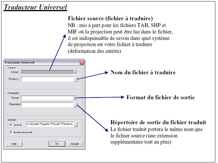
Il existe cependant un autre outil, le Traducteur Universel, qui permet d’aller plus loin dans les échanges, car il traduit directement les fichiers issus/vers d’autres logiciels (DXF, SHP, E00…).
Le dessin ci-dessous présente le Traducteur Universel disponible à partir du menu Outils.
Lors de tout import ou export de fichiers, il est important de connaître le système de projection du fichier d’origine afin d’éviter toute déformation lors de la transformation !
Acquérir des données géographiques à partir de tables attributaires :
Certaines données ne présentent pas d’objets géographiques mais ceux ci peuvent être construits si on connaît leur localisation en X et en Y. C’est notamment le cas de points acquis sur le terrain à l’aide de systèmes de positionnement par satellites type GPS. Dans la plupart des cas les GPS permettent de récupérer des fichiers de points au format ASCII (format texte).
Pour ouvrir le fichier, reportez vous à la fiche correspondante.
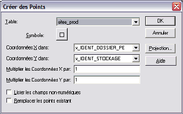
 Une fois le fichier ouvert, observez sa structure. La présence de coordonnées X et Y va nous permettre de créer pour chaque ligne du tableau un point avec les coordonnées correspondantes.
Pour cela passer par le menu table >créer points, et compléter la fenêtre ci-contre.
N’oubliez pas de renseigner le système de projection !


