Nous utilisons des cookies pour vous garantir la meilleure expérience sur notre site. Si vous continuez à utiliser ce dernier, nous considèrerons que vous acceptez l'utilisation des cookies. J'ai compris ! ou En savoir plus !.
banniere

Le portail francophone de la géomatique


Toujours pas inscrit ? Mot de passe oublié ?

Ceci est une ancienne révision du document !


Strict Standards: Declaration of syntax_plugin_tag_topic::handle() should be compatible with DokuWiki_Syntax_Plugin::handle($match, $state, $pos, Doku_Handler $handler) in /var/www/html/web/wiki/lib/plugins/tag/syntax/topic.php on line 123

Strict Standards: Declaration of syntax_plugin_tag_topic::render() should be compatible with DokuWiki_Syntax_Plugin::render($format, Doku_Renderer $renderer, $data) in /var/www/html/web/wiki/lib/plugins/tag/syntax/topic.php on line 123

Strict Standards: Declaration of syntax_plugin_tag_searchtags::handle() should be compatible with DokuWiki_Syntax_Plugin::handle($match, $state, $pos, Doku_Handler $handler) in /var/www/html/web/wiki/lib/plugins/tag/syntax/searchtags.php on line 280

Strict Standards: Declaration of syntax_plugin_tag_searchtags::render() should be compatible with DokuWiki_Syntax_Plugin::render($format, Doku_Renderer $renderer, $data) in /var/www/html/web/wiki/lib/plugins/tag/syntax/searchtags.php on line 280

Strict Standards: Declaration of syntax_plugin_tag_tag::handle() should be compatible with DokuWiki_Syntax_Plugin::handle($match, $state, $pos, Doku_Handler $handler) in /var/www/html/web/wiki/lib/plugins/tag/syntax/tag.php on line 118

Strict Standards: Declaration of syntax_plugin_tag_tag::render() should be compatible with DokuWiki_Syntax_Plugin::render($format, Doku_Renderer $renderer, $data) in /var/www/html/web/wiki/lib/plugins/tag/syntax/tag.php on line 118

Strict Standards: Declaration of syntax_plugin_tag_count::handle() should be compatible with DokuWiki_Syntax_Plugin::handle($match, $state, $pos, Doku_Handler $handler) in /var/www/html/web/wiki/lib/plugins/tag/syntax/count.php on line 130

Strict Standards: Declaration of syntax_plugin_tag_count::render() should be compatible with DokuWiki_Syntax_Plugin::render($format, Doku_Renderer $renderer, $data) in /var/www/html/web/wiki/lib/plugins/tag/syntax/count.php on line 130

Strict Standards: Declaration of syntax_plugin_tag_tagpage::handle() should be compatible with DokuWiki_Syntax_Plugin::handle($match, $state, $pos, Doku_Handler $handler) in /var/www/html/web/wiki/lib/plugins/tag/syntax/tagpage.php on line 96

Strict Standards: Declaration of syntax_plugin_tag_tagpage::render() should be compatible with DokuWiki_Syntax_Plugin::render($format, Doku_Renderer $renderer, $data) in /var/www/html/web/wiki/lib/plugins/tag/syntax/tagpage.php on line 96

Strict Standards: Declaration of syntax_plugin_clearfloat::handle() should be compatible with DokuWiki_Syntax_Plugin::handle($match, $state, $pos, Doku_Handler $handler) in /var/www/html/web/wiki/lib/plugins/clearfloat/syntax.php on line 74

Strict Standards: Declaration of syntax_plugin_clearfloat::render() should be compatible with DokuWiki_Syntax_Plugin::render($format, Doku_Renderer $renderer, $data) in /var/www/html/web/wiki/lib/plugins/clearfloat/syntax.php on line 74

Strict Standards: Declaration of syntax_plugin_pageindex::handle() should be compatible with DokuWiki_Syntax_Plugin::handle($match, $state, $pos, Doku_Handler $handler) in /var/www/html/web/wiki/lib/plugins/pageindex/syntax.php on line 187

Strict Standards: Declaration of syntax_plugin_pageindex::render() should be compatible with DokuWiki_Syntax_Plugin::render($format, Doku_Renderer $renderer, $data) in /var/www/html/web/wiki/lib/plugins/pageindex/syntax.php on line 187

Strict Standards: Declaration of syntax_plugin_googlemaps_googlemap::handle() should be compatible with DokuWiki_Syntax_Plugin::handle($match, $state, $pos, Doku_Handler $handler) in /var/www/html/web/wiki/lib/plugins/googlemaps/syntax/googlemap.php on line 169

Strict Standards: Declaration of syntax_plugin_googlemaps_googlemap::render() should be compatible with DokuWiki_Syntax_Plugin::render($format, Doku_Renderer $renderer, $data) in /var/www/html/web/wiki/lib/plugins/googlemaps/syntax/googlemap.php on line 169

Strict Standards: Declaration of syntax_plugin_nextpage::handle() should be compatible with DokuWiki_Syntax_Plugin::handle($match, $state, $pos, Doku_Handler $handler) in /var/www/html/web/wiki/lib/plugins/nextpage/syntax.php on line 69

Strict Standards: Declaration of syntax_plugin_nextpage::render() should be compatible with DokuWiki_Syntax_Plugin::render($format, Doku_Renderer $renderer, $data) in /var/www/html/web/wiki/lib/plugins/nextpage/syntax.php on line 69

Strict Standards: Declaration of syntax_plugin_include::handle() should be compatible with DokuWiki_Syntax_Plugin::handle($match, $state, $pos, Doku_Handler $handler) in /var/www/html/web/wiki/lib/plugins/include/syntax.php on line 137

Strict Standards: Declaration of syntax_plugin_include::render() should be compatible with DokuWiki_Syntax_Plugin::render($format, Doku_Renderer $renderer, $data) in /var/www/html/web/wiki/lib/plugins/include/syntax.php on line 137
Plugin installed incorrectly. Rename plugin directory 'backlinks.old' to 'backlinks'.

Modification d’objets sémantiques

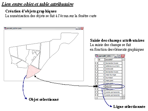
La modification des données attributaires se fait en concordance avec les objets graphiques correspondants.
Lors d’une modification (bien souvent une création) des données attributaires, il faut sélectionner l’entité sur la carte pour savoir à quelle ligne de la table correspond cette entité.

La sélection de l’objet sur la carte se matérialise par des hachures rouges (). Dans la table correspondante, la sélection se remarque par un carré noir devant la ligne coïncidant avec l’entité sélectionnée. La sélection de l’objet entraine la sélection de la ligne dans la table, et inversement.

Pour modifier les données de la table attributaire, il suffit d’ouvrir la table concernée (touche F2 ou menu Fenêtre >Données) et de modifier manuellement les cellules en se plaçant dessus. Il faut aussi enregistrer les modifications apportées à la table en fin de travail.

Le « re-calcul » des données d’une colonne (champ) entière se fait à partir du menu Table >Mettre à jour colonne. Une boîte de dialogue apparaît ; vous pouvez ainsi calculer vos valeurs suivant une expression (exemple : surface du polygone en hectares Area(obj, “sq km”)*100 ou Area(obj, “hectare”), coordonnées X et Y CentroidX(obj) et CentroidY(obj), ratio de deux colonnes…).
N’hésitez pas à consulter l’aide (bouton Aide dans la fenêtre Expression) qui donne beaucoup d’exemples sur la syntaxe.

Il est indispensable d’enregistrer les modifications opérées sur la table dans le menu Fichier > Enregistrer table (case grisée lorsque aucune table n’a été modifiée).

 
main/logiciels/mapinfo/documents/modification_d_objets_semantiques.1244726960.txt.gz · Dernière modification: 2009/06/11 15:29 par geomatikfab
Recent changes RSS feed Creative Commons License Valid XHTML 1.0 Valid CSS Driven by DokuWiki