Nous utilisons des cookies pour vous garantir la meilleure expérience sur notre site. Si vous continuez à utiliser ce dernier, nous considèrerons que vous acceptez l'utilisation des cookies. J'ai compris ! ou En savoir plus !.
banniere

Le portail francophone de la géomatique


Toujours pas inscrit ? Mot de passe oublié ?

Ceci est une ancienne révision du document !


Strict Standards: Declaration of syntax_plugin_tag_topic::handle() should be compatible with DokuWiki_Syntax_Plugin::handle($match, $state, $pos, Doku_Handler $handler) in /var/www/html/web/wiki/lib/plugins/tag/syntax/topic.php on line 123

Strict Standards: Declaration of syntax_plugin_tag_topic::render() should be compatible with DokuWiki_Syntax_Plugin::render($format, Doku_Renderer $renderer, $data) in /var/www/html/web/wiki/lib/plugins/tag/syntax/topic.php on line 123

Strict Standards: Declaration of syntax_plugin_tag_searchtags::handle() should be compatible with DokuWiki_Syntax_Plugin::handle($match, $state, $pos, Doku_Handler $handler) in /var/www/html/web/wiki/lib/plugins/tag/syntax/searchtags.php on line 280

Strict Standards: Declaration of syntax_plugin_tag_searchtags::render() should be compatible with DokuWiki_Syntax_Plugin::render($format, Doku_Renderer $renderer, $data) in /var/www/html/web/wiki/lib/plugins/tag/syntax/searchtags.php on line 280

Strict Standards: Declaration of syntax_plugin_tag_tag::handle() should be compatible with DokuWiki_Syntax_Plugin::handle($match, $state, $pos, Doku_Handler $handler) in /var/www/html/web/wiki/lib/plugins/tag/syntax/tag.php on line 118

Strict Standards: Declaration of syntax_plugin_tag_tag::render() should be compatible with DokuWiki_Syntax_Plugin::render($format, Doku_Renderer $renderer, $data) in /var/www/html/web/wiki/lib/plugins/tag/syntax/tag.php on line 118

Strict Standards: Declaration of syntax_plugin_tag_count::handle() should be compatible with DokuWiki_Syntax_Plugin::handle($match, $state, $pos, Doku_Handler $handler) in /var/www/html/web/wiki/lib/plugins/tag/syntax/count.php on line 130

Strict Standards: Declaration of syntax_plugin_tag_count::render() should be compatible with DokuWiki_Syntax_Plugin::render($format, Doku_Renderer $renderer, $data) in /var/www/html/web/wiki/lib/plugins/tag/syntax/count.php on line 130

Strict Standards: Declaration of syntax_plugin_tag_tagpage::handle() should be compatible with DokuWiki_Syntax_Plugin::handle($match, $state, $pos, Doku_Handler $handler) in /var/www/html/web/wiki/lib/plugins/tag/syntax/tagpage.php on line 96

Strict Standards: Declaration of syntax_plugin_tag_tagpage::render() should be compatible with DokuWiki_Syntax_Plugin::render($format, Doku_Renderer $renderer, $data) in /var/www/html/web/wiki/lib/plugins/tag/syntax/tagpage.php on line 96

Strict Standards: Declaration of syntax_plugin_clearfloat::handle() should be compatible with DokuWiki_Syntax_Plugin::handle($match, $state, $pos, Doku_Handler $handler) in /var/www/html/web/wiki/lib/plugins/clearfloat/syntax.php on line 74

Strict Standards: Declaration of syntax_plugin_clearfloat::render() should be compatible with DokuWiki_Syntax_Plugin::render($format, Doku_Renderer $renderer, $data) in /var/www/html/web/wiki/lib/plugins/clearfloat/syntax.php on line 74

Strict Standards: Declaration of syntax_plugin_pageindex::handle() should be compatible with DokuWiki_Syntax_Plugin::handle($match, $state, $pos, Doku_Handler $handler) in /var/www/html/web/wiki/lib/plugins/pageindex/syntax.php on line 187

Strict Standards: Declaration of syntax_plugin_pageindex::render() should be compatible with DokuWiki_Syntax_Plugin::render($format, Doku_Renderer $renderer, $data) in /var/www/html/web/wiki/lib/plugins/pageindex/syntax.php on line 187

Strict Standards: Declaration of syntax_plugin_googlemaps_googlemap::handle() should be compatible with DokuWiki_Syntax_Plugin::handle($match, $state, $pos, Doku_Handler $handler) in /var/www/html/web/wiki/lib/plugins/googlemaps/syntax/googlemap.php on line 169

Strict Standards: Declaration of syntax_plugin_googlemaps_googlemap::render() should be compatible with DokuWiki_Syntax_Plugin::render($format, Doku_Renderer $renderer, $data) in /var/www/html/web/wiki/lib/plugins/googlemaps/syntax/googlemap.php on line 169

Strict Standards: Declaration of syntax_plugin_nextpage::handle() should be compatible with DokuWiki_Syntax_Plugin::handle($match, $state, $pos, Doku_Handler $handler) in /var/www/html/web/wiki/lib/plugins/nextpage/syntax.php on line 69

Strict Standards: Declaration of syntax_plugin_nextpage::render() should be compatible with DokuWiki_Syntax_Plugin::render($format, Doku_Renderer $renderer, $data) in /var/www/html/web/wiki/lib/plugins/nextpage/syntax.php on line 69

Strict Standards: Declaration of syntax_plugin_include::handle() should be compatible with DokuWiki_Syntax_Plugin::handle($match, $state, $pos, Doku_Handler $handler) in /var/www/html/web/wiki/lib/plugins/include/syntax.php on line 137

Strict Standards: Declaration of syntax_plugin_include::render() should be compatible with DokuWiki_Syntax_Plugin::render($format, Doku_Renderer $renderer, $data) in /var/www/html/web/wiki/lib/plugins/include/syntax.php on line 137
Plugin installed incorrectly. Rename plugin directory 'backlinks.old' to 'backlinks'.

Sommaire GeoLibre || QGIS Sommaire

Généralité

Lorsque vous lancez QGIS, après l'écran de démarrage une fenêtre principale s'ouvre. Celle-ci ressemble à la copie d'écran, hormis le fait qu'il n'y a pas de couches chargée. Vous avez une barre d'outils, plus ou moins complète (la capture d'écran montre des icônes de plugins qui doivent être installé). Vous avez à gauche la partie qui affiche les informations sur les couches chargées (au minimum le nom de la couche, au maximum l'analyse thématique effectuée sur la couche vectorielle). Au milieu la carte …
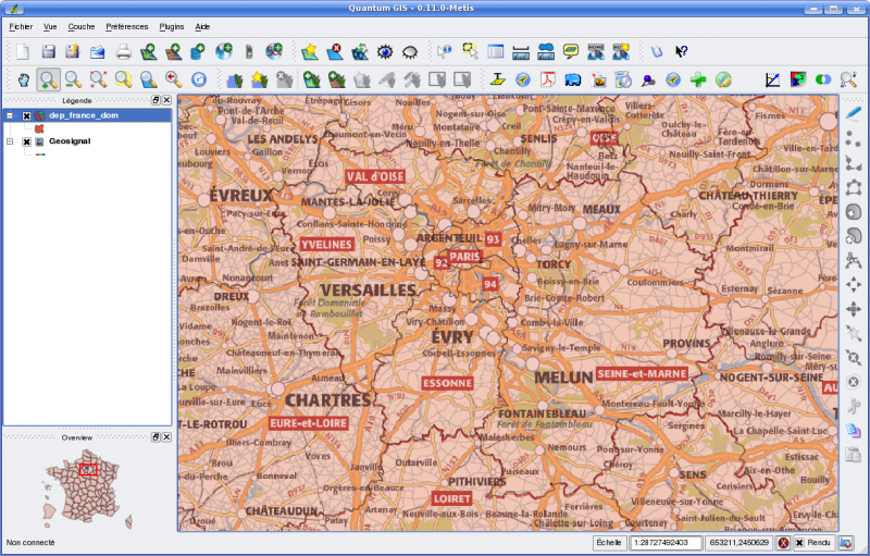
Un exemple de carte dans QGIS : une couche WMS (géosignal) et une couche vectorielle (GeoFla, IGN)

Enfin en bas à gauche, vous avez la possibilité d'ajouter des couches chargées dans une vue généralisée. Celle-ci vous permet de vous situer lorsque vous zoomer. D'autres sections sont intéressantes. Par exemple en bas à droite, vous avez des informations sur l'échelle, la possibilité de désactiver le rendu de la carte si vous avez plusieurs actions à mener sans que la carte soit rechargée et une icône pour accéder à la gestion de la projection du projet.

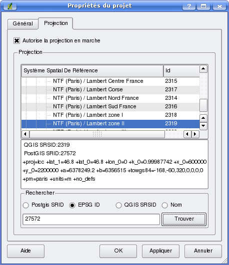
Lors de l'ouverture d'un premier projet, définissez toujours une projection en cliquant sur l'icône en bas à droite ou par le menu PréférencePropriété du projet, onglet Projection.

Si vous chargée des couches avec des projections différentes de celle du projet, cochez la case Autoriser la projection en marche. Dénomination pas très clair qui signifie que QGIS va reprojeter à la volée (plutôt qu'en marche) les couches de projections différentes.

Fenêtre de définition de la projection du projet


Yves Jacolin 2008/08/28 13:46

 
main/logiciels/qgis/generalite.1219923994.txt.gz · Dernière modification: 2009/04/15 20:57 (modification externe)
Recent changes RSS feed Creative Commons License Valid XHTML 1.0 Valid CSS Driven by DokuWiki