- Vous êtes ici: Accéder au Wiki GeoRezo » Accueil : Wiki GeoRezo » Les logiciels en géomatique » Spatial Data Integrator (SDI)
Ceci est une ancienne révision du document !
Strict Standards: Declaration of syntax_plugin_googlemaps_googlemap::handle() should be compatible with DokuWiki_Syntax_Plugin::handle($match, $state, $pos, Doku_Handler $handler) in /var/www/html/web/wiki/lib/plugins/googlemaps/syntax/googlemap.php on line 169
Strict Standards: Declaration of syntax_plugin_googlemaps_googlemap::render() should be compatible with DokuWiki_Syntax_Plugin::render($format, Doku_Renderer $renderer, $data) in /var/www/html/web/wiki/lib/plugins/googlemaps/syntax/googlemap.php on line 169
Strict Standards: Declaration of syntax_plugin_nextpage::handle() should be compatible with DokuWiki_Syntax_Plugin::handle($match, $state, $pos, Doku_Handler $handler) in /var/www/html/web/wiki/lib/plugins/nextpage/syntax.php on line 69
Strict Standards: Declaration of syntax_plugin_nextpage::render() should be compatible with DokuWiki_Syntax_Plugin::render($format, Doku_Renderer $renderer, $data) in /var/www/html/web/wiki/lib/plugins/nextpage/syntax.php on line 69
Strict Standards: Declaration of syntax_plugin_pageindex::handle() should be compatible with DokuWiki_Syntax_Plugin::handle($match, $state, $pos, Doku_Handler $handler) in /var/www/html/web/wiki/lib/plugins/pageindex/syntax.php on line 177
Strict Standards: Declaration of syntax_plugin_pageindex::render() should be compatible with DokuWiki_Syntax_Plugin::render($format, Doku_Renderer $renderer, $data) in /var/www/html/web/wiki/lib/plugins/pageindex/syntax.php on line 177
Table des matières
SpatialDataIntegrator
Introduction
SpatialDataIntegrator est un ETL (pour Extract, Transform et Loading) spatial open source au même titre que FME, son équivalent propriétaire (au niveau fonctionnel pas au niveau fonctionnalité). Il est basé sur Talend Open Studio, un ETL non spatial de la société française Talend. L'éditeur de la version spatiale est la société d'édition de logiciels open source Camptocamp.
- site officiel : http://spatialdataintegrator.com/
- bugtracker : talendforge
Dépendances :
- Java ;
- JAI : jai.dev.java.net ;
Présentation
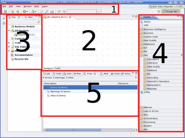
Cette section a pour but de présenter rapidement l'outil et de donner quelques exemples. SpatialDataIntegrator (ou SDI en plus court) étant basé sur Talend Open Studio, il est développé en utilisant Eclipse en JAVA. Il se présente sous forme d'une archive à décompresser d'une taille assez conséquence (entre 200 et 300 Mo). Après décompression, vous devez double-cliquer sur le fichier exécutable pour lancer l'application.
- barre de menu et d'outils ;
- zone de travail où l'on place et interconnecte les components ;
- gestionnaire de projets : jobs, méta-données (configuration des connections aux bases de données, schéma de fichier, etc.), paramètres contextuels, etc.
- palette de composants, classés par catégorie ;
- zone de gestion des jobs : lancement, configuration des composants, etc.
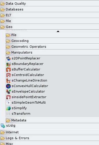
SDI permet de créer des scripts plus ou moins complexe d'extraction, de transformation et de chargement de données spatiales. Les formats de données gérés sont les formats Shape, mif/mid, GeoRSS et PostGIS en lecture/écriture, et WFS, EDIGeo et GPX en lecture seule. La liste des composants disponibles sont listés dans cette page. Voir la capture d'écran pour un visuel des composants disponibles :

SDI gère donc les données spatiales et les géoreférencements. La liste des formats gérés est encore succincte mais les formats principaux y sont intégrés.
Documentations
- créer un job ;
- utiliser les méta-données ;
- utiliser les paramètres contextuels ;
- job plus complexe ;
- gestion des jobs et mise en production ;
- gestion des erreurs, des informations, etc.
- débuguer ;


