
Vous pouvez lire le billet sur le blog La Minute pour plus d'informations sur les RSS !
Canaux
7062 éléments (529 non lus) dans 56 canaux
 Dans la presse
(390 non lus)
Dans la presse
(390 non lus)
-
 Cybergeo
(323 non lus)
Cybergeo
(323 non lus) -
Revue Internationale de Géomatique (RIG)
-
SIGMAG & SIGTV.FR - Un autre regard sur la géomatique
(6 non lus)
-
Mappemonde
(60 non lus)
-
Dans les algorithmes
(1 non lus)
Du côté des éditeurs
(19 non lus)
-
Imagerie Géospatiale
-
Toute l’actualité des Geoservices de l'IGN
(15 non lus)
-
arcOrama, un blog sur les SIG, ceux d ESRI en particulier (4 non lus)
-
arcOpole - Actualités du Programme
-
Géoclip, le générateur d'observatoires cartographiques
-
Blog GEOCONCEPT FR
Toile géomatique francophone
(91 non lus)
-
Géoblogs (GeoRezo.net) (5 non lus)
-
Conseil national de l'information géolocalisée
(11 non lus)
-
Évènements – Afigéo
-
 Geotribu
-
Les cafés géographiques
(5 non lus)
-
UrbaLine (le blog d'Aline sur l'urba, la géomatique, et l'habitat)
-
Icem7
-
Séries temporelles (CESBIO)
(2 non lus)
-
Datafoncier, données pour les territoires (Cerema)
-
Cartes et figures du monde
-
SIGEA: actualités des SIG pour l'enseignement agricole
-
Data and GIS tips
-
Neogeo Technologies
-
ReLucBlog
-
L'Atelier de Cartographie
-
My Geomatic
-
archeomatic (le blog d'un archéologue à l’INRAP)
-
Cartographies numériques
-
Veille cartographie
-
Makina Corpus (1 non lus)
-
Oslandia
(2 non lus)
-
Camptocamp
(51 non lus)
-
Carnet (neo)cartographique
-
GEOMATIQUE
-
Le blog de Geomatys
(2 non lus)
-
Geomatick
-
CartONG (actualités)
-
Afigéo
(12 non lus)
Géomatique anglophone
(19 non lus)

opensource
-
 2:00
2:00 PostGIS Development: PostGIS Patch Releases
sur Planet OSGeo -
12:00
Mappery: Candy Jar
sur Planet OSGeo
Koen Rutten shared this candy jar.
“#mapsInTheWild My new candy jar! Made by Royal Goedewaagen to the design of Sander Alblas. In my case: a second-hand one.”
-
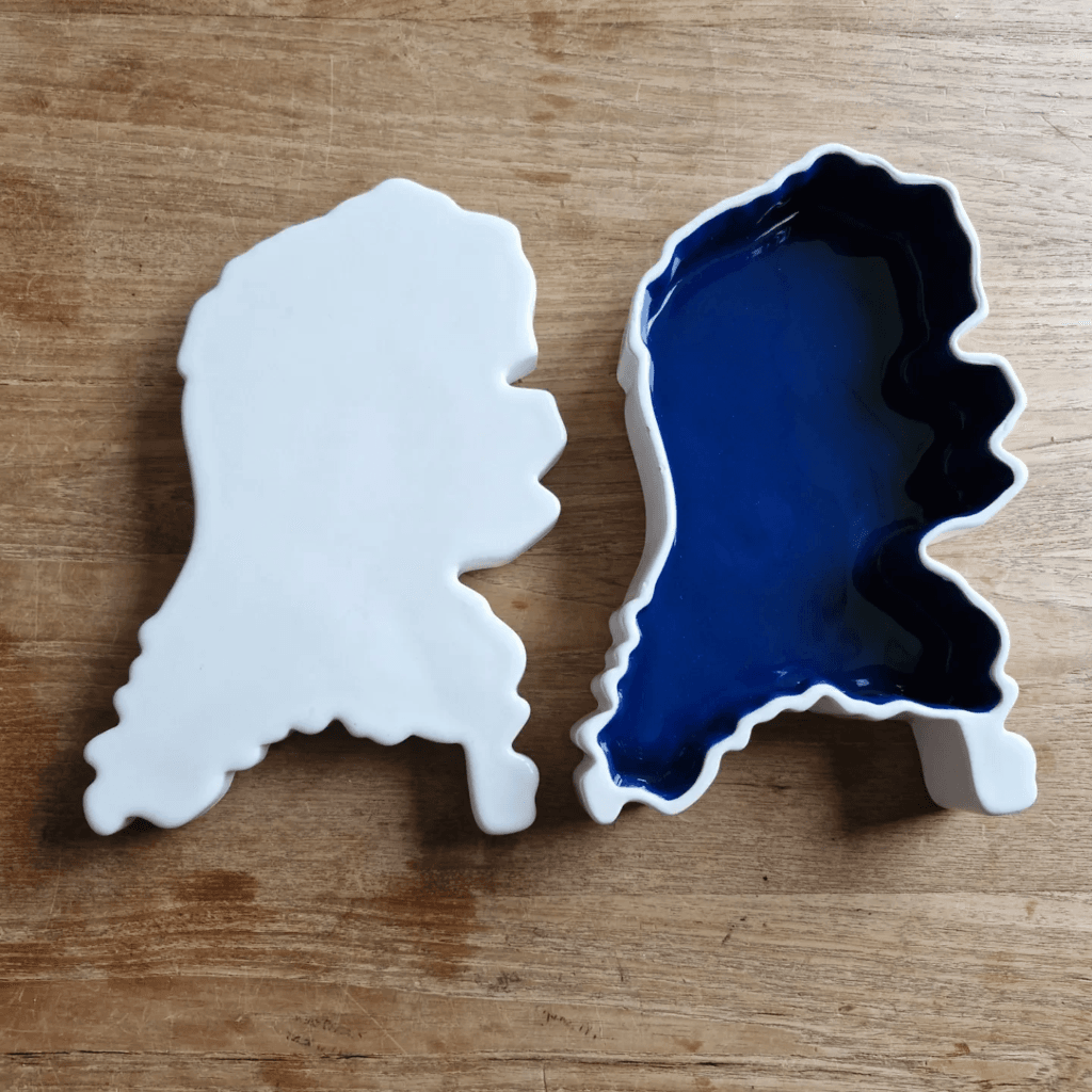
12:00
Mappery: From the Heart
sur Planet OSGeoPièce jointe: [télécharger]
Another map shared by Le Cartographe during a trip to Portugal.
-
12:00
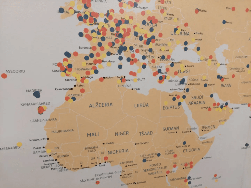
Mappery: How far have you flown from Tartu
sur Planet OSGeo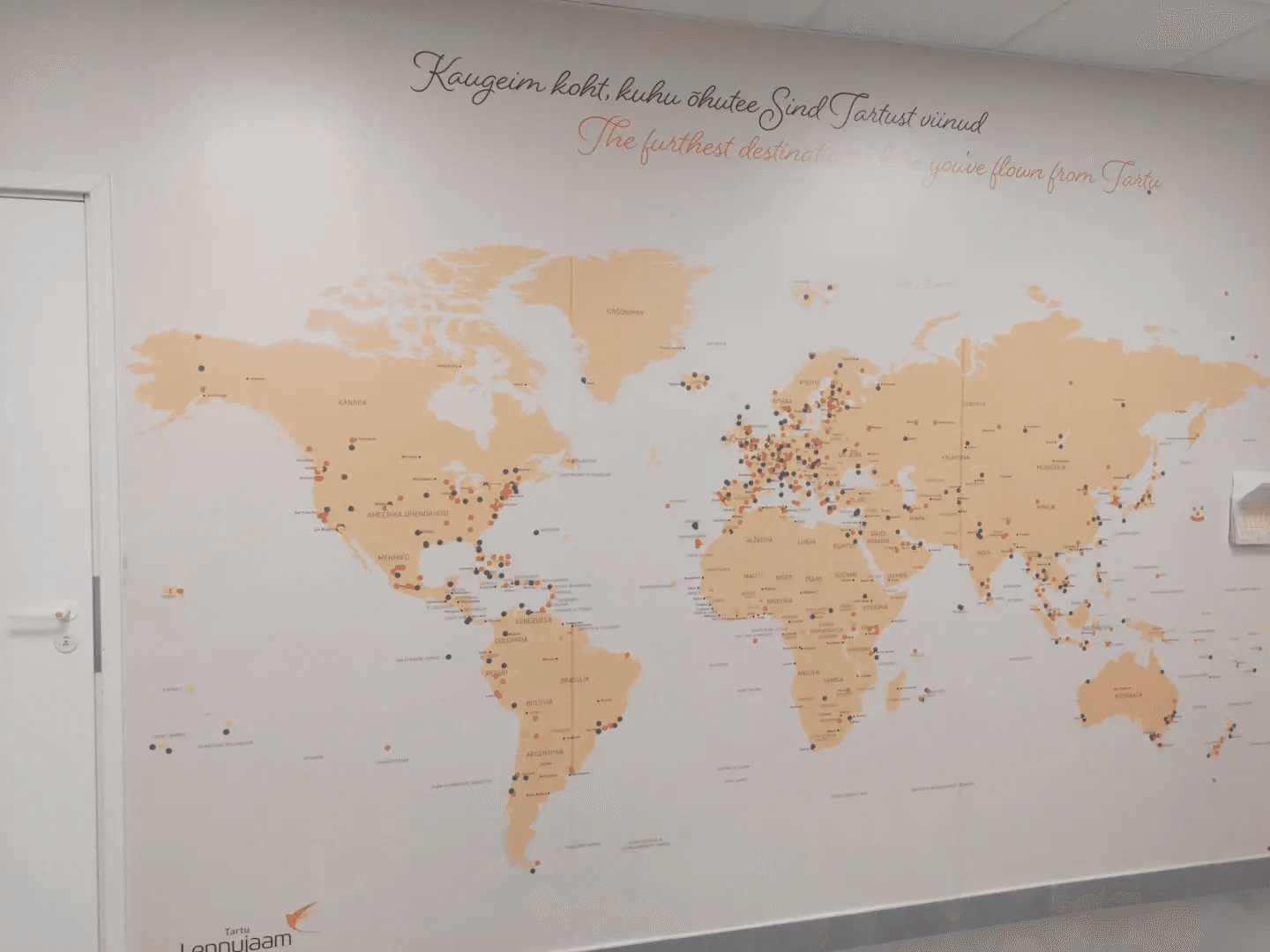
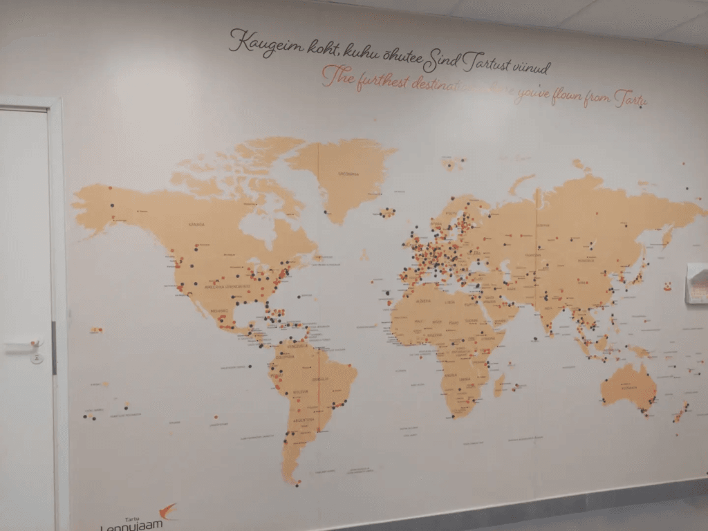
Ivan Sanchez Ortega spottted this big wall map in Tartu airport. People have placed coloured dots representing the furthest distance they have flown from Tartu. Not sure if the colours have added significance.
-
1:22
TorchGeo: v0.6.2
sur Planet OSGeoTorchGeo 0.6.2 Release NotesThis is a bugfix release. There are no new features or API changes with respect to the 0.6.1 release.
This release doubles the number of TorchGeo tutorials, making it easier than ever to learn TorchGeo! All tutorials have been reorganized as follows:
- Getting Started: background material on PyTorch, geospatial data, and TorchGeo
- Basic Usage: basic concepts and components of TorchGeo and how to use them
- Case Studies: end-to-end workflows for common remote sensing use cases
- Customization: customizing TorchGeo to meet your needs, and contributing back those changes
If you have a use case that is not yet documented, please consider contributing a new Case Study tutorial!
Dependencies Datasets- Chesapeake 7/13: remove references to removed classes (#2388)
- Chesapeake CVPR: fix download link (#2445)
- EuroSAT: fix order of Sentinel-2 bands (#2480)
- EuroSAT: redistribute split files on Hugging Face (#2432)
- Forest Damage: fix _verify docstring (#2401)
- Million-AID: fix _verify docstring (#2401)
- UC Merced: redistribute split files on Hugging Face (#2433)
- Utilities: remove defaultdict from collation functions (#2398)
- Add
bandsmetadata to all pre-trained weights (#2376)
- SSL4EO: Sentinel-2 name changed on GEE (#2421)
- CI: more human-readable cache names (#2426)
- Models: test that
bandsmatch expected dimensions (#2383)
- Docs: update alternatives (#2437)
- Docs: reorganize tutorial hierarchy (#2439)
- Add Introduction to PyTorch tutorial (#2440, #2467)
- Add Introduction to Geospatial Data tutorial (#2446, #2467)
- Add Introduction to TorchGeo tutorial (#2457)
- Add TorchGeo CLI tutorial (#2479)
- Add Earth Surface Water tutorial (#960)
- Add contribution tutorial for Non-Geo Datasets (#2451, #2469)
- Add contribution tutorial for Data Modules (#2452)
- Add consistent author and copyright info to all tutorials (#2478)
- Update tutorial for transforms and pretrained weights (#2454)
- README: correct syntax highlighting for console code (#2482)
- README: root -> paths for GeoDatasets (#2438)
This release is thanks to the following contributors:
@adamjstewart
@calebrob6
@cordmaur
@giswqs
@hfangcat
@InderParmar
@lhackel-tub
@nilsleh
@yichiac -
12:09
GeoTools Team: GeoTools 31.5
sur Planet OSGeoGeoTools 31.5 released The GeoTools team is pleased to announce the release of the latest maintenance version of GeoTools 31.5: geotools-31.5-bin.zip geotools-31.5-doc.zip geotools-31.5-userguide.zip geotools-31.5-project.zip This release is also available from the OSGeo Maven Repository and is made in conjunction with GeoServer -
12:00
Mappery: Nobody Is Illegal
sur Planet OSGeo


-
8:25
[Equipe Oslandia] Sophie Aubier, développeuse SIG
sur Oslandia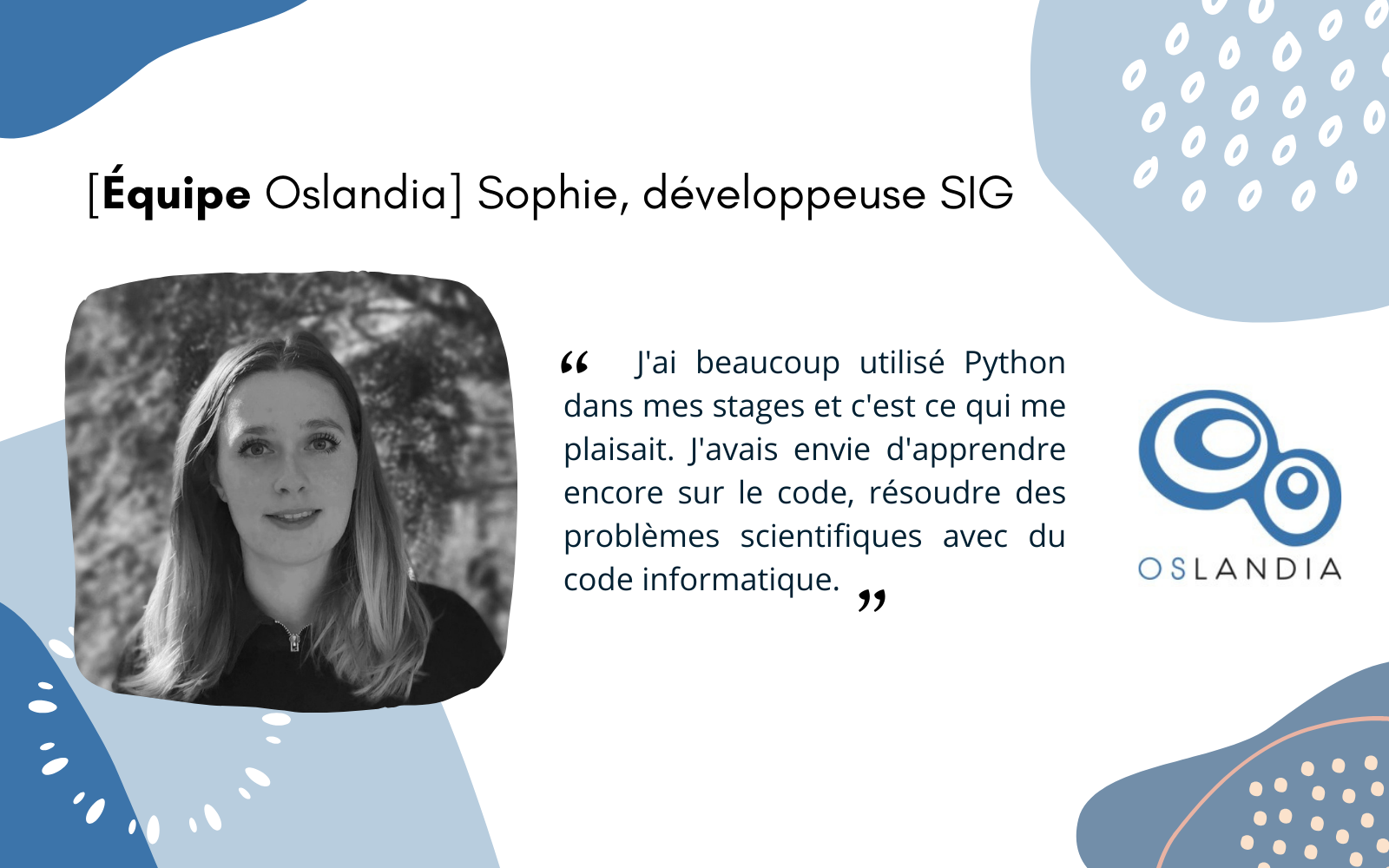
Après le BAC, le rêve de Sophie, c’est de tailler des pierres précieuses. Elle effectue un stage chez un artisan parisien où elle se rend vite compte que c’est un travail précaire qui est soumis à des règles qui ne lui conviennent pas.
Elle décide d’en apprendre plus sur la formation des roches et s’oriente vers une Licence de Géosciences à Paris Sorbonne puis un master de Physique de l’Océan, de l’Atmosphère et du Climat qu’elle complète avec un Master d’Hydrogéologie à Paris Saclay pour « plus de pratique et moins de théorie ».« Je me suis intéressée à la géologie pour finalement plus me passionner pour le calcaire que pour les pierres précieuses ! »
Pendant ses études, Sophie réalise plusieurs stages pendant lesquels elle mobilise les grands modèles utilisés par le GIEC pour les prédictions afin de réaliser des modélisations du climat.
« J’ai beaucoup utilisé Python dans mes stages et c’est ce qui me plaisait. J’avais envie d’apprendre encore sur le code, résoudre des problèmes scientifiques avec du code informatique. »
Sophie postule à une offre d’emploi chez Oslandia à un poste de développeur SIG junior. Elle est embauchée en janvier 2022 pour notamment développer des plugins QGIS en Python.
Projets emblématiques- Développement du plugin Cityforge : intégration de bâtiments 3D dans QGIS. Un plugin réalisé dans le cadre de la R&D Oslandia.
- Développement du plugin ELAN pour INRAE : un plugin d’outils de gestion des eaux urbaines.
« C’est un outil d’aide à la décision pour le traitement des eaux usées, le déversement des eaux de pluie et des eaux usées «
Python
PhilosophieApprendre !
Oslandia en 1 motAutonomie
-
17:43
KAN T&IT Blog: GeoNode Cloud: Presentación oficial
sur Planet OSGeo ¡Ha llegado el momento! Presentamos GeoNode Cloud, la plataforma en la nube que transforma la gestión de datos geoespaciales.
 Sin necesidad de infraestructura interna. Escalable y confiable gracias a Kubernetes. Una solución para todos: comunidad open source, sector privado y gobierno.
 GeoNode Cloud te ayuda a lograr más con menos esfuerzo
 Empezá a explorar: GitHub – Kan-T-IT/geonode-cloud: GeoNode Cloud es una implementación avanzada de la plataforma GeoNode para la nube, integrando Geoserver Cloud para su implementación en Kubernetes.
¿Querés saber más? ¡escribinos! info@kan.com.ar o contestá este posteo#GeoNodeCloud #OpenSource #GeospatialData #CloudComputing #Nube #DatosGeoespaciales #GIS #Cloud #AWS #K8s #Kubernete #digitaltwin #smartcity
Versión en inglés: The time has come! Introducing GeoNode Cloud, the cloud platform that revolutionizes geospatial data management. No internal infrastructure needed. Scalable and reliable, powered by Kubernetes. A solution for everyone: the open-source community, private sector, and government. GeoNode Cloud helps you achieve more with less effort. Start exploring:GitHub – Kan-T-IT/geonode-cloud: GeoNode Cloud is an advanced implementation of the GeoNode platform for the cloud, integrating Geoserver Cloud for deployment on Kubernetes.Want to learn more? Write to us at info@kan.com.ar or reply to this post.
#GeoNodeCloud #OpenSource #GeospatialData #CloudComputing #Cloud #Geospatial #GIS #AWS #K8s #Kubernetes #DigitalTwin #SmartCity
-
12:00
Mappery: Global Fire Pit
sur Planet OSGeoPièce jointe: [télécharger]
Alfons shared this, he asked “Is this meant to be macabre, cynical or educational?”
-
8:18
Petite histoire du logo Oslandia
sur Oslandia
Fin 2009, Oslandia est sur le point d’être créée… et a besoin d’une identité visuelle. Vincent contacte son ancien collègue Sylvain pour travailler sur un logo.
Le cahier des charges est lancé !Le logo doit être identifiable immédiatement, le plus simple possible (“ça va ensemble” dixit Sylvain), déclinable au trait (N&B), niveau de gris, quadrichromie, 256 couleurs et couleurs pleines. Il faut aussi qu’il soit symbole de dynamisme, avec une symbolique rattachée au métier, et ne ressemblant à rien de connu !
La première série d’idées ne se fait pas attendre, voilà quelques logos proposés :
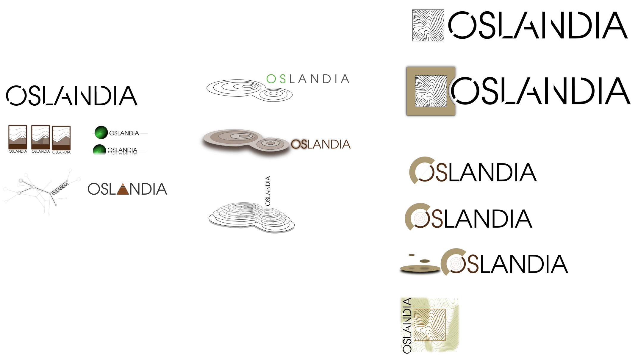
Les partages d’idées se font via des emails et sont centralisés sur un wiki. Les premiers échanges débutent ! Et une série de modifications qui donne lieu à une nouvelle itération.
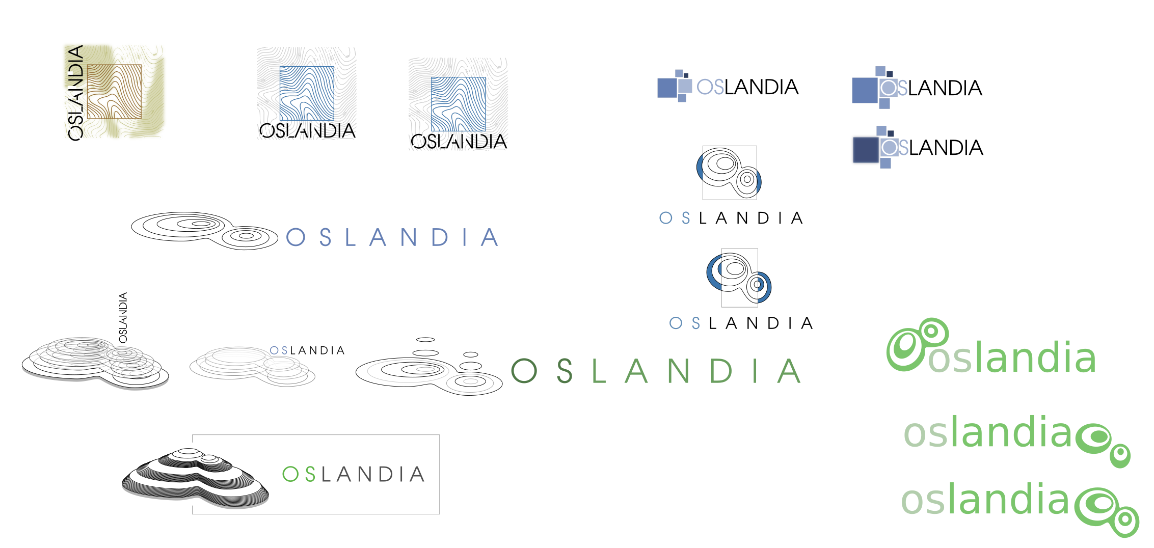
On avance !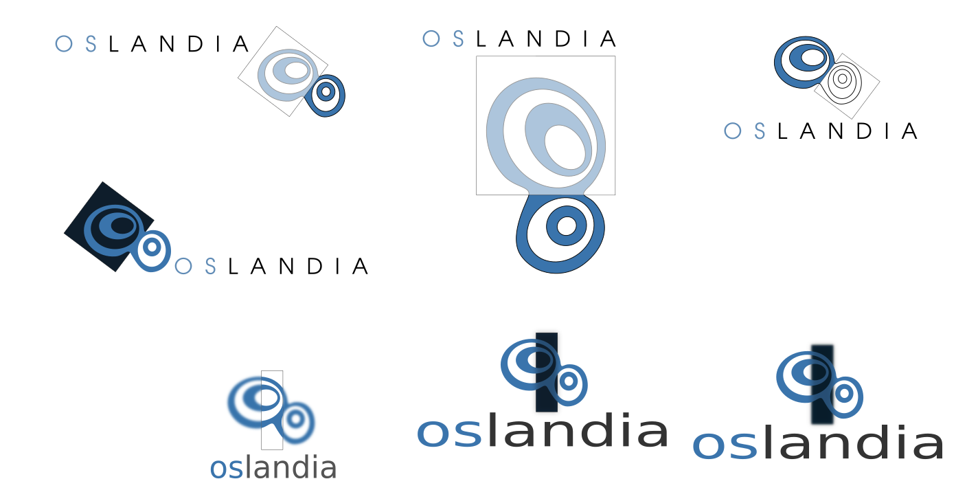
Pour s’approcher d’une version finale
Qui ne tarde pas à arriver !
Retour d’expérience de Sylvain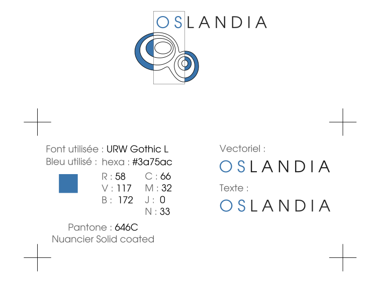
« J’ai exclusivement travaillé avec Inkscape, toujours en vectoriel et uniquement à la souris. Sur ce type d’exercice, je n’ai pas besoin de crayon pour élaborer des ébauches, je pars souvent d’une forme géométrique simple ou d’un texte. Je me suis basé sur mon intuition pour les premières séries et les itérations m’ont permis d’avancer pas à pas. «
Au final, le logo Oslandia représente une sorte d’intersection spatiale entre des courbes de niveau ( une île ? ) et un rectangle, qui fait le lien avec le nom de l’entreprise.
Certains y voient cependant plutôt des attracteurs étranges, ce qui in fine pourrait aussi nous caractériser !
Le logo s’est construit à l’image d’Oslandia : de manière collaborative, démocratique, par itération et tout cela dans un soucis d’excellence et de travail bien fait
Depuis, le logo a évolué pour aboutir à la version actuelle. Cette nouvelle version, largement inspirée de la précédente, est simplifiée et modernisée. Elle est toujours facile à intégrer sur des pages web, des affiches ou des documents, et elle corrige le bug de la version précédente : un affichage possible au format carré !

-
2:00
GeoServer Team: GeoServer 2.25.5 Release
sur Planet OSGeoGeoServer 2.25.5 release is now available with downloads (bin, war, windows), along with docs and extensions.
This is a maintenance release of GeoServer providing existing installations with minor updates and bug fixes. GeoServer 2.25.5 is made in conjunction with GeoTools 31.5, and GeoWebCache 1.25.3. The final release of the 2.25 series is planned for February 2025, please start making plans for an upgrade to 2.26.x or newer.
Thanks to Andrea Aime (GeoSolutions) for making this release.
Release notesImprovement:
- GEOS-11612 Add system property support for Proxy base URL -> use headers activation
- GEOS-11616 GSIP 229 - File system access isolation
- GEOS-11644 Introducing the rest/security/acl/catalog/reload rest endpoint
Bug:
- GEOS-11494 WFS GetFeature request with a propertyname parameter fails when layer attributes are customized (removed or reordered)
- GEOS-11606 geofence-server imports obsolete asm dep
- GEOS-11611 When Extracting the WFS Service Name from the HTTP Request A Slash Before the Question Marks Causes Issues
- GEOS-11643 WCS input read limits can be fooled by geotiff reader
Task:
- GEOS-11609 Bump XStream from 1.4.20 to 1.4.21
- GEOS-11610 Update Jetty from 9.4.55.v20240627 to 9.4.56.v20240826
- GEOS-11631 Update MySQL driver to 9.1.0
For the complete list see 2.25.5 release notes.
Community UpdatesCommunity module development:
- GEOS-11635 Add support for opaque auth tokens in OpenID connect
- GEOS-11637 DGGS min/max resolution settings stop working after restart
Community modules are shared as source code to encourage collaboration. If a topic being explored is of interest to you, please contact the module developer to offer assistance.
About GeoServer 2.25 SeriesAdditional information on GeoServer 2.25 series:
- GeoServer 2.25 User Manual
- GeoServer 2024 Roadmap Plannings
- Raster Attribute Table extension
- Individual contributor clarification
Release notes: ( 2.25.5 | 2.25.4 | 2.25.3 | 2.25.2 | 2.25.1 | 2.25.0 | 2.25-RC )
-
14:25
OSGeo Announcements: [OSGeo-Announce] pgRouting graduates OSGeo Incubation
sur Planet OSGeoOSGeo welcomes pgRouting to its growing ecosystem of projects.
OSGeo is pleased to announce that pgRouting has graduated from incubation and is now a full-fledged OSGeo project.
pgRouting is an open-source extension in the PostGIS / PostgreSQL geospatial database, providing geospatial routing functionality.
Graduating incubation includes fulfilling requirements for open community operation, a responsible project governance model, code provenance, and general good project operation. Graduation is the OSGeo seal of approval for a project and gives potential users and the community at large an added confidence in the viability and safety of the project.
The pgRouitng Steering Committee collectively recognizes this as a big progressive step for the project.
pgRouting has been an active contributor and participant to various open source initiatives inside and outside OSGeo such as FOSS4G, OSGeo Code Sprints, OGC Code Sprints, Joint OSGeo-OGC-ASF (Apache Software Foundation) Code Sprints, and Google Summer of Code.
The pgRouitng PSC says, “We are excited about the future of the project within the OSGeo’s project ecosystem. We have been working to have a community of developers for the project sustainability. It is our honor to be an OSGeo project”.
The pgRouting PSC would like to thank our mentor, Angelos Tzotsos, and the OSGeo Incubation Committee for their assistance during this Incubator process.
Congratulations to the pgRouting community!
About pgRouting
pgRouting extends the PostGIS / PostgreSQL geospatial database to provide geospatial routing functionality. It is written in C++, C and SQL.
It is an open source PostgreSQL extension which implements several graph algorithms.
pgRouting library contains the following features:
- All Pairs Shortest Path algorithms: Floyd-Warshall and Johnson’s Algorithm
- Shortest Path and bi-directional algorithms: Dijkstra, A*
- Graph components, analysis and contraction algorithms.
- Traveling Sales Person
- Graph components, analysis and contraction algorithms.
- Shortest Path with turn restrictions
pgRouting is able to process geospatial and non geospatial graphs.
It’s processing extension execute a number of existing graph algorithms based on reliable software and libraries. It is written in such a way that gives the ability to hook a new graph algorithm in a clean way including the connection code to the database.
The pgRouting functions are standardized in terms of parameter types and names, decreasing the learning curve of a user.
pgRouting is very flexible with graph data input, in an inner SQL query and output with standardized column names, so you can process almost any kind of graph data stored in the database.
About OSGeo
The Open Source Geospatial Foundation is not-for-profit organization to “empower everyone with open source geospatial‘. The software foundation directly supports projects serving as an outreach and advocacy organization providing financial, organizational and legal support for the open source geospatial community.
OSGeo works with Re:Earth, QFieldCloud, GeoCat, T-Kartor, and other sponsors, along with our partners to foster an open approach to software, standards, data, and education.
2 posts - 2 participants
-
12:00
Mappery: London cap
sur Planet OSGeo
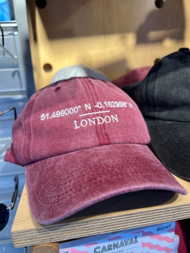

I found these caps in Camden, London. The coordinates point to the well-known Harrods of London.
-
11:59
Free and Open Source GIS Ramblings: Urban Mobility Insights with MovingPandas & CARTO in Snowflake
sur Planet OSGeoToday, I want to point out a blog post over at
written together with my fellow co-authors and EMERALDS project team member Argyrios Kyrgiazos.
For the technically inclined, the highlight are the presented UDFs in Snowflake to process and transform the trajectory data.

-
7:25
IASBIM, ou l’IA au service du BIM
sur OslandiaPièce jointe: [télécharger]
 Oslandia s’est récemment illustré au côté de Bimdata et le LIRIS dans le cadre du projet IASBIM, un projet R&D Booster financé par la région Auvergne Rhône-Alpes.
L’occasion nous était donnée d’explorer les relations entre les données BIM et le couple Py3dtiles/Giro3D, ainsi que de découvrir le potentiel de la segmentation sémantique appliquée aux nuages de points en 3D.
Contexte du projetLe projet IASBIM se proposait de mettre en avant les méthodes Scan-to-bim pour les acteurs du bâtiment et de la construction, en comblant le fossé entre les nuages de points 3D (captés notamment par Lidar) et les maquettes BIM (au format IFC). Dans cette optique, il s’agissait d’employer des méthodes d’intelligence artificielle et de reconstruction géométrique. Construire une méthodologie de scan-to-bim automatisée ou semi-automatisée peut ainsi permettre de participer à la transformation numérique du secteur de la construction.
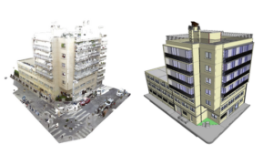
Scan-to-BIM: du nuage de points à la maquette BIM
Vers un nouveau procédé de Scan-to-BIMAinsi, à partir de scans 3D opérés sur le terrain fournis par Bimdata, Oslandia a ainsi eu l’opportunité de mettre en oeuvre un algorithme de segmentation sématnique 3D pour produire des nuages de points annotés. Cette information, une fois transmise au LIRIS, a alimenté les algorithmes de reconstruction géométrique développé par le laboratoire. Enfin, les géométries obtenues ont été récupérées par Bimdata, pour finalement être transformées en maquette BIM. Ces maquettes sont proposées en visualisation dans la plateforme Bimdata, qui a la particularité d’exploiter Giro3D.
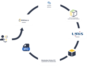
Chaîne de traitement de données construite à l’occasion de IASBIM
Réalisations OslandiaLes principaux chantiers pris en charge par Oslandia sont d’une part la visualisation web 3D, se décomposant en une partie backend représentée par Py3dtiles, pour le traitement amont des données 3D et une partie frontend représentée par Giro3D, et d’autre part, l’annotation sémantique de nuage de points, travail réalisé au moyen d’une implémentation de l’algorithme KPConv.
Visualisation web 3DPour la partie backend, nous avons pu établir l’importance de la hiérarchisation de la donnée BIM, avec le format 3DTiles ( [https:]] ), et détailler les éléments nécessaires à sa conversion vers ce format, notamment en respectant la hiérarchie intrinsèque des éléments constituant un jeu de données BIM ( [https:]] ).

Hiérarchie naturelle d’une donnée BIM
Du côté de la partie frontend, on peut noter qu’IASBIM a permis à la Giro3D de supporter l’affichage de maquettes BIM au format .ifc ( [https:]] ).
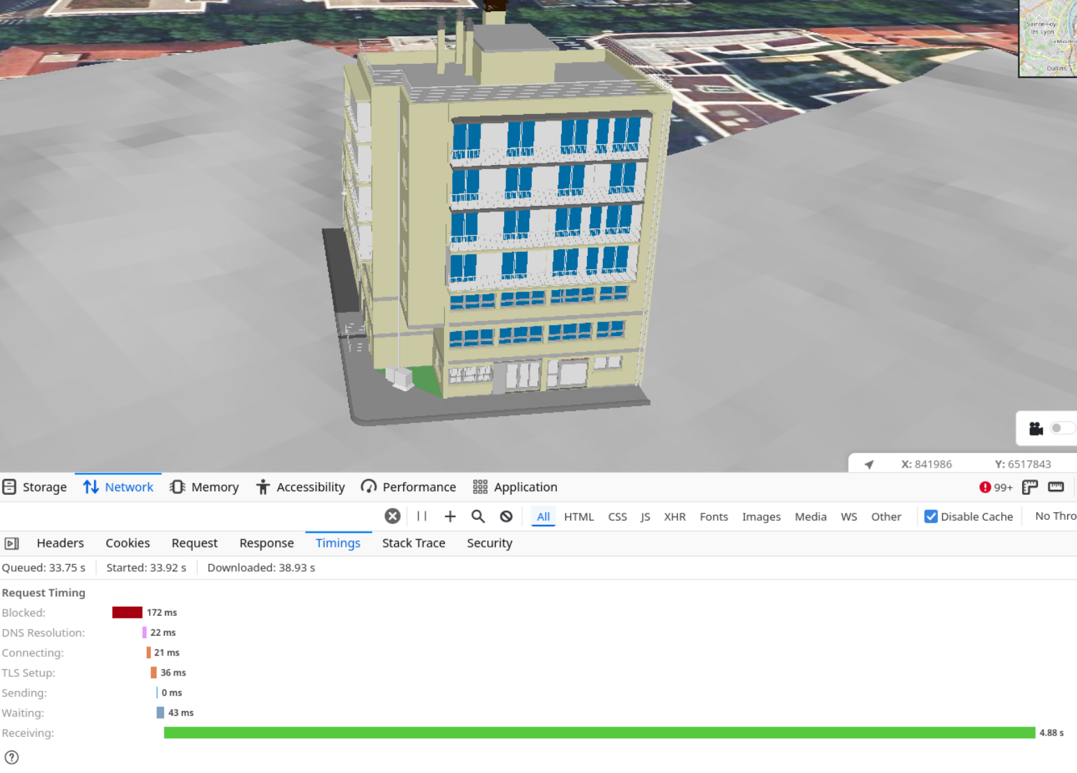
Affichage d’une maquette BIM au format IFC avec Giro3D
En guise de transition avec la partie suivante, dédiée à la segmentation sémantique, on notera également le support de la classification sémantique dans le viewer 3D ( [https:]] ).
Segmentation sémantique 3DEn guise de dernière partie impactante, notons enfin les avancées en matière de segmentation sémantique 3D, qui ont permis à Oslandia de se positionner sur cette technologie via une implémentation de l’algorithme KPConv. Nous avons choisi de travailler à partir de l’implémentation en Pytorch proposée par Hugues Thomas, et lui avons apporté un certain nombre de fonctionnalité pertinentes dans le cadre de IASBIM, via un fork ( [https:]] ). Cela nous a conduit à produire nos premières inférences sur des jeux de données exploités pendant IASBIM ( [https:]] ), ainsi qu’une feuille de route pour les prochaines étapes sur ce sujet !
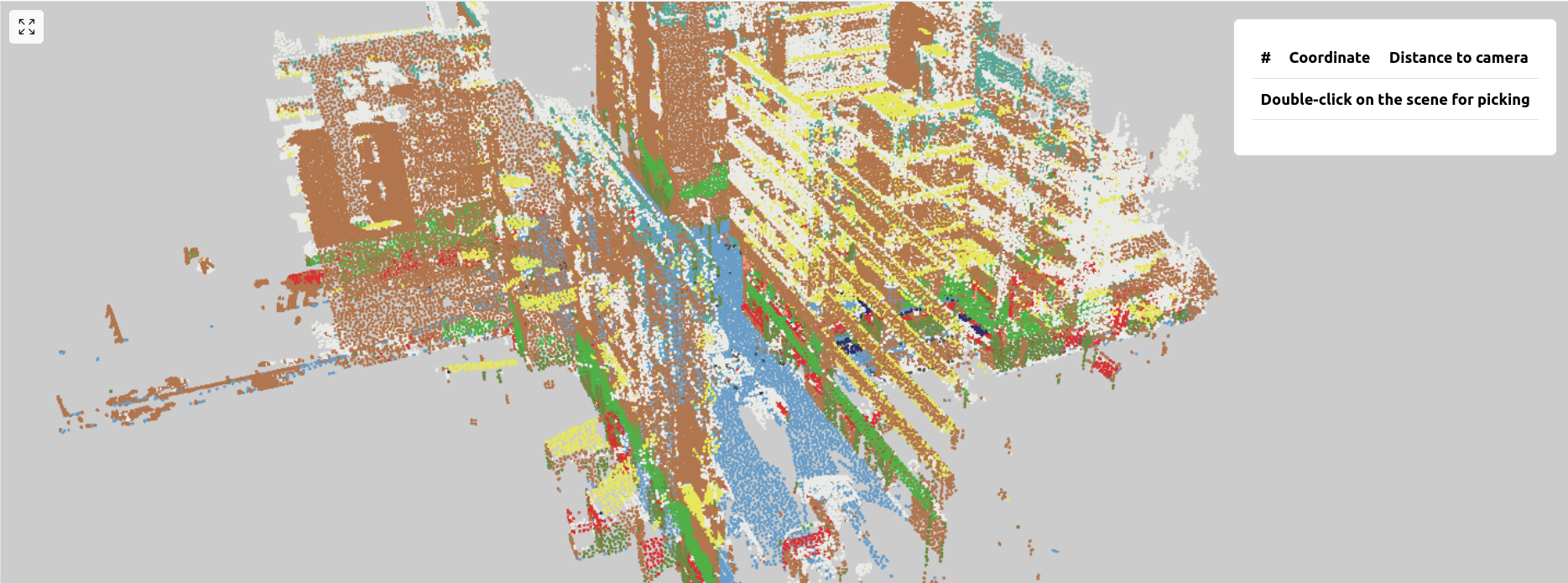
Exemple de prédiction par KPConv en contexte outdoor, on note les murs en marron, le sol en bleu, les avancées de toiture en jaune, notamment
Pour aller plus loinSi vous désirez en savoir plus sur IASBIM, vous pourrez retrouver quelques informations supplémentaires sur le blog dédié au projet ( [https:]] ).
Vous êtes intéressés par les interactions entre modèles 3D et maquettes BIM, ou par la visualisation web de données 3D de manière plus générale ? N’hésitez pas à nous contacter via infos@oslandia.com pour en savoir plus !
-
12:00
Mappery: Tattoo Shop Decor
sur Planet OSGeo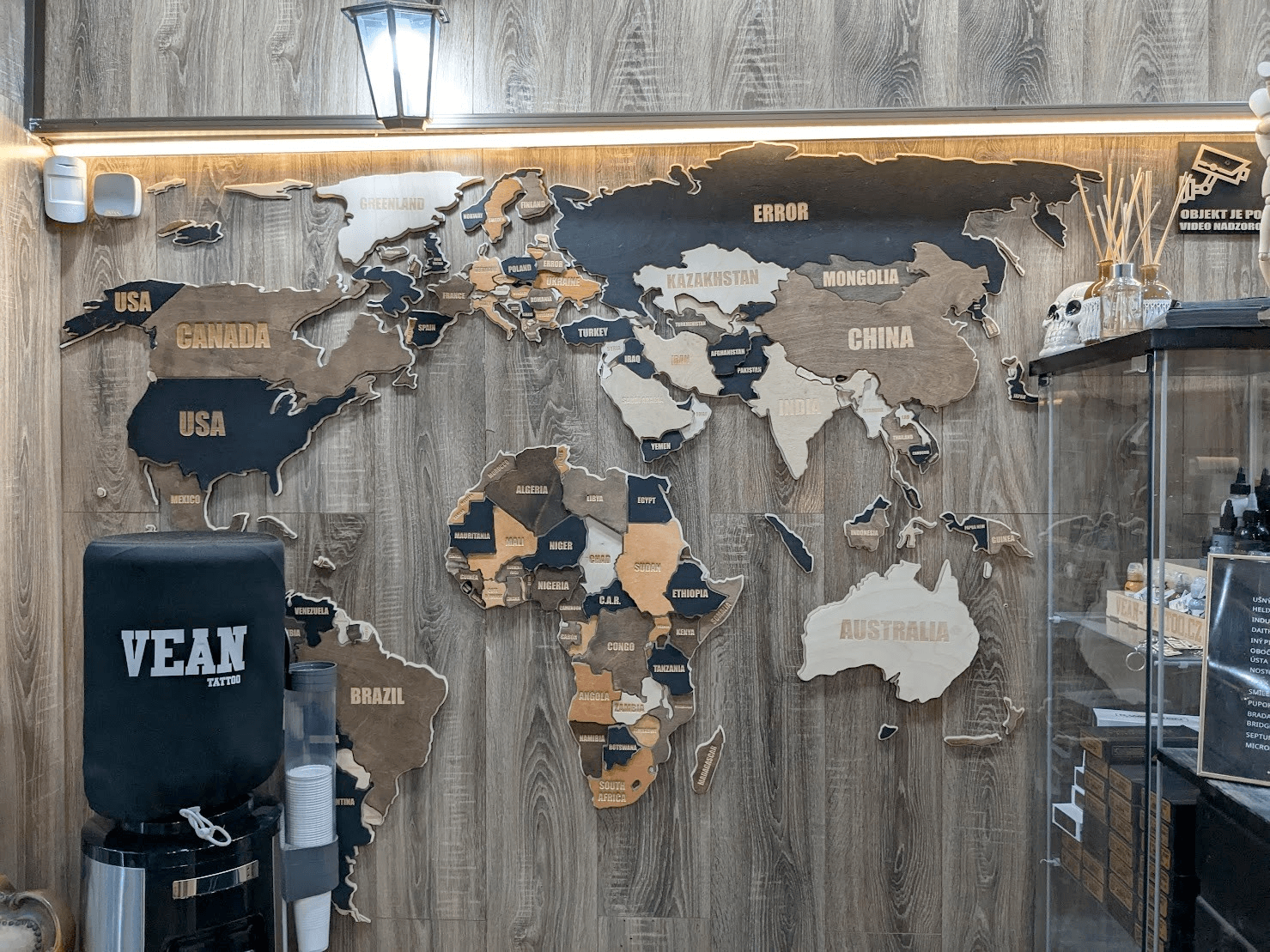

Erik spotted this sort of thematic map in a tattoo shop in Bratislava. I can’t work out the thematic criteria
“Nice #mapsinthewild in a tattoo shop in Bratislava. [https:]] to be exact. Walking past while on the way to the #QGISUC2024 dinner location. Map with New Zealand, but transformation might be a bit off.”
-
12:00
Mappery: Toronto Waterfront
sur Planet OSGeo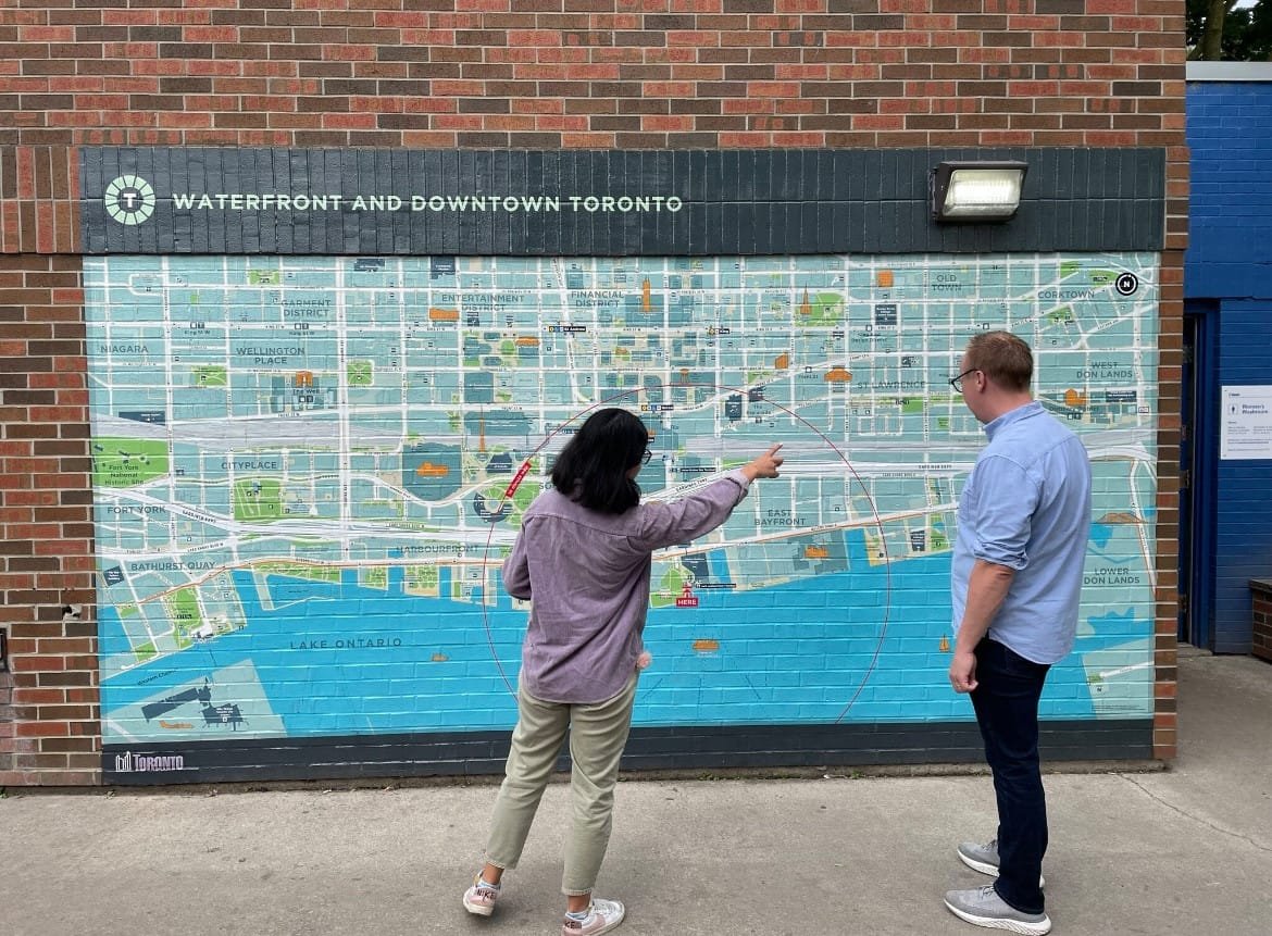

Clare shared this map of Toronto
-
5:11
BostonGIS: The bus factor problem
sur Planet OSGeoOne of the biggest problems open source projects face today is the bus factor problem.
I've been thinking a lot about this lately as how it applies to my PostGIS, pgRouting, and OSGeo System Administration (SAC) teams.
Continue reading "The bus factor problem" -
12:00
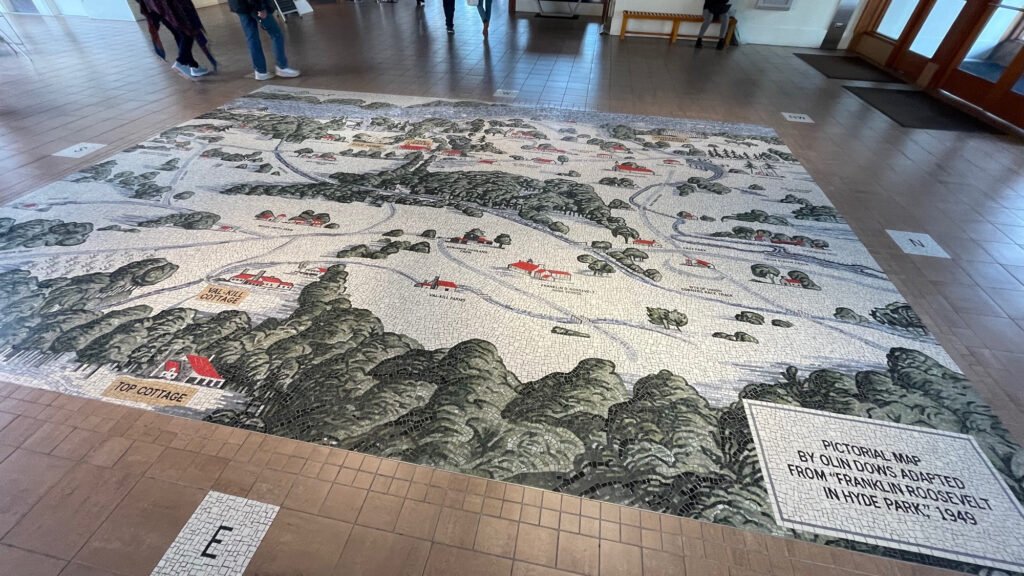
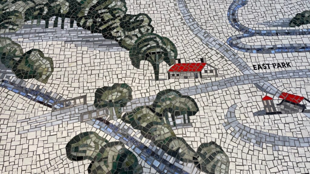
Mappery: The New Deal
sur Planet OSGeo
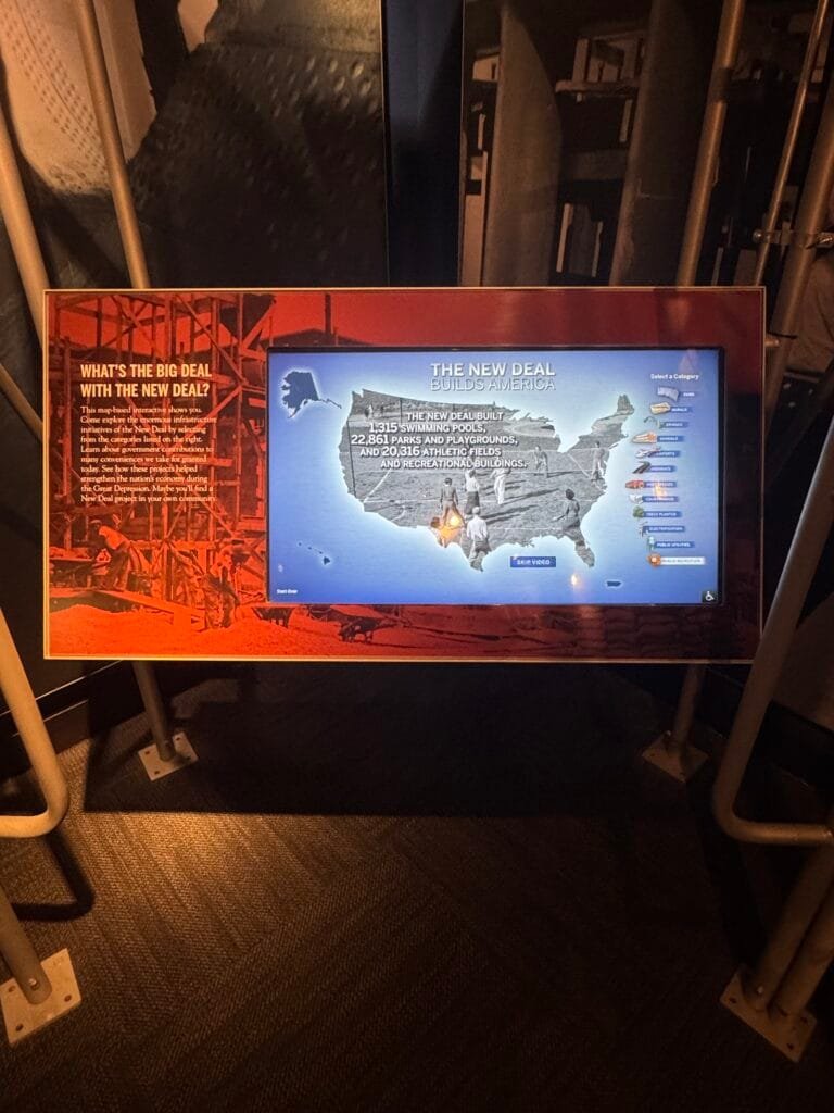
An interactive map from the FDR Museum
“Learn about government contributions to many conveniences we take for granted today. See how these projects helped strengthen the nation’s economy during the Great Depression. Maybe you’ll find a New Deal project in your own community”
-
11:24
QGIS Blog: Plugin Update – November, 2024
sur Planet OSGeoNovember was a really productive month, with a remarkable total of 43 new plugins published in QGIS plugin repository. In addition there are 3 more plugins from October listed here, which somehow were missed, and for that we apologize to their authors.
Here follows the quick overview in reverse chronological order. If any of the names or short descriptions catches your attention, you can find the direct link to the plugin page in the table below:
All Geocoders At Once Plugin accumulating most popular geocoders. ODK Connect Connect to ODK Central, fetch submissions, and visualize field data on QGIS maps. Supports filtering, spatial analysis, and data export. Web Service Plugin Wtyczka umo?liwia prezentacj? danych z serwisów WMS, WMTS, WFS i WCS w postaci warstw w QGIS. Wtyczka wykorzystuje dane z Ewidencji Zbiorów i Us?ug oraz strony geoportal.gov.pl Polygon grouper This plugin groups polygons together. GeoCAR Cadastro Ambiental Rural. Not-So-QT-DEM TauDEM 5.3 processing provider. GeocodeCN ????????????????
EN: A plug-in that converts addresses into latitude and longitude coordinates.Feature Navigator Este plugin permite navegar entre entidades en una capa activa de QGIS con botones de anterior y siguiente. Movement Analysis Toolbox for raster based movement analysis: least-cost path, accumulated cost surface, accessibility. Graphab3 Graphab3 for QGIS. SGTool Simple Potential Field Processing. FieldColorCoder Easily apply color codes to layers based on selected field values. NGP Connect Plugin to store files in Lantmäteriet National Geodata Platform with external storage for the attachment widget in features attribute form. Projection Factors Redux Calculates various cartographic projection properties as a raster layer. ArqueoTransectas Este complemento genera transectas arqueológicas (líneas horizontales o verticales) dentro de un área definida. Puede ser útil para estudios de campo y proyectos arqueológicos. BROnodig Plugin om BRO data te downloaden en plotten. Arches Project A plugin that links QGIS to an Arches project. Field annotations Make annotations and photos in the field. qCEPHEE Plugin QGIS for CEPHEE. Water Network Tools for Resilience (WNTR) Integration A QGIS Plugin for the WNTR piped water network modelling package. Allows the preparation of water network models and visualisation of simulation results within QGIS. FitLoader A simple plugin to import FIT files. EasyDEM Get Digital Elevation Model (DEM) datasets from multiple sources with Google Earth Engine API and load it as raster layer. Si Kataster EN: SiKataster is a tool for accessing cadastral parcel data from the Real Estate Cadastre of the Surveying and Mapping Authority of the Republic of Slovenia (GURS). The plugin is designed to record information about the source and the date of data acquisition into the metadata of the layers it creates. The data and web service are provided by GURS.
SI: SiKataster je orodje za dostop do podatkov o parcelah v Katastru nepremi?nin Geodetske uprave Republike Slovenije (GURS). Vti?nik je zasnovan na na?in, da v metapodatke slojev, ki jih ustvari, zapiše informacije o viru in datumu prevzema podatkov. Podatke in spletni servis zagotavlja GURS.Shred Layer Plugin This plugin allows users to “shred” a layer. Can be used to delete unnecessary layers or when you do not want to leave evidence. Cut layers can also be scattered on the map. otsusmethod This plugin applies Otsu’s method for automated thresholding and segmentation of raster data. Split Lines By Points Split Lines By Points. ??????? ???????????
EN: A collection of functions to implement graphics processingEasy Feature Selector The Easy Feature Selector plugin for QGIS is a practical tool designed to simplify interactions with vector data. GenSimPlot Generator of simulation plots. LockCanvasZoom The Lock and Unlock Canvas Zoom Plugin for QGIS is designed to provide users with a simple way to lock and unlock the zoom position on the map canvas. This plugin offers a toggle button that allows users to easily switch between locked and unlocked states for the map canvas zoom. GWAT – Watershed Analysis Toolbox by Geomeletitiki Semi-automated Hydrological Basin Analysis toolbox. GeoPEC GeoPEC é um software científico para avaliação da acurácia posicional de dados espaciais Esporta Tab su file CSV Esporta la tabella del layer vettoriale selezionato su un file CSV. transform_coords Transform decimal/grade-minute-second coordinates to UTM. Can also make points on the selected coordinates. Geocoder CartoCiudad CartoCiudad ofrece direcciones postales, topónimos, poblaciones y límites administrativos de España. Multi Raster Transparency Pixel Setter Set transparency pixel for multiple raster layers. InSAR Explorer InSAR Explorer is a QGIS plugin that allows for dynamic visualization and analysis of InSAR time series data. Vgrid Vgrid – Global Geocoding Systems. Profile Manager Makes handling profiles easy by giving you an UI to easily import settings from one profile to another. QGIS2Mapbender QGIS plugin to populate Mapbender with WMS services from QGIS Server. PLU Versionning Outil de suivi des versions de numérisation des documents d’urbanisme au format CNIG. Snowflake Connector for QGIS This package includes the Snowflake Connector for QGIS. Count Routes This plugin provides algorithms of network analysis. QuickRectangleCreator QuickRectangleCreator allows you to create a rectangle quickly and easily, preset sizes, snap to grid and rotate on the fly. AlgoMaps PL: Plugin Algolytics do standaryzacji danych adresowych i geokodowania.
EN: Algolytics Plugin for Address Data Standardization and Geocoding.Kue Kue is an embedded AI assistant inside QGIS. -
14:08
gvSIG Batoví: Añadimos una nueva publicación para consulta
sur Planet OSGeo -
14:01
SIG Libre Uruguay: Nuevo libro: «La amenaza mundial de la sequía: tendencias de aridez a nivel regional y mundial, y proyecciones futuras»
sur Planet OSGeo
Compartimos un nuevo libro de sumo interés elaborado por la Convención de las Naciones Unidas de Lucha contra la Desertificación (CNULD). El mismo cuenta con numerosa información geoespacial, muy útil para una gran variedad de campos de investigación.
-
12:00
Mappery: Election Results
sur Planet OSGeo
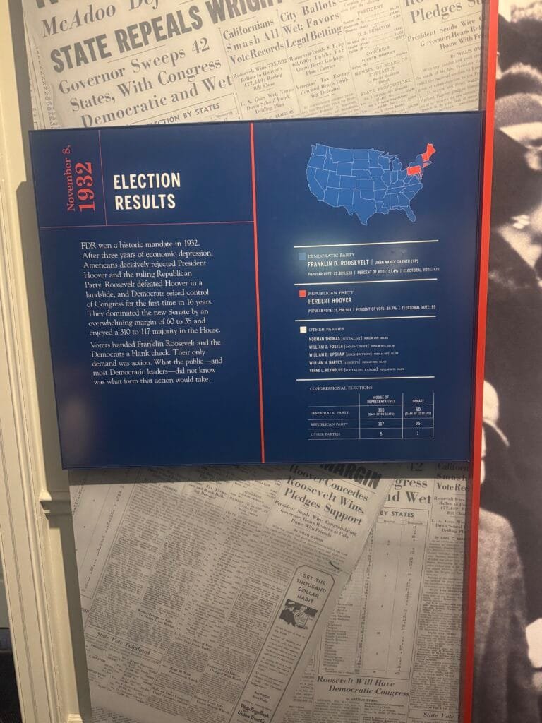
Saw this election results map at the FDR Museum a couple of days before the 2024 US Election. This is what I would call an overwhelming vote for one candidate!
The blurb says
“FDR won a historic mandate in 1932.
After three years of economic depression, Americans decisively rejected President Hoover and the ruling Republican Party. Roosevelt defeated Hoover in a landslide, and Democrats seized control of Congress for the first time in 16 years.
They dominated the new Senate by an overwhelming margin of 60 to 35 and enjoyed a 310 to 117 majority in the House.
Voters handed Franklin Roosevelt and the Democrats a blank check. Their only demand was action. What the public-and most Democratic leaders-did not know was what form that action would take.”You could reword this to fit today’s circumstances.
-
12:00
Mappery: Redlining
sur Planet OSGeo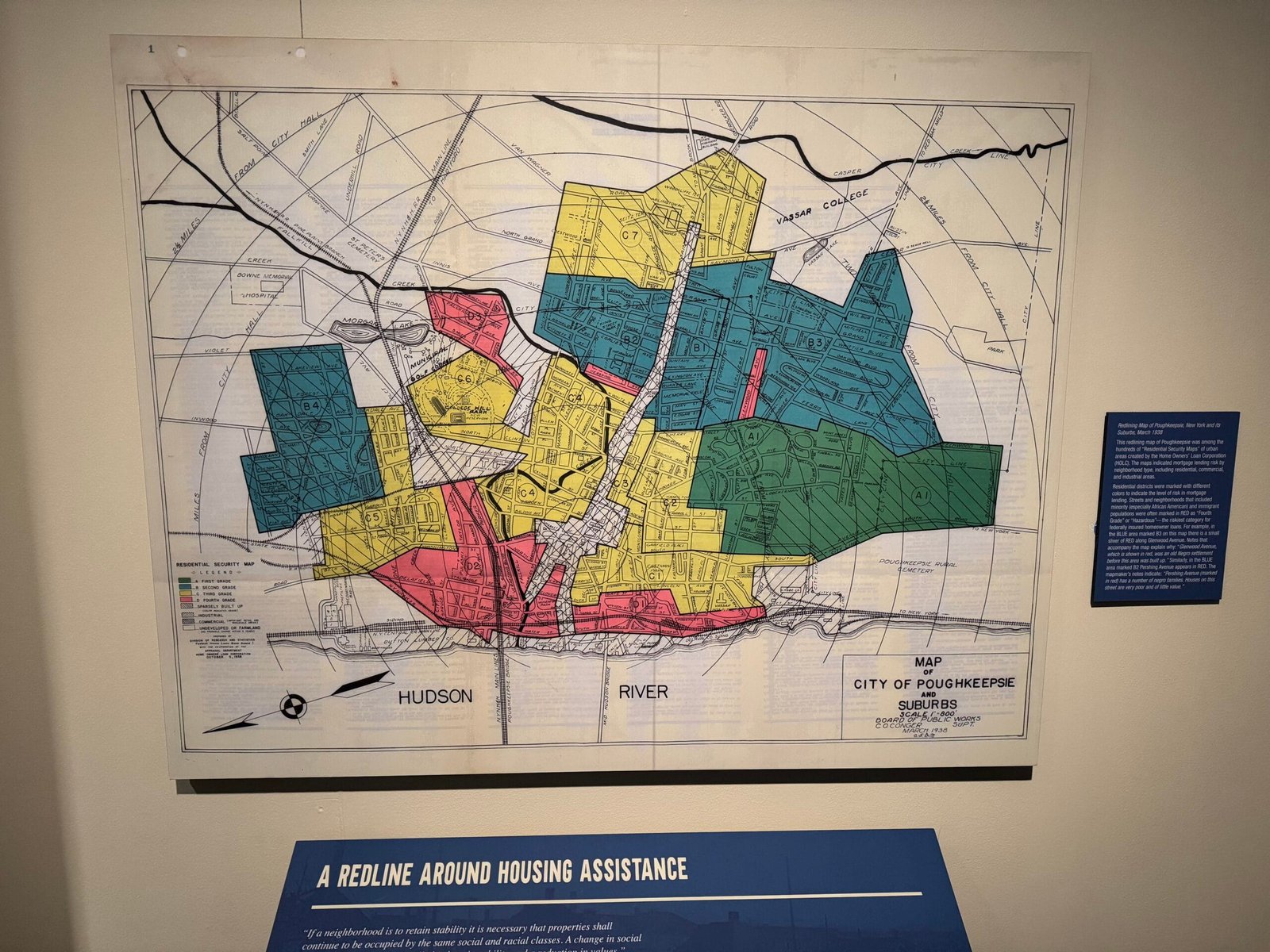

I spotted this map in Franklin Delano Roosevelt Museum, which had a special exhibition on FDR and Black African Americans.
Redlining Map of Poughkeepsie, New York and its Suburbs, March 1938
This redlining map of Poughkeepsie was among the hundreds of “Residential Security Maps” of urban areas created by the Home Owners’ Loan Corporation.The maps indicated mortgage lending risk by neighborhood type, including residential, commercial, and industrial areas. Residential districts were marked with different colors to indicate the level of risk in mortgage lending. Streets and neighborhoods that included minority (especially African American) and immigrant populations were often marked in RED as “Fourth Grade” or “Hazardous”— the riskiest category for federally insured homeowner loans. For example, in the BLUE area marked B3 on this map there is a small sliver of RED along Glenwood Avenue. Notes that accompany the map explain why: “Glenwood Avenue, which is shown in red, was an old Negro settlement before this area was built up.” Similarly, in the BLUE area marked B2 Pershing Avenue appears in RED. The mapmaker’s notes indicate: “Pershing Avenue (marked in red) has a number of negro families. Houses on this street are very poor and of little value.”
Not a lot seems to have changed!
-
7:57
Les effets atmosphériques avec Giro3D
sur OslandiaPièce jointe: [télécharger]
Cet article concerne des fonctionnalités en cours de développement et sujettes à évolution.
Dans le cadre du développement du mode globe de Giro3D (voir notre article à ce sujet), voyons de plus près les effets atmosphériques proposés en complément de la nouvelle entité Globe: Glow, Atmosphere et SkyDome.
L’entité Glow Ces trois entités sont totalement indépendantes de l’entité Globe (et de toutes les autres entités de Giro3D) et peuvent donc être utilisées dans des scènes ne comportant aucun globe (par exemple en remplaçant les globes par de simples sphères colorées).
Cette entité permet de représenter un simple halo lumineux sphérique. Il permet de représenter un objets émettant de la lumière (comme le Soleil), ou bien une atmosphère très simplifiée (en terme de puissance de calcul graphique requise). Elle n’est pas sensible à l’éclairage de la scène.
Création d'un halo lumineux de la taille du soleilconst SUN_RADIUS = 696_340_000; const glow = new Glow({ color: '#ff7800', ellipsoid: Ellipsoid.sphere(SUN_RADIUS), });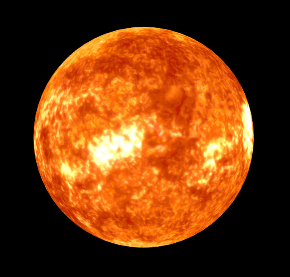
Le globe du soleil seul
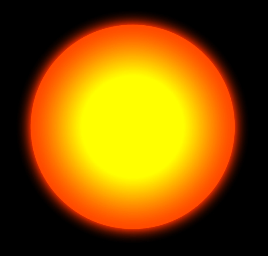
Le halo du soleil seul

Globe et halo combinés
L’entité AtmosphereCette entité permet de représenter fidèlement une atmosphère vue de l’espace. Elle requiert une position du soleil pour fonctionner, via la méthode
Atmosphere.setSunPosition().
Création d'une atmosphère autour de la terreconst atmosphere = new Atmosphere({ ellipsoid: Ellipsoid.WGS84 }); const sunLatitude = 5; const sunLongitude = 45; const sunPosition = Ellipsoid.WGS84.toCartesian( sunLatitude, sunLongitude, 50_000_000, ); atmosphere.setSunPosition(sunPosition);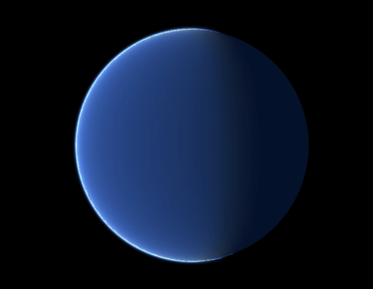
L’entité Atmosphere combinée à une simple sphère bleue
Une fois combiné avec un Globe paramétré avec des couches images appropriées, voici le résultat:
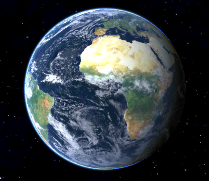
Globe terrestre et atmosphère combinés
L’entité SkyDomeCette dernière entité est le pendant de l’entité Atmosphere, mais vu depuis l’intérieur. Elle permet de représenter la diffusion Rayleigh, c’est à dire la diffusion des rayons du soleil dans le ciel (ce qui donne sa couleur au ciel). Le disque solaire est également représenté avec fidélité selon la position apparente du soleil par rapport à l’horizon.
Ajout d'un _Skydome_ à l'instance Giro3Dconst skyDome = new SkyDome(); instance.add(skyDome); atmosphere.setSunPosition(sunPosition);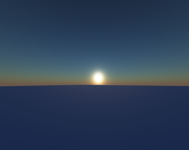
Un crépuscule
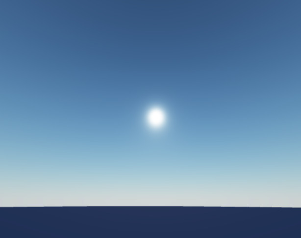
Une heure plus avancée
ConclusionCombinées aux éclairages dynamiques et aux ombres portées, ces trois nouvelles entités permettront aux utilisateurs de créer de belles scènes réalistes, de l’échelle locale à celle du système solaire.
-
12:00
Mappery: Standing on New York State
sur Planet OSGeo
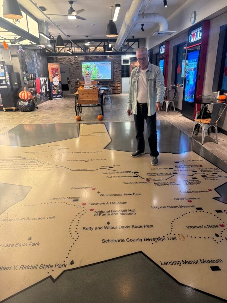
We stopped at a rest stop on our way south through New York State, you know I love a floor map! This one shows parks and museums in the state. I agree with the signs saying “I love NY”

-
16:22
Le blog de Geomatys: Stages 2025 !
sur Planet OSGeo Stages Geomatys pour 2025
- 10/12/2024
- Jordan Serviere
Geomatys propose pour 2025 deux nouvelles offres de stages :
 Montpellier – 3 à 6 mois
Traitement de données géospatiales pour un outil cartographique de prédictions de risques d’émergence de maladies infectieuses
Learn moreMontpellier – 3 à 6 mois Entre mars et septembre 2025
Développement d’un algorithme de Machine Learning pour la prévision des pics de turbidité
Learn more Menu Linkedin
Twitter
Youtube
Linkedin
Twitter
Youtube

The post Stages 2025 ! first appeared on Geomatys.
-
14:00
Fernando Quadro: WebGIS sob Medida
sur Planet OSGeoWebGIS é uma tecnologia usada para exibir e analisar dados espaciais na Internet. Ele combina as vantagens da Internet e do GIS oferecendo um novo meio de acessar informações espaciais sem a necessidade de você possuir ou instalar um software GIS.
A necessidade de divulgação de dados geoespaciais têm estimulado cada vez mais o uso de ferramentas WebGIS para apresentações interativas de mapas e de informações relacionadas por meio da internet.
As soluções adotadas na apresentação destes mapas devem apresentar um equilíbrio entre facilidade de uso, riqueza de recursos para visualização e navegação entre os dados, e funcionalidades geoespaciais para pós processamento, características que devem ser adequadas para cada perfil de usuário que acessará o WebGIS.
Se você e sua empresa possuem dados geoespaciais e querem disponibilizá-las na Web, o caminho natural para isso é o desenvolvimento de um WebGIS. Mas, se você não tiver uma equipe de TI, ou um especialista em desenvolvimento GIS, não se preocupe, a Geocursos pode te ajudar.
Nossa experiência em GIS nos habilita a entregar soluções baseadas nessa tecnologia utilizando ferramentas open source de visualização geográfica aliada a soluções criativas para o seu negócio.
Quem saber mais?Acesse e peça um orçamento: [https:]]
WhatsApp: [whats.link] -
12:00
Mappery: Clock Map
sur Planet OSGeo
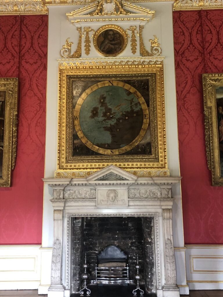
BarryRuderman of Raremaps.com shared this with us “Check out the anemoscope at Kensington Palace dating back to the reign of William III. #mapsinthewild #maps
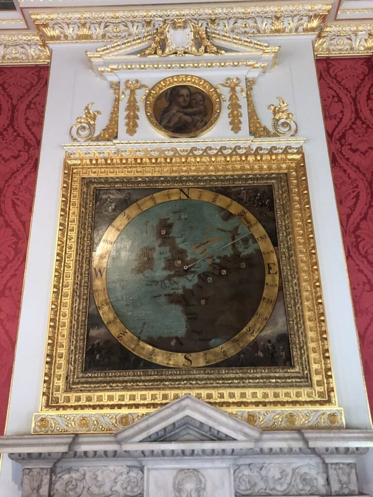
I love that London appears as the centre of the world (well Europe at least)
-
11:00
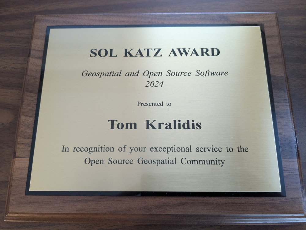
OSGeo Announcements: [OSGeo-Announce] Tom Kralidis receives the 2024 Sol Katz Award
sur Planet OSGeoTom Kralidis was honoured with the 2024 Sol Katz Award, presented on 6 December 2024 at FOSS4G 2024 in Belém, Brazil.
This was the 20th year of the award.
2024-12-09

We are honoured to announce that Tom Kralidis is the recipient of the 2024 Sol Katz Award.
You may know Tom through his activities within the GeoPython community, specifically through pygeoapi, pycsw, OWSLib, GeoHealthCheck, pygeometa, and the list goes on. Tom also plays a critical role in promoting OGC standards, throughout FOSS4G projects and also connecting the OGC + OSGeo communities.
Tom is very active at the OSGeo Board level, and other committees within the foundation. He is also active in the World Meteorological Organization (WMO).
But you will most likely know him from various FOSS4G workshops around the world, where he helps users share their spatial information through known standards and Open Source software.
Tom Kralidis is a longtime leader in the FOSS4G community, and it warms our heart to finally thank him for his decades of tireless effort, in promoting sharing.
The FOSS4G community is full of people doing amazing work, and today we take a moment to shine the spotlight on one person, who has long deserved a thank-you, Tom Kralidis.
Thanks Tom!
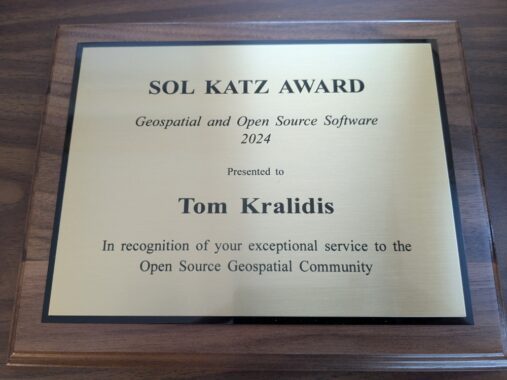
About the award
The Sol Katz Award for Free and Open Source Software for Geospatial (FOSS4G) is awarded annually by OSGeo to individuals who have demonstrated leadership in the FOSS4G community. Recipients of the award have contributed significantly through their activities to advance open source ideals in the geospatial realm. The award acknowledges both the work of community members, and pay tribute to one of its founders, for years to come.
Read more about Sol Katz at Awards

1 post - 1 participant
-
20:52
gvSIG Batoví: 3 LIBROS ACTUALES E IMPRESCINDIBLES
sur Planet OSGeo -
14:00
Fernando Quadro: 12 características de um Profissional GIS
sur Planet OSGeoNo cenário geoespacial em rápida evolução de hoje, ser um profissional de GIS é mais do que apenas trabalhar com mapas e dados.
Requer uma mistura única de conhecimento técnico, pensamento crítico, criatividade e colaboração.
Quer você esteja apenas começando ou seja um especialista experiente, essas 12 características essenciais podem ajudá-lo a se destacar e prosperar na indústria geoespacial.
Conhecimento em tecnologia
Atenção aos detalhes
Comunicador eficaz
Estar sempre aprendendo
Orientado por dados
Colaborativo
Gerente de projeto
Pensador crítico
Apaixonado por geografia
Solucionador criativo de problemas
Tomador de decisões
Pensador analíticoQual dessas características você acredita ser a mais importante para o sucesso em GIS? Conte nos comentários!
Fonte: webgis.tech
Instagram: [https:]]
LinkedIn: [https:]] -
12:00
Mappery: Bike Race
sur Planet OSGeo
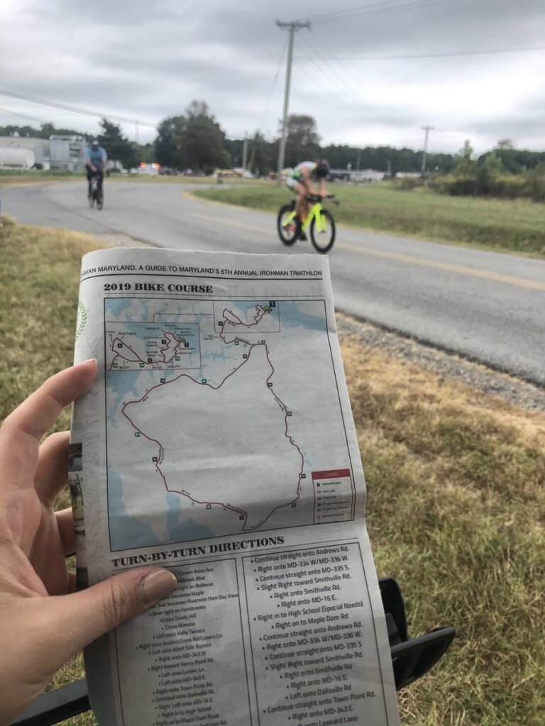
MaddieCaraway shared this “#MapsInTheWild- Navigating the bike course while I chase my dad @CarawayJd doing an @IRONMANtri!!
-
12:00
Mappery: Aberfan
sur Planet OSGeo

Nick Clark shared these Gatepost-style memorial to the houses which stood where Heilbronn Way now looms over Aberavon #MapsIntheWild

-
5:55
Sean Gillies: Late fall biking
sur Planet OSGeoI've decided to try to ride a bike for exercise more in 2025. Run harder, but run less, with more active recovery and low-intensity outings on a bike. At least until June, when I need to start building the running and hiking endurance that I will need in September.
I got a new bike to make this more fun. It's a Rocky Mountain Solo C50 and I bought it from my favorite local bike shop, Drake Cycles, last Saturday. The first thing I did was pedal it from home up Spring Creek Trail to Pineridge Open Space and ride some laps around the pond. It sure beats riding my commuter bike on dirt and gravel. I haven't bought a new bike or any new bike components in 10 years. Electronic shifters feel like magic to me.

A dark blue-green bike with wide drop handlebars leaning on an interpretive sign in a dry valley under and overcast sky.
So far this week I've done two rides from the barn where we keep our horses while Bea has been doing her equestrian stuff. One at sunset and one at sunrise. I've been three miles east of the barn and seven miles north of the barn, following roads on the PLSS section grid.

A dirt road at dusk, headlights of an approaching truck, and orange sunset glow behind the Rocky Mountains.
In the neighborhood of the barn, the ground is completely free of snow and quite dry. Passing trucks raise medium density clouds of dust. There are scattered homes out here, and vehicles going to and fro periodically. There are large construction sites, too, which can mean a wave of large rigs pulling trailers.

A rolling dirt road and brown grassland with snow-dusted mountains in the background.
I've got a lot to learn about this kind of riding. The right tire pressure for road and trail conditions, for example, and how to get in and out of the drops smoothly. How to descend and corner safely, and how to survive washboard surfaces. Dressing, too. I'm riding at a low intensity and don't generate as much heat as I do when I run.
One of my favorite things about riding further east is the panoramic views of the Front Range peaks. I can see Pikes Peak, Mount Evans, Longs Peak, and the Mummy Range, a span of 200 kilometers, from the top of every rise.
-
22:53
Sean Gillies: Productive running
sur Planet OSGeoAt last, I'm less than 1% injured and am getting back into regular and productive running. We've had a long stretch of mild and dry weather here, which makes it easy to just lace up and go. I ran four times last week, including a nice hilly run in Lory State Park, and will run three times this week. Thursday I did some harder running and a bunch of strides for the first time since June.
Some faint numbness lingers on my left quad, but my hip, butt, and leg are otherwise just fine. My doctor prescribed a course of prednisolone in early November to calm down my pinched nerve and that seemed to banish the last of my Achilles tendonitis as well. My right heel and calf haven't been pain-free in a long time. It's really nice to feel good.

Shoes, legs, and shorts in warm December sunshine
-
12:00
Mappery: New Hampshire – The Wooden State
sur Planet OSGeo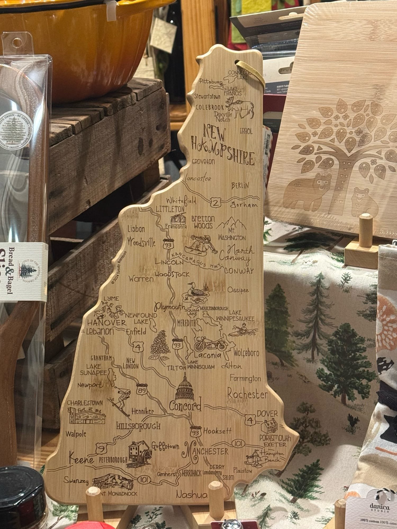

I spotted this neat wooden cheeseboard in the shape of New Hampshire in Portsmouth at the beginning of our road trip through New England.
-
18:05
SIG Libre Uruguay: 3 LIBROS ACTUALES E IMPRESCINDIBLES
sur Planet OSGeoCompartimos 3 libros que nos parecen de sumo interés para la comunidad:


-
12:00
Mappery: Goose Creek
sur Planet OSGeo

Corvus sent us this 3D relief map at the Goose Creek rest area in Minnesota. Looks pretty big to me
-
11:05
WhereGroup: Datenschutzkonforme Bildveröffentlichung: Gesichter und Nummernschilder automatisch verpixeln mit Python
sur Planet OSGeoAutokennzeichen und Gesichter verpixeln und datenschutzkonforme Bilder erstellen mit Python in nur wenigen Schritten. Wir zeigen wie’s geht. -
2:00
SourcePole: FOSS4G 2024 Belém
sur Planet OSGeoFOSS4G is the annual global event of free and open source geographic technologies and open geospatial data hosted by OSGeo. In 2024 it took place in Belém, Brasil.
-
14:00
Fernando Quadro: 10 aplicações GIS em Energias Renováveis
sur Planet OSGeoÀ medida que o mundo transita para um futuro energético mais limpo e sustentável, o papel dos Sistemas de Informação Geográfica (GIS) se tornou indispensável.
O GIS nos permite enfrentar os desafios complexos do desenvolvimento de energia renovável com precisão e eficiência.
Seja identificando os principais locais para fazendas solares, avaliando o potencial de energia eólica ou planejando infraestrutura hidrelétrica, o GIS fornece os insights espaciais necessários para tomar decisões informadas.
Além do planejamento de projetos, o GIS oferece suporte a avaliações ambientais, mitiga riscos e ajuda a integrar energia renovável em redes elétricas, garantindo que esses desenvolvimentos sejam sustentáveis e resilientes.
Ele também capacita provedores de energia e formuladores de políticas a envolver comunidades, reduzir emissões e enfrentar as mudanças climáticas de frente.
Aqui estão 10 maneiras principais pelas quais o GIS está moldando o setor de energia renovável, promovendo inovação e impulsionando mudanças impactantes:
Integração da Rede
Avaliação de Recursos
Avaliação de Impacto Ambiental
Engajamento da Comunidade
Análise de Risco
Monitoramento e Manutenção
Análise de Uso do Solo
Planejamento de Infraestrutura Energética
Mitigação de Mudanças Climáticas
Mapeamento de Demanda EnergéticaGostou desse post? Conte nos comentários

Fonte: webgis.tech
Instagram: [https:]]
LinkedIn: [https:]] -
12:00
Mappery: van Eesteren
sur Planet OSGeo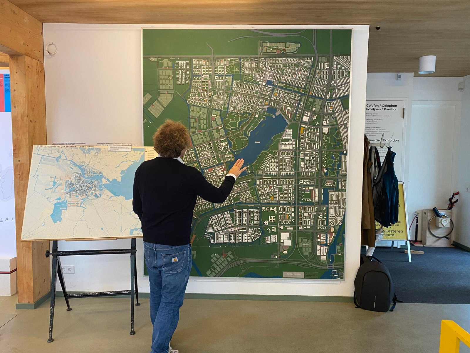
Reinder shared this pic from his visit to the van Eesteren Pavilion at a museum in Amsterdam dedicated to the Dutch architect Van Eesteren (1897-1988). Looks like someone is getting “hands on”
-
10:55
OTB Team: Look back on the OTB Users Days 2024
sur Planet OSGeoThe OTB Users Days 2024 were held on November 21th and 22th at Artilect Fablab in Toulouse. Thanks to everyone who attended the event! Plenary Talks On Thursday several talks were given on various subjects: On Friday morning, we had a presentation of the PLUTO portal (video) Brainstorming session On Thursday and Friday afternoons, we […] -
14:00
Fernando Quadro: WebGIS para monitoramento de Terras Indígenas
sur Planet OSGeoTerras indígenas, como a tribo Alto Turiaçu no Maranhão, enfrentam ameaças crescentes de incêndios florestais. Para ajudar na proteção dessas áreas, a Jéssica Uchoa criou uma aplicação WebGIS que monitora focos de incêndio e analisa seus impactos com dados geoespaciais em tempo real e históricos.
Como funciona: FIRMS (NOAA-21) Realizar o monitoramento de focos de incêndio em tempo real (últimas 24h); Sentinel-2: Análise de cicatrizes de queimadas com imagens de alta resolução; MIRBI: Identificação de pontos ativos de incêndio; Camadas do IBGE: Fornece a localização de territórios indígenas, ajudando na orientação e no planejamento das análises.Você pode acessar uma versão do WebGIS no seguinte link: [https:]
Gostou desse post? Conte nos comentários
Fonte: webgis.tech
Instagram: [https:]]
LinkedIn: [https:]] -
12:00
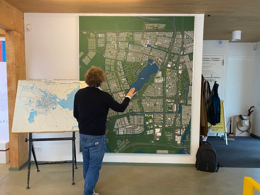
Mappery: Cité de l’espace
sur Planet OSGeo
Camille found a map in a Mir space station module displayed at the Cité de l’espace, Toulouse, France.
-
2:00
Camptocamp: Camptocamp and IGN Partnership Wins 2024 Acteurs du Libre Award for Best Public-Private Collaboration
sur Planet OSGeoPièce jointe: [télécharger]
We’re delighted to announce that Camptocamp, alongside our partner IGN (Institut National de l'Information Géographique et Forestière), has been awarded the prestigious 2024 Acteurs du Libre Prize in the category of Best Public-Private Collaboration. -
20:18
Fernando Quadro: Segredos para desenvolver seu WebGIS
sur Planet OSGeoVocê está enfrentando problemas no desenvolvimento do seu WebGIS?
Deixe-me poupar algum tempo da sua frustração, pois você pode estar cometendo alguns erros comuns:
 Pular direto para a codificação sem um roteiro
Seguir tutoriais que só fazem sentido se você já tiver conhecimento dos termos do WebGIS
Tentar construir ferramentas sem entender o fluxo de dados no WebGIS
Perder tempo “ajustando” ferramentas sem ter a mínima ideia de onde o código deveria ficarParece familiar?
Vou te contar alguns “segredos” para o desenvolvimento do seu WebGIS:
Entenda o fluxo de dados e os termos essenciais
Saiba exatamente quais elementos de programação são essenciais
Domine o uso das bibliotecas WebGIS para obter exatamente o que precisavaGostou desse post? Conte nos comentários
Fonte: webgis.tech
Instagram: [https:]]
LinkedIn: [https:]] -
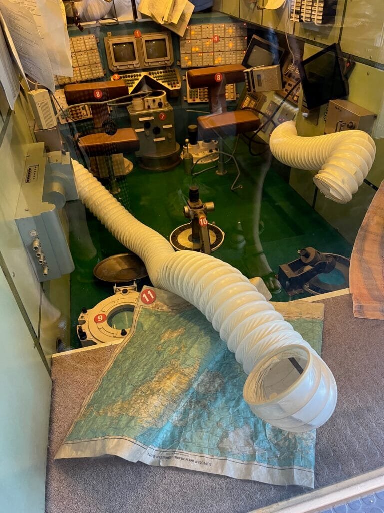
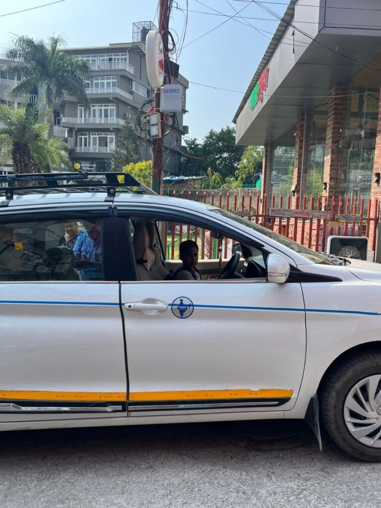
11:00
Mappery: Indian Taxi
sur Planet OSGeo

Elizabeth spotted this Map in the Wild on her travels in India
 FR
FR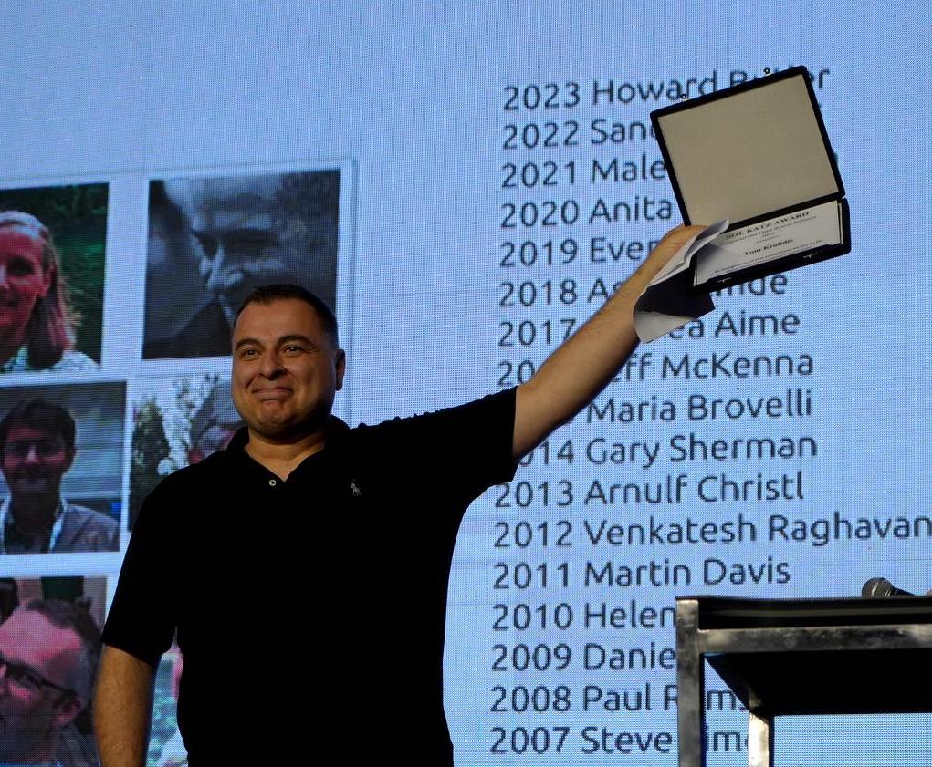
-
7:17
(En) [Story] Oslandia x QWC : épisode 7 / 8
sur Oslandia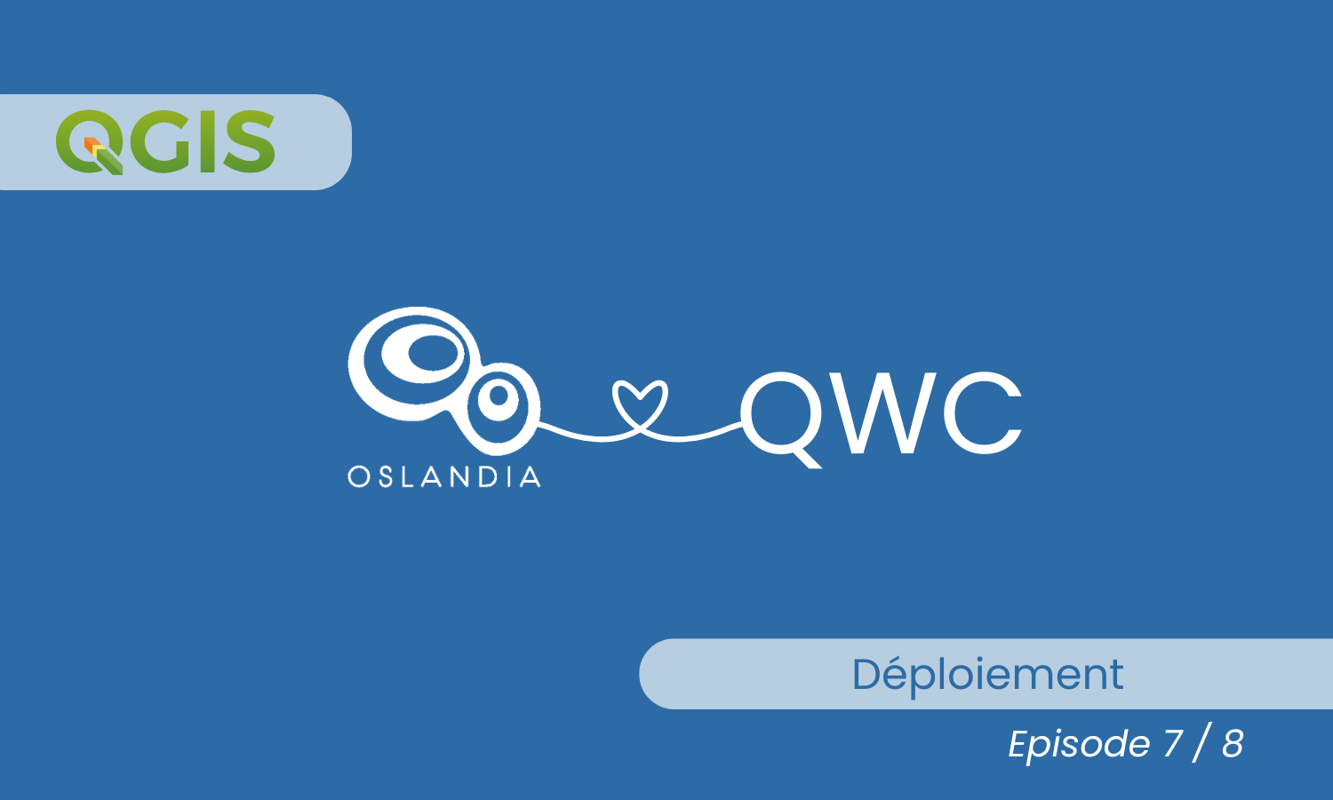
Désolé, cet article est seulement disponible en Anglais Américain.
-
2:00
Camptocamp: Exploring Innovation: Camptocamp at Open Source Experience 2024
sur Planet OSGeoPièce jointe: [télécharger]
As a committed contributor to the Open Source Ecosystem, we look forward to presenting two talks that highlight how these technologies address real-world challenges and drive meaningful solutions. -
12:00
Mappery: Slovenia beer map
sur Planet OSGeo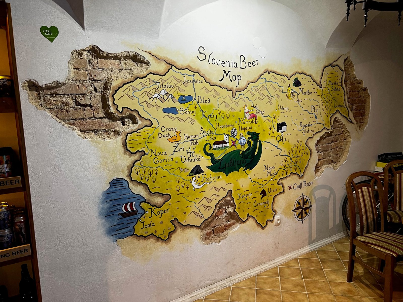

I found this map while visiting a craft beer place named Craft Room, in Ljubljana, Slovenia
-
0:59
BostonGIS: PostGIS Day 2024 Summary
sur Planet OSGeoPostGIS Day yearly conference sponsored by Crunchy Data is my favorite conference of the year because it's the only conference I get to pig out on PostGIS content and meet fellow passionate PostGIS users pushing the envelop of what is possible with PostGIS and by extension PostgreSQL. Sure FOSS4G conferences do have a lot of PostGIS content, but that content is never quite so front and center as it is on PostGIS day conferences. The fact it's virtual means I can attend in pajamas and robe and that the videos come out fairly quickly and is always recorded. In fact the PostGIS Day 2024 videos are available now in case you wanted to see what all the fuss is about.
Continue reading "PostGIS Day 2024 Summary" -
11:00
Mappery: Christmas season begins
sur Planet OSGeo
Raremaps.com (Barry Ruderman) spotted the Christmas decoration at Heceta Head Lighthouse on the Oregon Coast
-
12:00
Mappery: Wait, is it Halloween?
sur Planet OSGeoPièce jointe: [télécharger]
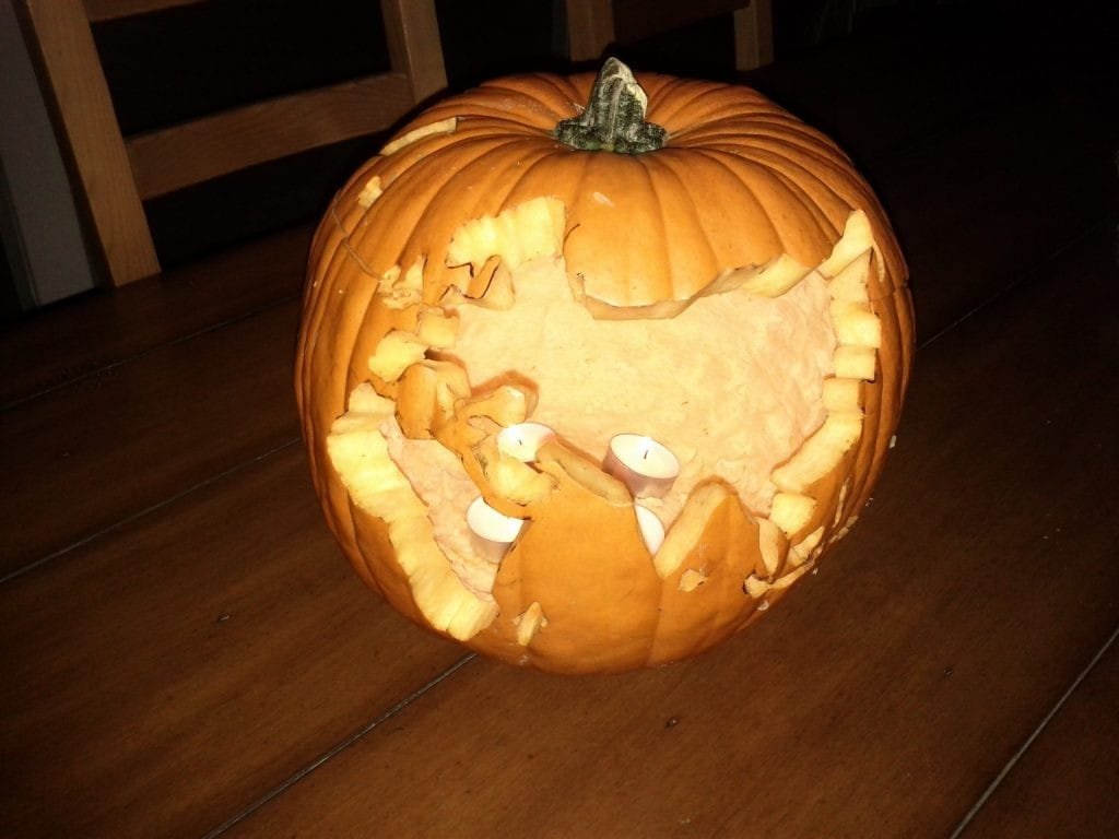
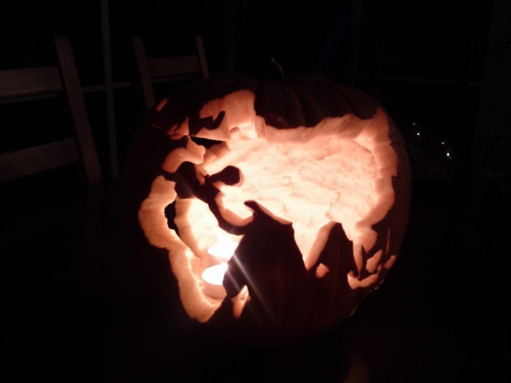
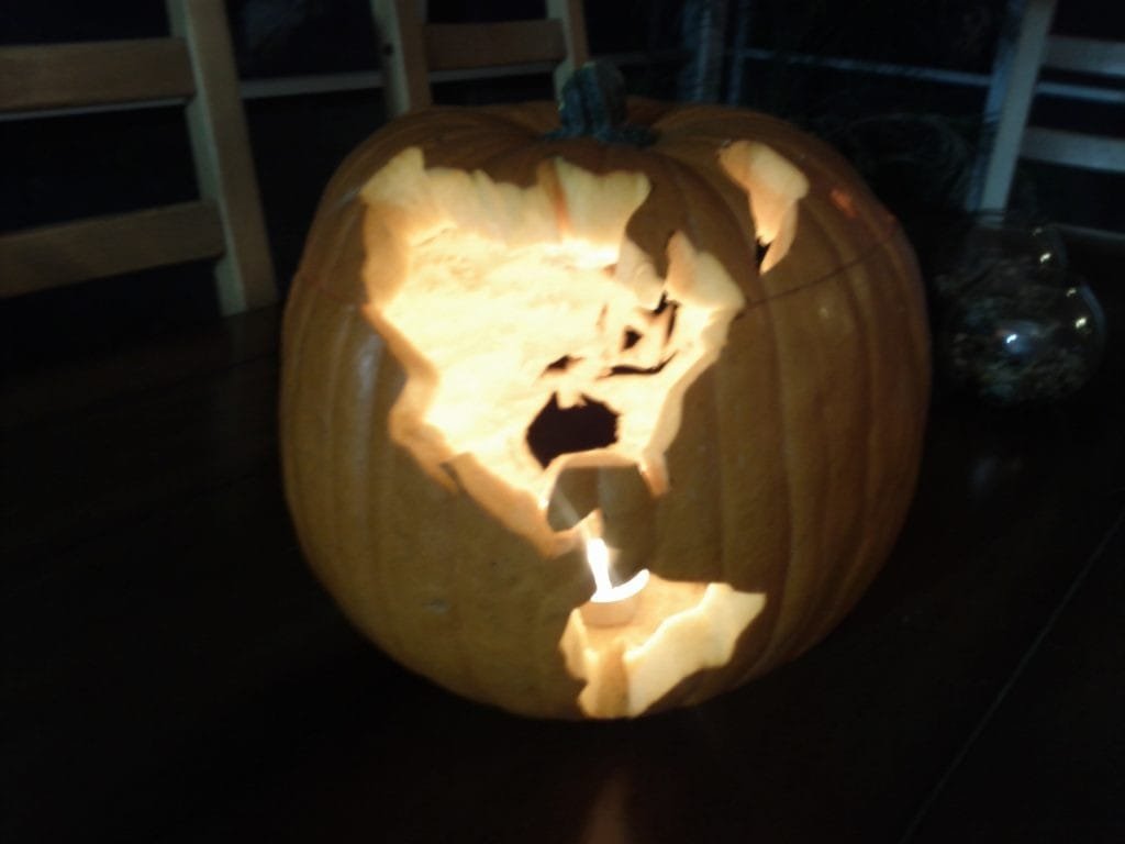
Ken Field once carved a pumpkin, but, of course, it was a globe. It was from Halloween a few years ago.
-
12:00
Mappery: Franklin D. Roosevelt Presidential Library and Museum
sur Planet OSGeo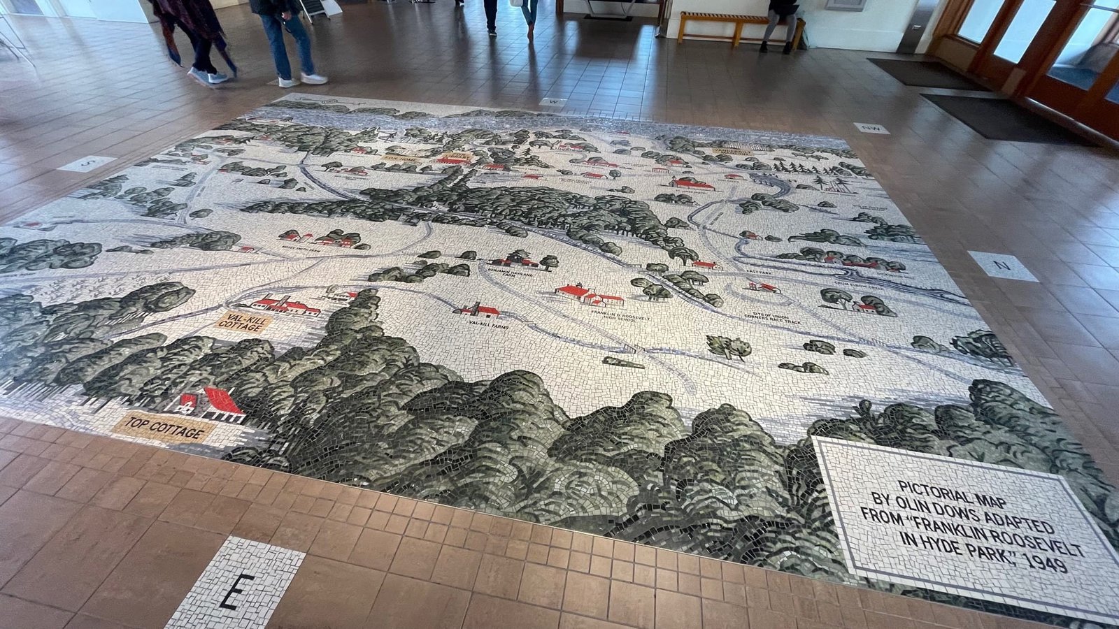
?Rick Lederer-Barnes shared this photos from the Franklin D. Roosevelt Presidential Library and Museum
-
12:00
Mappery: WGS84
sur Planet OSGeoPièce jointe: [télécharger]

Javier Jimenez Shaw shared this mappy licence plate
-
7:47
Eclairez vos terrains avec Giro3D
sur OslandiaPièce jointe: [télécharger]
Cet article concerne des fonctionnalités en cours de développement et sujettes à évolution.
L’éclairage dans Giro3DL’éclairage est un élément déterminant dans une scène 3D, et permet d’améliorer la lisibilité des volumes et du relief, notamment du terrain.
Giro3D dispose de deux modes d’éclairage pour les terrains: simplifié et réaliste.
L’éclairage simplifié (hillshading) Ce mode d’éclairage n’est compatible qu’avec l’entité Map dans un système de coordonnées projeté.Il s’exprime par un couple de valeurs (azimut, zénith) décrivant la position du soleil telle que perçue depuis le centre de la scène. C’est un mécanisme très similaire à celui proposé par QGIS par exemple.
L’avantage de ce système est qu’il est très simple d’emploi, et familier des utilisateurs d’outils cartographiques.
Son inconvénient majeur, en revanche, est qu’il ne fonctionne pas avec le mode globe, puisque l’axe des rayons du soleil n’est pas le même en tout point du globe (alors qu’il l’est en tout point d’une carte plane).
Son autre inconvénient est l’absence de support de multiples sources lumineuses ainsi que les ombres portées.
Une couche d’élévation sans éclairage actif
La même couche éclairé par l’éclairage simplifié
L’éclairage réaliste Ce mode d’éclairage n’était jusqu’ici pas supporté par l’entité Map.Le mode d’éclairage réaliste utilise les mécanismes du moteur three.js comme l’éclairage physiquement réaliste et les ombres portées pour produire une scène plus réaliste.
Ce système permet d’utiliser un nombre arbitraire de sources lumineuses représentées par des objets 3D:
- Lumière d’ambiance permettant de simuler une lumière douce sans source précise comme le ciel,
- Lumière directionnelle permettant notamment de simuler la lumière du soleil,
- Lumières ponctuelles permettant de simuler des sources lumineuses comme les lampadaires ou autre éclairage artificiel local.
La même couche d’élévation éclairée par une lumière directionnelle, une lumière d’ambiance et des ombres portées
Les ombres portéesLe système d’éclairage réaliste permet également de visualiser des ombres portées ouvrant la voie à de nombreux cas d’usage, comme par exemple:
- visualisation de l’ensoleillement d’une vallée à une heure donnée,
- visualisation des ombres portées par des bâtiments sur une rue
Les ombres portées par le Grand Canyon se combinent à celle de la sphère
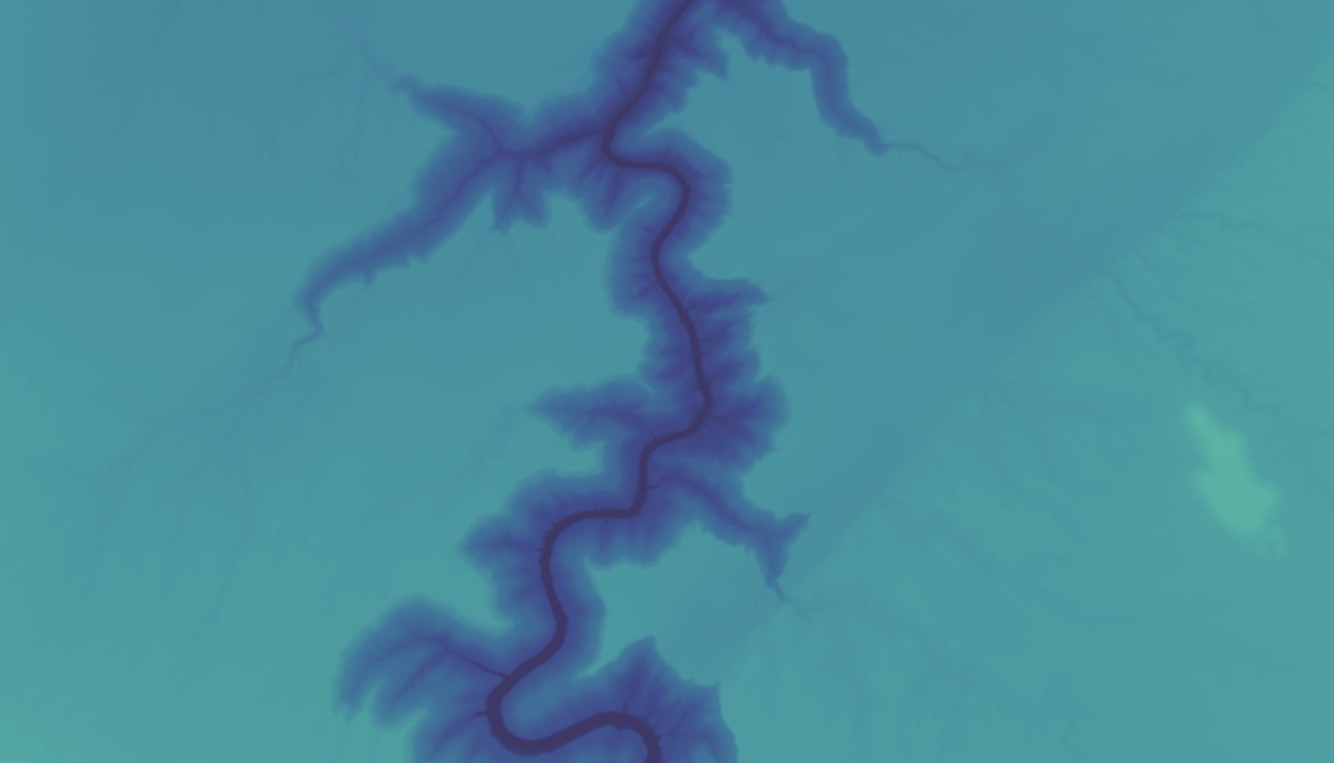
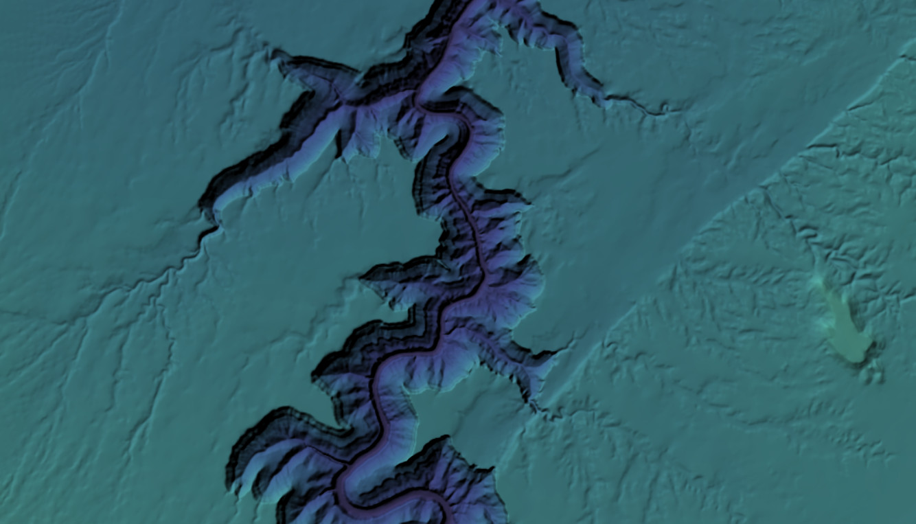
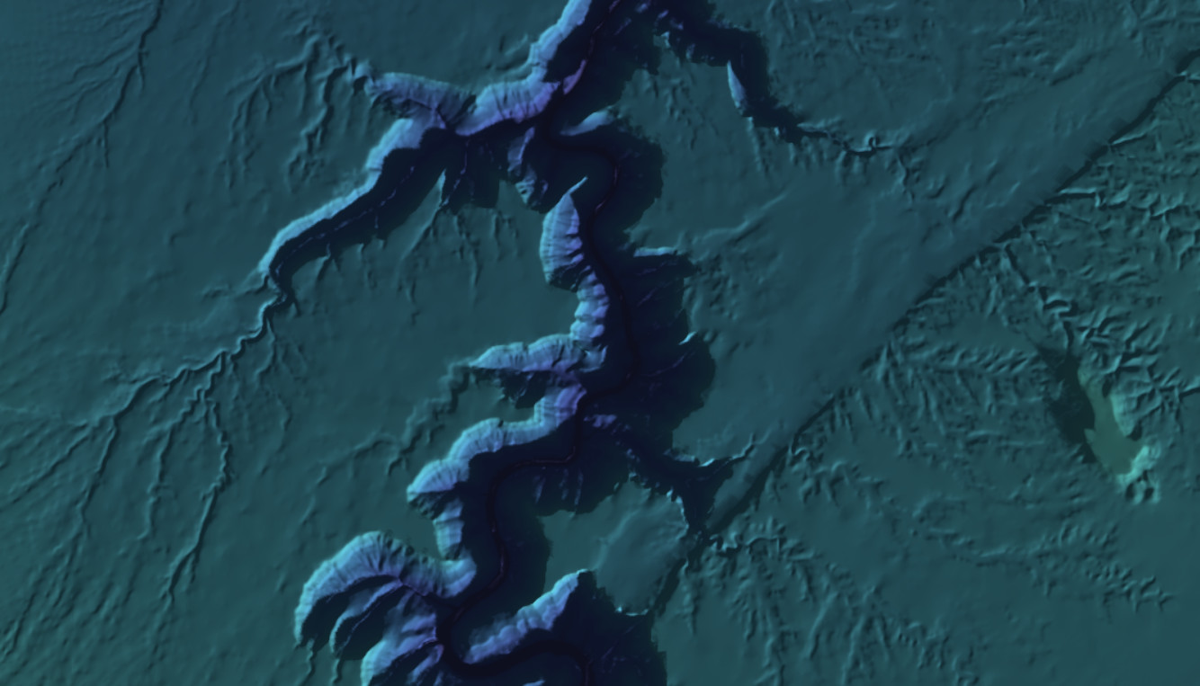
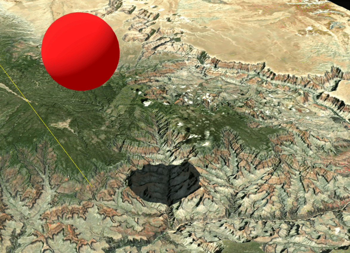
ConclusionLe support complet de l’éclairage three.js pour l’entité Map s’inscrit dans la philosophie de Giro3D de s’intégrer de façon aussi transparente que possible à l’écosystème three.js.
Les ombres portées représentent une addition intéressante pour améliorer la qualité visuelle des scènes et aider à la prise de décision lors des analyses d’ensoleillement.
Vous retrouverez toutes les fonctionnalités de Giro3D sur le site web et sur la page d’exemples interactifs.
Si vous souhaitez en savoir plus, intégrer Giro3D dans votre système d’information, utiliser ces fonctionnalités pour de nouveaux usages, n’hésitez pas à contacter notre équipe à infos+3d@oslandia.com ! Nous serons ravis d’échanger avec vous.
-
15:37
geomatico: Geomatico ya es socio de QGIS España
sur Planet OSGeoEn Geomatico creemos firmemente en la colaboración como motor para impulsar la innovación y la excelencia en nuestro sector. Por ello, hemos decidido asociarnos a QGIS España, una organización que comparte nuestra pasión por los sistemas de información geográfica (SIG) y el código abierto. Esta alianza refuerza nuestro compromiso con el uso de herramientas accesibles y de alta calidad para ofrecer soluciones geoespaciales avanzadas a nuestros clientes.
Esta asociación nos permitirá estar más conectados con la comunidad de usuarios y desarrolladores de QGIS en España, lo que abre nuevas oportunidades de aprendizaje, intercambio de conocimientos y participación en iniciativas conjuntas. Estamos convencidos de que trabajar de la mano con QGIS España no solo beneficiará a nuestros proyectos actuales, sino que también contribuirá al desarrollo del ecosistema SIG a nivel nacional.

Nuestra asociación con QGIS España también refleja nuestra visión de contribuir activamente al desarrollo de la tecnología SIG open source en el ámbito nacional. Al formar parte de esta comunidad, no solo apoyamos una herramienta clave en nuestro sector, sino que también fomentamos el avance de soluciones de código abierto que promueven la sostenibilidad y la accesibilidad tecnológica.
-
11:00
Mappery: Florentine Map Window
sur Planet OSGeo
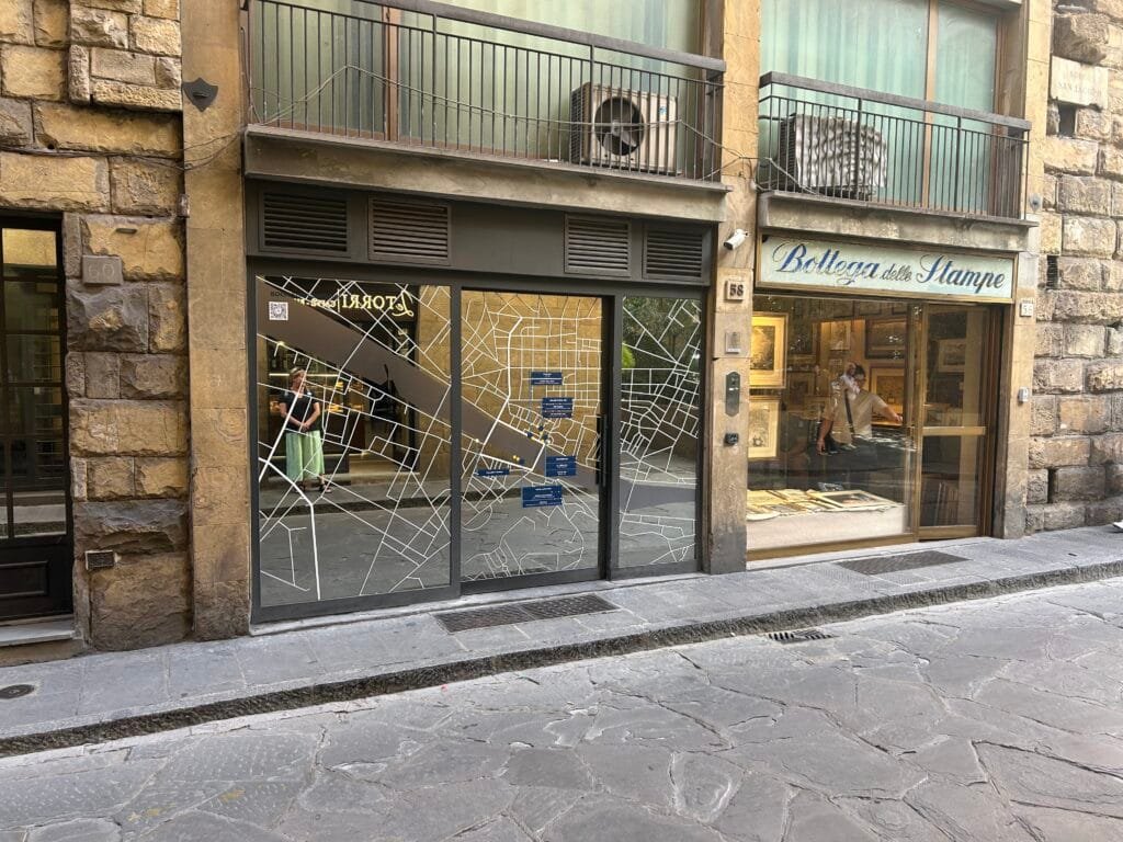
David Sherren said “I spotted this rather attractive office window in the Borgo San Jacopo, Florence, promoting a collection of hotels. As a bonus, there were some nice maps for sale at the print dealer next door.”
I’m a bit confused by some of the writing being on the inside of the window.
-
7:03
OpenSource eXperience – 4 & 5 Décembre 2024
sur Oslandia
Oslandia sera présent à OSXP les 4 et 5 décembre 2024 à Paris. Le salon OpenSource eXperience est la grande rencontre annuelle des acteurs de l’open source.
Retrouvez Vincent et Bertrand sur le stand de notre partenaire et client Orange E14 pour échanger sur vos projets ! Nous pourrons également vous présenter nos dernières réalisations.
Le Groupe Orange a d’abord été utilisateur de produits open source, puis contributeur et éditeur. L’opensource est désormais une direction stratégique du groupe, avec un réel engagement pour être un acteur moteur de l’écosystème. En tant que premier partenaire OpenSource d’Orange, Oslandia est fière d’accompagner ce mouvement !
L’entrée est gratuite, vous pouvez créer votre badge ici : [https:]]
-
12:00
Mappery: At York Station
sur Planet OSGeo
Photo from Doug Greenfield
-
8:18
[Story] Oslandia x QWC : épisode 6 / 8
sur Oslandia
Nous avons détaillé précédemment notre activité de développement fonctionnel autour de QWC, et les ajouts que nous avons pu réaliser. Aujourd’hui, nous évoquons la maintenance !
En plus de ces fonctionnalités, nous sommes confrontés lors des développements ou via des remontées de clients à des anomalies dans QWC. Oslandia réalise donc un travail continu de maintenance corrective sur la solution, pour améliorer sa qualité et sa robustesse.
Nous avons résolu ces dernières années plusieurs problèmes dont:
- l’amélioration du plugin de Ligne de temps (qui permet d’utiliser les données temporelles) où beaucoup de petits problèmes cumulés faisaient crasher l’application
- certains bugs dans la fonctionnalité de recherche
- Divers soucis sur les services QWC ont été corrigés
- problèmes de génération de la configuration
- problèmes de permissions pour l’édition de données
La maintenance des produits OpenSource est un sujet critique, et souvent plus difficile à financer que les développements fonctionnels. Concernant QWC, la maintenance est possible grâce à :
- la collaboration et la mutualisation de la maintenance entre les différents contributeurs ( e.g. SourcePole )
- l’auto-investissement OpenSource d’Oslandia, dont une partie est dédiée à la maintenance des composants clef de nos infrastructure SIG
- les contrats de maintenance QWC attribués à Oslandia
Si vous souhaitez garantir la pérennité de vos applicatifs QGIS web, le meilleur moyen est d’opter pour un contrat de maintenance. Vous aurez ainsi une assurance contre toute mauvaise surprise. Contactez-nous ( infos+qgis@oslandia.com ) !
-
12:00
Mappery: Global incarceration rates
sur Planet OSGeo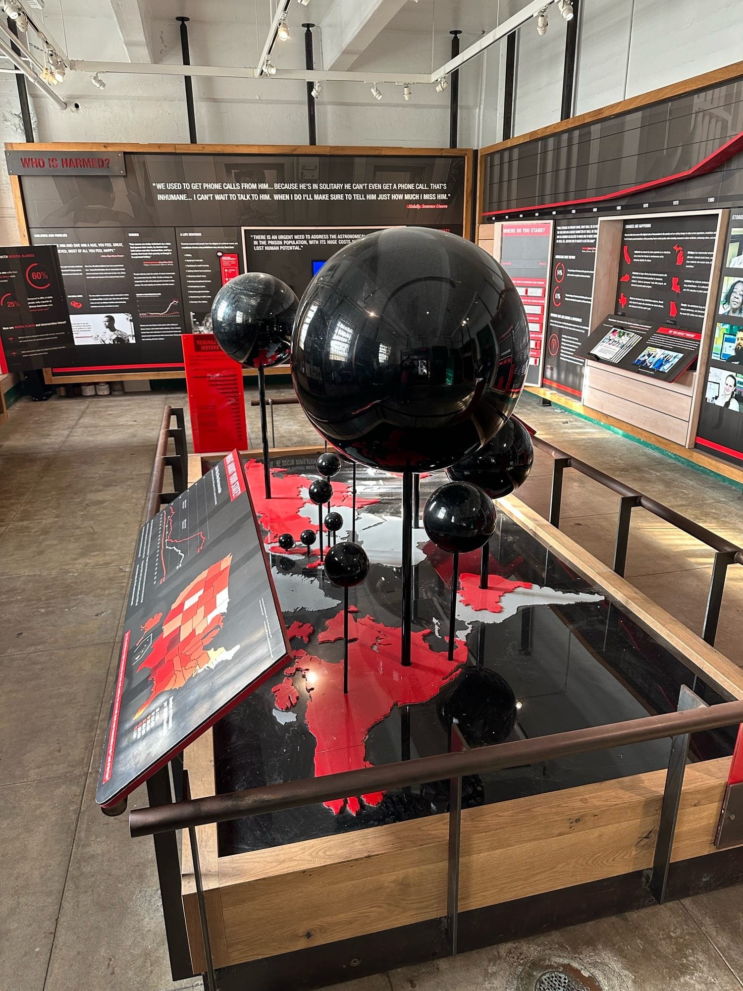

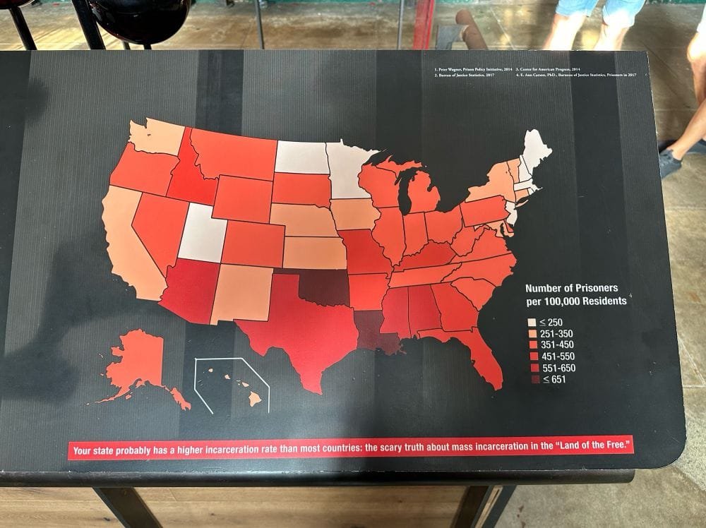
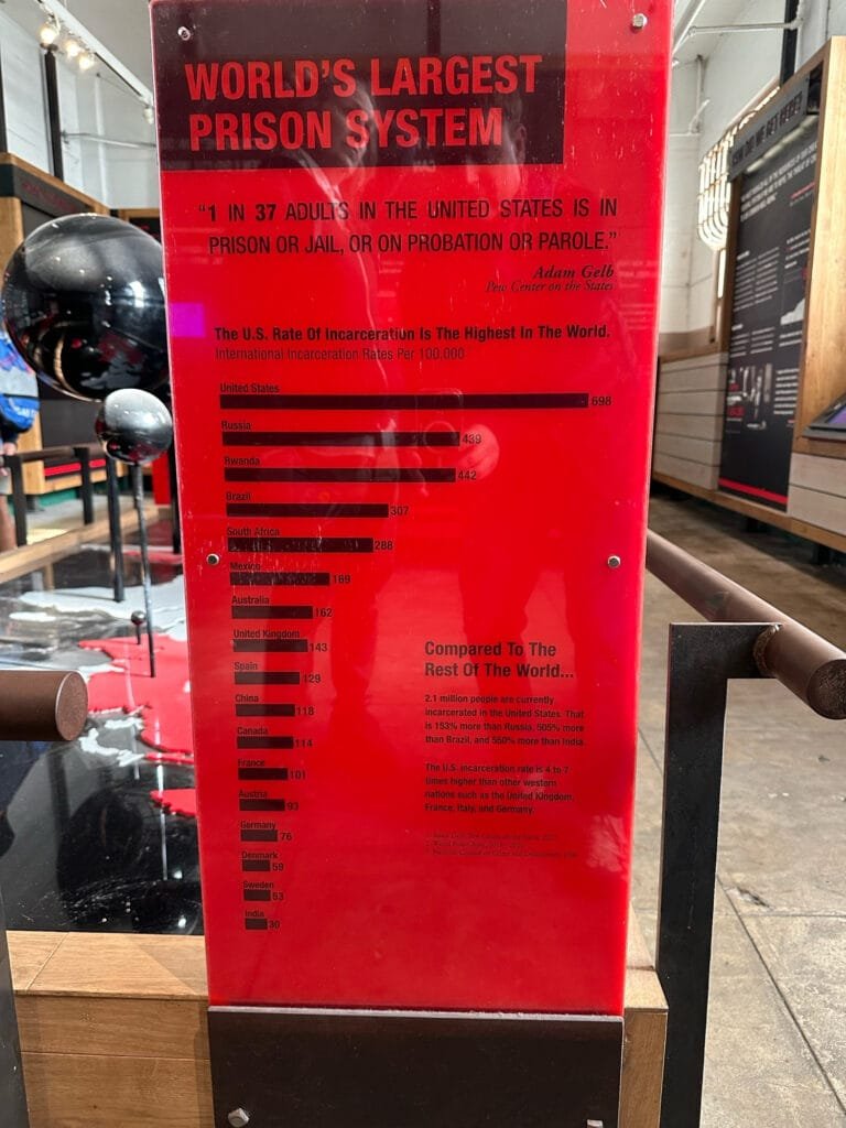
Robert Simmon comments on the Global incarceration rates displayed in Alcatraz: “The Park Service is doing a great job of having a point of view with an almost purely data-driven design”.
-
16:21
From GIS to Remote Sensing: Tutorial: Download Sentinel-2 data and calculate the NDVI in Python using Remotior Sensus
sur Planet OSGeo This post is about Remotior Sensus, a Python package that allows for the processing of remote sensing images and GIS data.In this tutorial we'll see how to search and download Sentinel-2 images and calculate the Normalized Difference Vegetation Index (NDVI) using Remotior Sensus.Following the video of this tutorial.
Read more » -
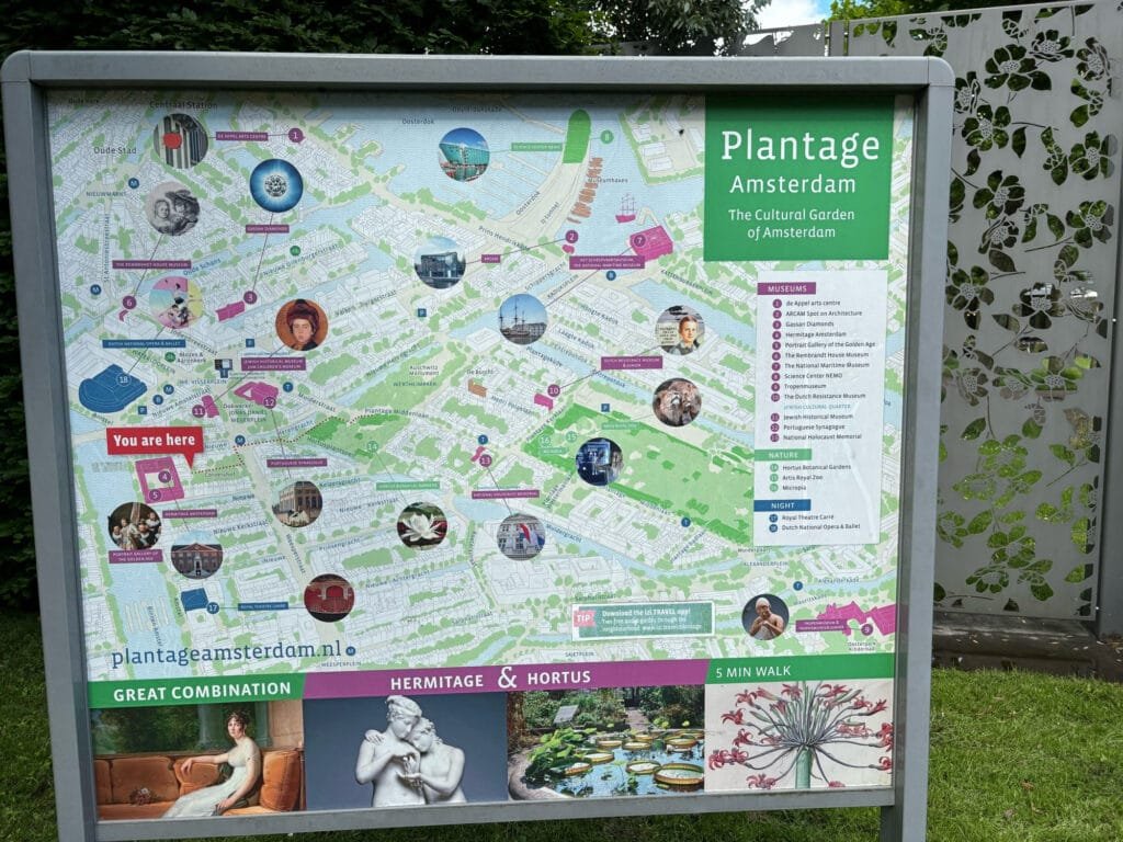
12:00
Mappery: Plantage district Amsterdam
sur Planet OSGeo -
23:23
Free and Open Source GIS Ramblings: GeoParquet in QGIS – smaller & faster files for the win!
sur Planet OSGeotldr; Tired of working with large CSV files? Give GeoParquet a try!
“Parquet is a powerful column-oriented data format, built from the ground up to as a modern alternative to CSV files.” [https:]]
(Geo)Parquet is both smaller and faster than CSV. Additionally, (Geo)Parquet columns are typed. Text, numeric values, dates, geometries retain their data types. GeoParquet also stores CRS information and support in GIS solutions is growing.
I’ll be giving a quick overview using AIS data in GeoPandas 1.0.1 (with pyarrow) and QGIS 3.38 (with GDAL 3.9.2).
File sizeThe example AIS dataset for this demo contains ~10 million rows with 22 columns. I’ve converted the original zipped CSV into GeoPackage and GeoParquet using GeoPandas to illustrate the huge difference in file size: ~470 MB for GeoParquet and zipped CSV, 1.6 GB for CSV, and a whopping 2.6 GB for GeoPackage:
 Reading performance
Pandas and GeoPandas both support selective reading of files, i.e. we can specify the specific columns to be loaded. This does speed up reading, even from CSV files:
Whole file Selected columns CSV 27.9 s 13.1 s Geopackage 2min 12s 
20.2 s GeoParquet 7.2 s 4.1 s Indeed, reading the whole GeoPackage is getting quite painful.
Here’s the code I used for timing the read times:

As you can see, these times include the creation of the GeoPandas.GeoDataFrame.
If we don’t need a GeoDataFrame, we can read the files even faster:
Non-spatial DataFramesGeoParquet files can be read by non-GIS tools, such as Pandas. This makes it easier to collaborate with people who may not be familiar with geospatial data stacks.
And reading plain DataFrames is much faster than creating GeoDataFrames:

But back to GIS …
GeoParquet in QGISIn QGIS, GeoParquet files can be loaded like any other vector layer, thanks to GDAL:

Loading the GeoParquet and GeoPackage files is pretty quick, especially if we zoom into a small region of interest (even though, unfortunately, it doesn’t seem possible to restrict the columns to further speed up loading). Loading the CSV, however, is pretty painful due to the lack of spatial indexing, which becomes apparent very quickly in the direct comparison:
 (You can see how slowly the red CSV points are rendering. I didn’t have the patience to include the whole process in the GIF.)
As far as I can tell, my QGIS 3.38 ‘Grenoble’ does not support writing to or editing of GeoParquet files. So I’m limited to reading GeoParquet for now.
However, seeing how much smaller GeoParquets are compared to GeoPackages (and also faster to write), I hope that we will soon get the option to export to GeoParquet.
For now, I’ll start by converting my large CSV files to GeoParquet using GeoPandas.
More readingIf you’re into GeoJSON and/or PyGeoAPI, check out Joana Simoes’ post: “Navigating GeoParquet: Lessons Learned from the eMOTIONAL Cities Project”
And if you want to see a global dataset example, have a look at Matt Travis’ presentation using Overture data:
-
12:00
Mappery: Upside down
sur Planet OSGeo

Michaël Galien shared this photo of a former globe converted into a lamp, placing the South on top of it

-
12:00
Mappery: Chopping boards
sur Planet OSGeo

Cartonaut saw these chopping boards at Costco
-
12:00
Mappery: Underground at St Pancras
sur Planet OSGeoPièce jointe: [télécharger]

Doug Greenfield shared this map situated in the underground at St Pancras


-
7:48
[Equipe Oslandia] Julien Moura, consultant SIG
sur Oslandia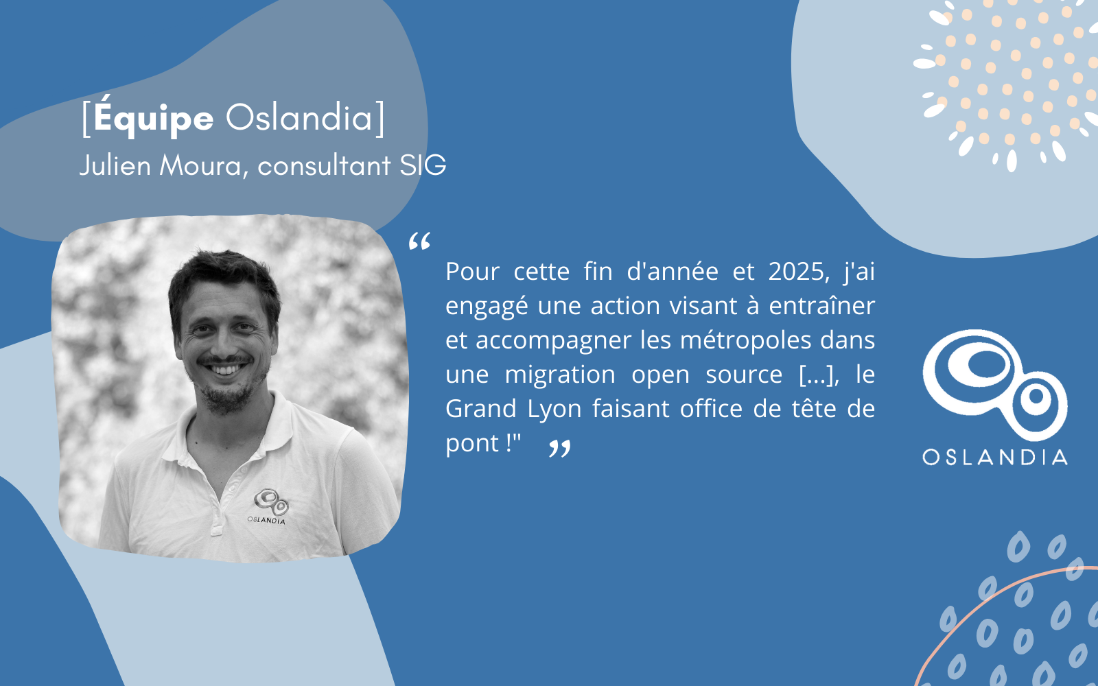
Après son BAC, Julien s’oriente vers une prépa littéraire Khâgne et Hypokhâne au Prytanée national militaire à la Flèche. Il fait ce choix pour profiter de la méthodologie de travail et du challenge qu’offrent la prépa et poursuit son cursus en géographie : Licence de Géographie Urbanisme et Environnement puis le Master parcours Carthagéo à la Sorbonne.
« J’ai depuis toujours associé la géographie au mouvement, et c’est une discipline intéressante qui en croise plein d’autres : environnement, géopolitique, statistiques, mathématiques, … c’est ce qui m’a donné envie de rejoindre cette voie »
Dans le cadre de ses études, il part à Madagascar pour un stage de cartographie prospective sur le traitement et la valorisation des déchets en milieu urbain dense, puis direction La Réunion où Julien est embauché à l’Établissement Public Foncier de la Réunion (EPF Réunion) pour identifier le foncier éligible à des projets d’intérêt général. En parallèle de cet emploi, il s’engage !
« J’aime l’associatif et le partage de connaissances, je commence à donner des cours en géomarketing à l’IAE de la Réunion, je m’investis dans le Club Géomatique de la Réunion pour animer des groupes notamment sur GéoSource (pour INSPIRE), QuantumGIS (l’ancien nom de QGIS) et je rejoins Geotribu ».
Après 3 ans passés à La Réunion, Julien décide de partir du Vénézuela avec son sac à dos comme seul compagnon et parcourt l’Amérique du Sud jusqu’à un coup du hasard dans une gare routière en Équateur où il voit sur GeoRezo une proposition de VIA (Volontariat International en Administration) de l’IRD à Lima !
2 ans plus tard, Julien décide de rentrer en France et reprend des études : le Mastère SILAT – Systèmes d’informations localisées pour l’aménagement des territoires orienté en gestion de projet à Montpellier qu’il réalise en partenariat avec Isogeo, une start-up dédiée à la gouvernance des données géographiques.
Pendant 6 ans, il enchaîne les missions et les postes chez Isogeo : de chef de projet à directeur de produit tout en continuant à contribuer à Geotribu et à donner des cours à l’ESIPE (École supérieure d’ingénieurs de Paris-Est) et l’ENSG, l’école de référence en géomatique en France.
Après une période en indépendant, Julien est embauché chez Oslandia en 2020 en tant que Consultant SIG. Julien est embauché chez Oslandia en 2020 en tant que Consultant SIG.
Projets emblématiques
Très orienté qualité logicielle et DevOps, Julien apporte son expertise sur l’industrialisation de process, des projets de déploiement de QGIS sur des gros parcs, des audits de systèmes complexes et hybrides, recommandations sur les flux de la donnée géographique tout en continuant à donner des cours, notamment à l’École Urbaine de Sciences Po Paris, à animer Geotribu et à s’investir à l’OSGeo FR.« La Géoplateforme de l’IGN où j’ai assuré la coordination interne du projet. Pour cette fin d’année et 2025, j’anime une dynamique action visant à entraîner et accompagner les métropoles dans une migration open source avec comme fenêtre d’opportunité le décomissionnement de la suite Elyx d’une part et le renouvellement des licences ELA Esri d’autre part, le Grand Lyon faisant office de tête de pont. »
Technologies de prédilectionPython et CI/CD (YAML)
Ta philosophieFaire du travail sérieux sans se prendre au sérieux, plutôt que l’inverse !
Oslandia en 1 motOVNI !
-
12:00
Mappery: Florida place mat
sur Planet OSGeo
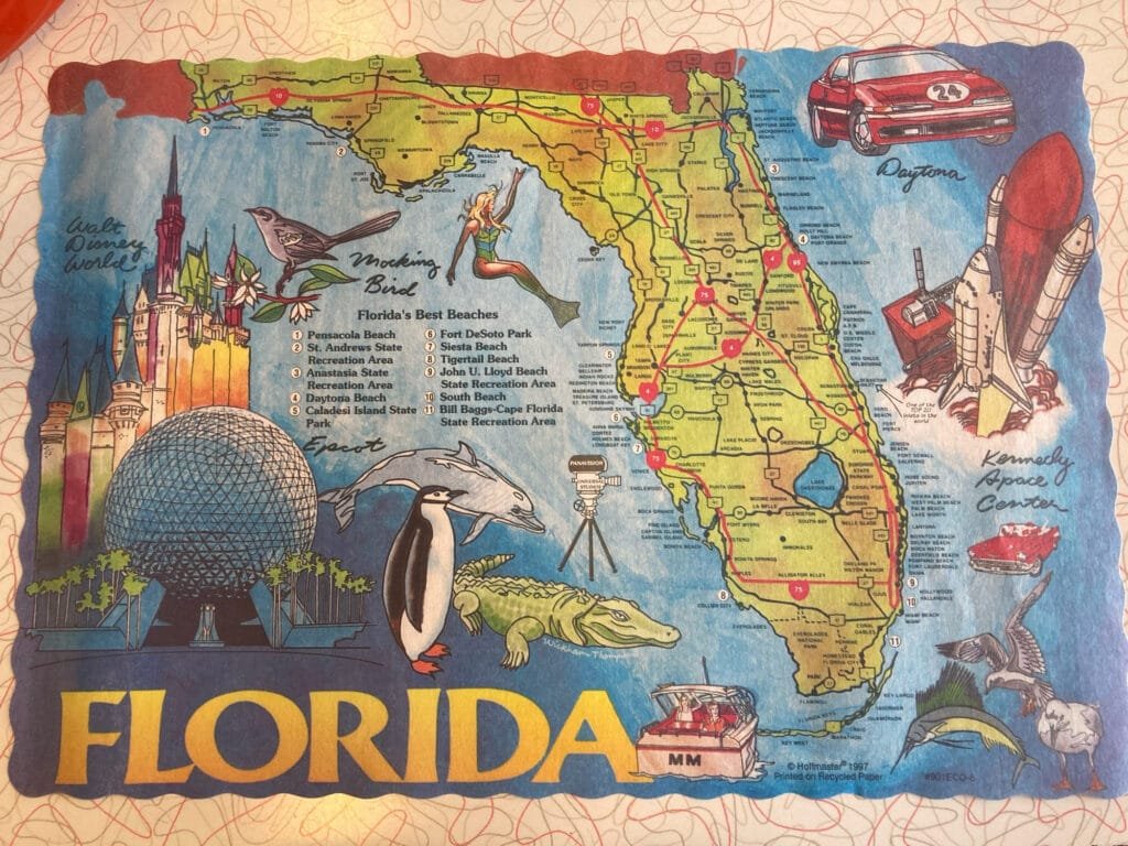
Courtney Shannon shared this place mat
-
23:05
OSGeo Announcements: [OSGeo-Announce] FOSS4G Europe 2024 Tartu final press release
sur Planet OSGeoNews item: FOSS4G Europe 2024 Tartu final press release - OSGeo
November 2024Dear OSGeo community,
it has now been some months since FOSS4G Europe 2024 in Tartu, Estonia.
We, the LOC would like to thank you all for your participation, either on site or via the interwebs, for your proposals for presentations and workshops - you helped us put together this amazing event in our hometown. You've helped us create something that will always have a very special place in our hearts.
The final press-release for FOSS4G Europe 2024 is - finally
 - ready and can be accessed under the foundation news at osgeo.org [1]. Further links to photos, presentation videos on TIB-AV portal and YouTube, and to the academic track proceedings are all in there.
We hope you enjoyed your time in Tartu, and in the surrounding areas if you had time to explore a bit more.
So one last time - on behalf of the FOSS4G Europe 2024 LOC, thank you and see you very soon.
Tõnis Kärdi
FOSS4G Europe 2024 chair[1] - FOSS4G Europe 2024 Tartu final press release - OSGeo
About FOSS4G Europe
--------------------------------
The FOSS4GE conference, a European extension of the Open Source Geospatial Foundation (OSGeo) annual FOSS4G event, connects professionals in the geoinformation software realm. FOSS4G Europe 2024 in Tartu was the eastern and northernmost (and as it turned out - largest) ever FOSS4G Europe conference to date. 2024.europe.foss4g.org
FOSS4G Europe 2024
2024.europe.foss4g.org
FOSS4G Europe 2024
The FOSS4G Europe 2024 conference is taking place 1-7 July in the beautiful city of Tartu, Estonia.
 OSGeo
OSGeo
 FOSS4G (Events) - OSGeo
With a robust schedule of keynote speakers, workshops, paper sessions and talks, FOSS4G offers a great opportunity for newcomers and regular visitors alike. This ‘annual gathering of the tribes’ boasts: A massive selection of presentations A...
Est. reading time: 2 minutes
About OSGeo
-------------------
The Open Source Geospatial Foundation (OSGeo) is a non-profit
organization dedicated to the development and promotion of open-source
geospatial technologies and data. OSGeo serves as an umbrella
organization for the collaborative development of open source
geospatial software, and provides financial, organizational, and legal
support to the broader geospatial community.
OSGeo
OSGeo - OSGeo
OSGeo, the OpenSource for GeoSpatial Fosters global adoption of open geospatial technology by being an inclusive software foundation.
_______________________________________________
Announce mailing list
Announce@lists.osgeo.org
[https:]]1 post - 1 participant
-
21:53
GeoTools Team: GeoTools 32.1 released
sur Planet OSGeoGeoTools 32.1 released The GeoTools team is pleased to announce the release of the latest stable version of GeoTools 32.1: geotools-32.1-bin.zip geotools-32.1-doc.zip geotools-32.1-userguide.zip geotools-32.1-project.zip This release is also available from the OSGeo Maven Repository and is made in conjunction with GeoServer 2.26.1 and GeoWebCache 1.26.1. -
21:51
OSGeo Announcements: [OSGeo-Announce] Welcoming our new OSGeo Charter Members 2024
sur Planet OSGeoNews item: Welcoming our new OSGeo Charter Members 2024 - OSGeo
November 2024OSGeo would like to welcome our new OSGeo Charter Members 2024.
We are happy to announce that the following people were accepted as OSGeo Charter Members:
Alberto Vavassori from Italy
Caitlin Haedrich from United States of America
Cholena Smart from Australia
Claudio Iacopino from Italy
Dave Barter from United Kingdom
Felipe Matas from Chile
Gresa Neziri from Kosovo
Hamidreza Ostadabbas from Iran
Mathieu Pellerin from Cambodia
Matthias Daues from Germany
Maxime Collombin from Switzerland
Petr Sevcik from Czech Republic
Ponciano da Costa de Jesus from Timor-Leste
Sami Mäkinen from Finland
Scott McHale from Canada
Tobias Wendorff from Germany
Vasil Yordanov from Bulgaria
Vincent Sarago from France
William Dollins from United States of America
Youssef Harby from EgyptYou are welcome to find out about our new members at the following page New Member Nominations 2024 - OSGeo
In 2024, we had 21 valid nominations and all were accepted.
This year 300 charter members casted their vote.
The board approved the new members in November 2024.OSGeo has 580 charter members
- from 74 countries
- 11 are retiredThanks a lot to Luís Moreira de Sousa, Iván Sánchez Ortega, Vicky Vergara (2024 OSGeo Elections CROs) for organizing the OSGeo Election 2024.
Share thisSee the full list of the OSGeo Charters member and find a link to every profile page there [https:]]
About OSGeo
-------------------
The Open Source Geospatial Foundation (OSGeo) is a non-profit
organization dedicated to the development and promotion of open-source
geospatial technologies and data. OSGeo serves as an umbrella
organization for the collaborative development of open source
geospatial software, and provides financial, organizational, and legal
support to the broader geospatial community.
OSGeo
OSGeo - OSGeo
OSGeo, the OpenSource for GeoSpatial Fosters global adoption of open geospatial technology by being an inclusive software foundation.
_______________________________________________
Announce mailing list
Announce@lists.osgeo.org
[https:]]1 post - 1 participant
-
12:09
GeoSolutions: FREE Webinar: MapStore at work, NORDIQ webgis product
sur Planet OSGeoYou must be logged into the site to view this content.
-
12:00
Mappery: Traveling seeds
sur Planet OSGeo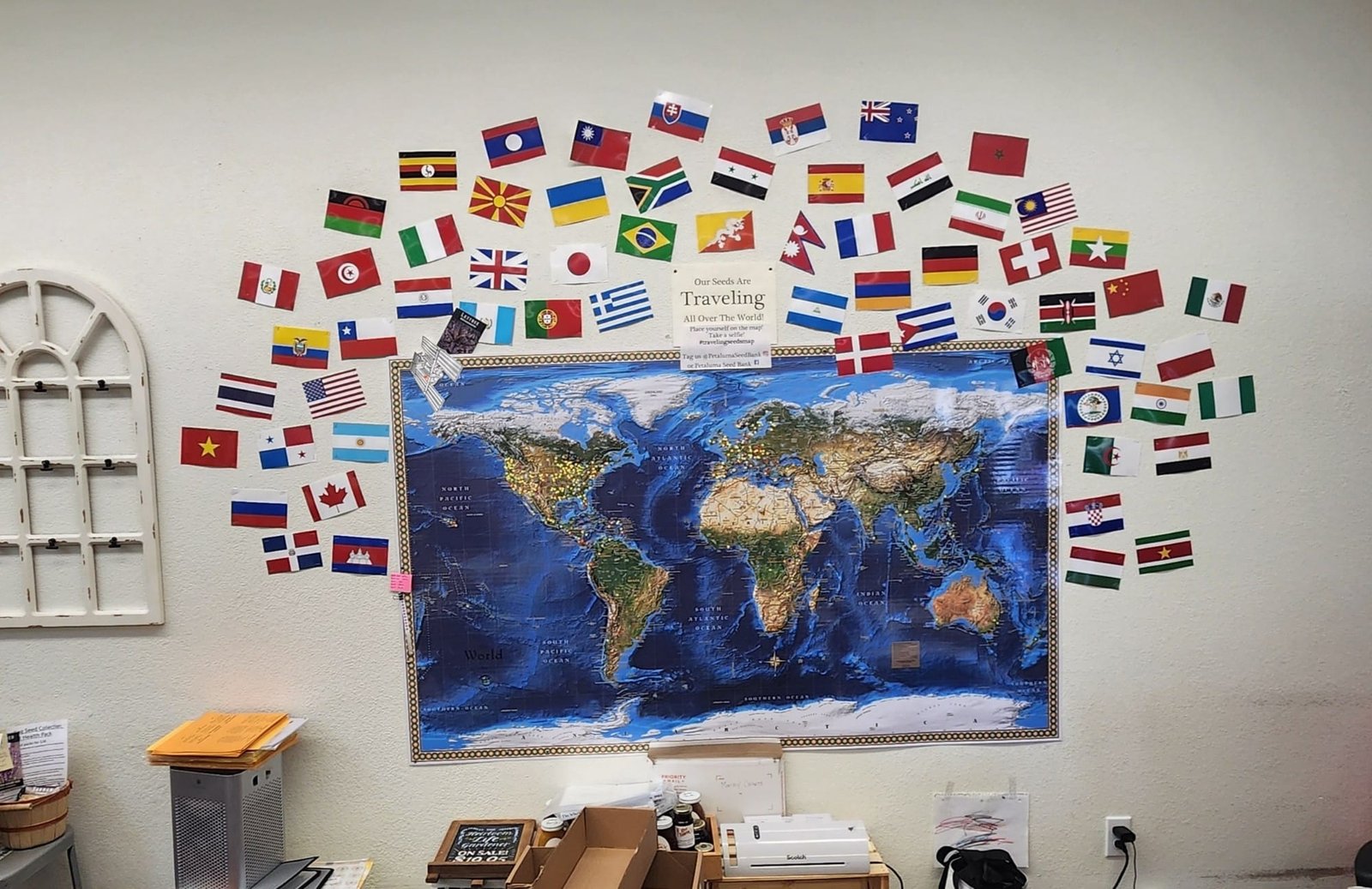
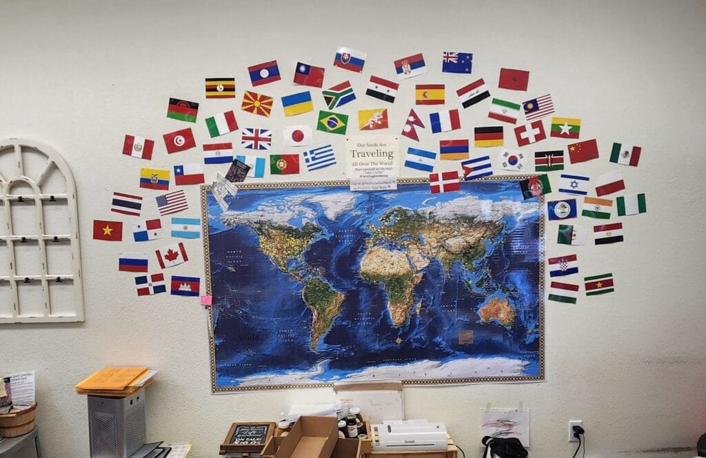
Seed store map of where they ship their heirloom seed. Source: Cartonaut
-
8:10
Ajout du support de géométries 3D complexes dans QGIS 3.40
sur Oslandia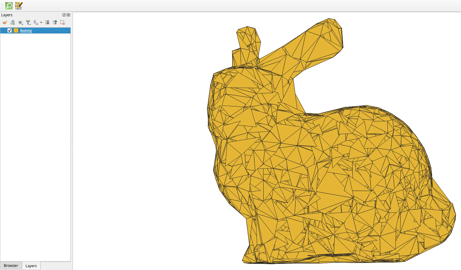
[Un PolyhedralSurface de la forme d’un lapin dans le canvas 2D de QGIS]
Initialement conçu pour la cartographie 2D, QGIS a vu apparaitre des capacités 3D ces dernières années. Suite aux efforts continus de développement portés par Oslandia depuis 3 ans sur cette composante de l’application, QGIS supporte désormais dans sa version 3.40 l’affichage et la manipulation de géométries 3D complètes, comme les surfaces polyhédrales et les réseaux triangulés irréguliers (TIN). Cela permet de visualiser des formes en 3D bien plus réalistes et complexes que de simples polygones.
Pour mieux comprendre, voici une définition simple de ces géométries :
- Une surface polyhédrale est une surface 3D composée de multiples facettes planes (des polygones ou des triangles) qui sont assemblées pour créer une forme en volume, avec un rendu réaliste de courbes et de reliefs.
- Un réseau triangulé irrégulier (TIN) est une surface polyhédrale dont le maillage est constitué exclusivement de triangles de taille et d’angle variables.
Ce nouveau support offre désormais la possibilité d’effectuer des traitements 3D (comme découper, fusionner, déplacer, etc.) via le plugin QSFCGAL. Ces avancées élargissent les perspectives pour les projets nécessitant une analyse 3D.
Ces développements ont été rendus possible grâce au financement du CEA ainsi qu’à nos travaux de R&D financés par l’Union européenne – Next Generation EU dans le cadre du plan France Relance et du projet Cloud Platform for Smart Cities.
Ces évolutions permettent ainsi de répondre aux besoins concrets de nos clients, par exemple en représentant des couches géologiques et en permettant de réaliser des coupes afin de connaitre la nature du sous-sol.
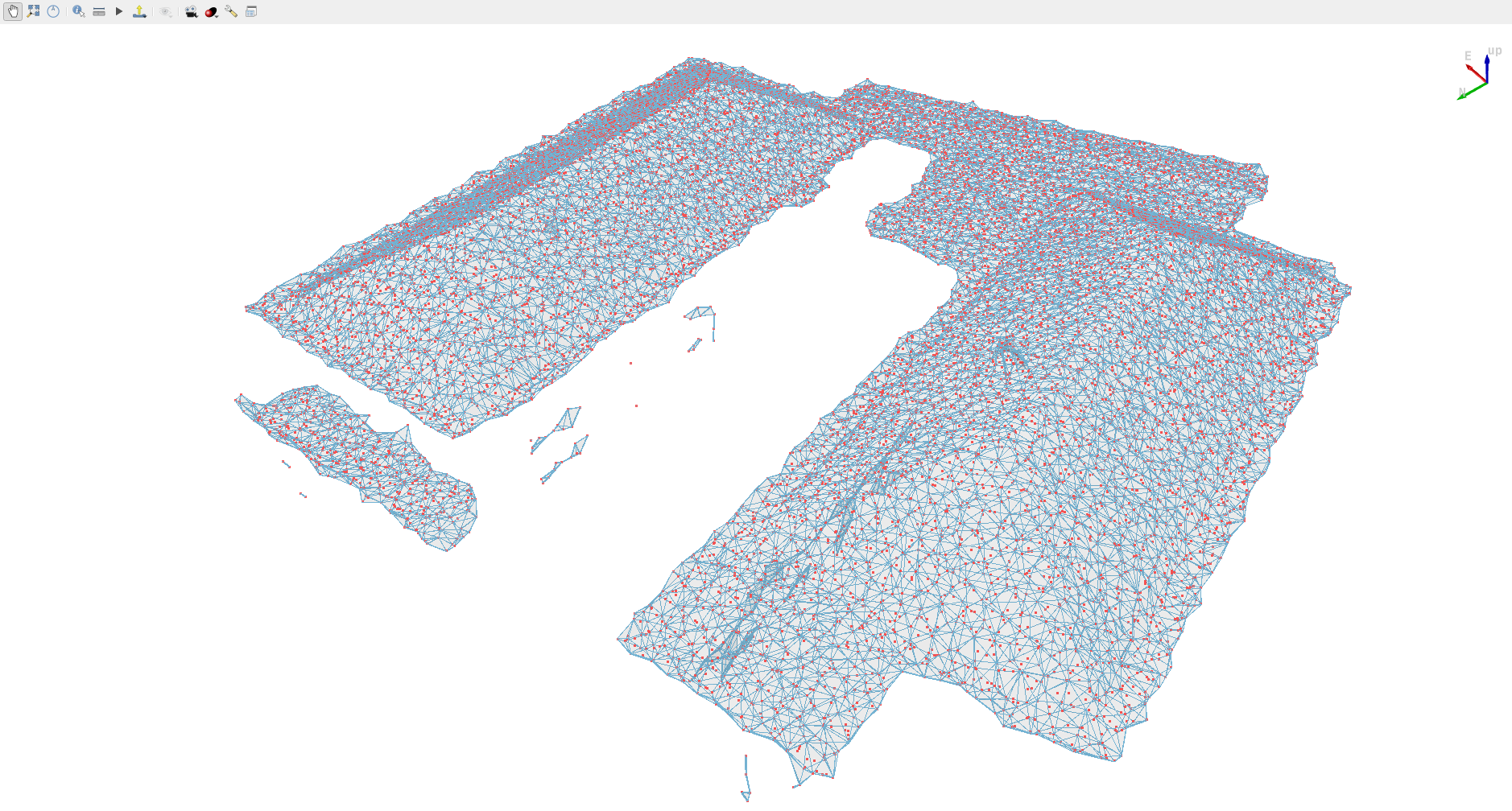
Des PolyhedralSurface visualisés dans QGIS 3D. En rouge, un nuage de points. La géométrie représente une enveloppe concave du nuage de points calculé grâce à SFCGAL.
Si vous êtes intéressés par le rendu ou la manipulation de données 3D dans QGIS, n’hésitez pas à nous contacter !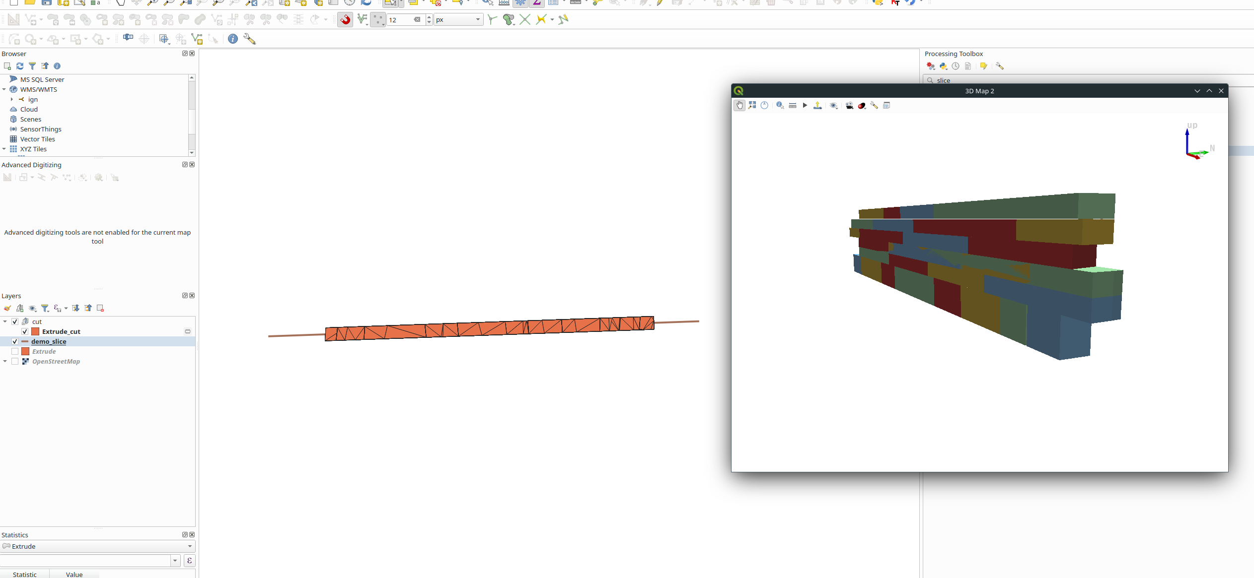 Extraction d’une section d’une géométrie 3D grâce au plugin QSFCGAL
-
12:00
Mappery: Stepney City Farm
sur Planet OSGeo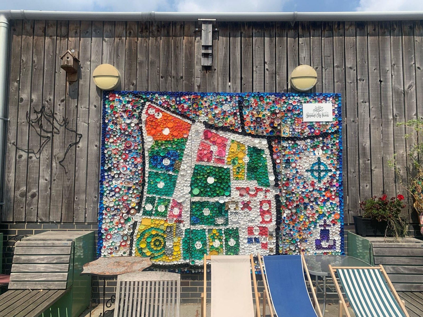

Source: The Geospatial Index
-
4:16
Sean Gillies: Python typing mulligan
sur Planet OSGeoThis is why I've been hesitant to add type hints to Fiona, Rasterio, and Shapely. David Lord on missteps and misgivings:
I want a "start over" tool for type annotating a Python library. I started with Flask as untyped code, then added annotations until mypy stopped complaining. But this didn't mean the annotations were _correct_. Over time I've fixed various reported issues. I feel like if I could start from scratch again, I'd probably get closer to correct with the experience I've gained. But removing all existing annotations and ignores is too time consuming on its own. #python
-
2:00
GeoServer Team: GeoServer 2.26.1 Release
sur Planet OSGeoGeoServer 2.26.1 release is now available with downloads (bin, war, windows), along with docs and extensions.
This is a stable release of GeoServer recommended for production use. GeoServer 2.26.1 is made in conjunction with GeoTools 32.1, and GeoWebCache 1.26.1.
Thanks to Peter Smythe (AfriGIS) for making this release.
Security ConsiderationsThis release addresses security vulnerabilities and is considered an important upgrade for production systems.
- GEOS-11557 CVE-2024-45748 High. The details will be released later.
See project security policy for more information on how security vulnerabilities are managed.
Release notesImprovement:
- GEOS-11557 CVE-2024-45748 High
- GEOS-11561 Client-Delegating MapML Proxy
- GEOS-11588 GWC disk quota, check JDBC connection pool validation query
Bug:
- GEOS-11524 csw: default queryables mapping not generated
- GEOS-11543 Unable to use propertyName to filter properties in a GetFeature request when service is not set
- GEOS-11553 SLD Style: Empty SE Rotationelement throws RuntimeException (QGIS generated SLD)
- GEOS-11556 NullPointerException when GWC disk quota monitoring is disabled
- GEOS-11559 The customized attributes editor is prone to setting the wrong attribute source
- GEOS-11573 TileLayer preview doesn’t work anymore
Task:
- GEOS-11574 Bump org.eclipse.jetty:jetty-server from 9.4.52.v20230823 to 9.4.55.v20240627 in /src
- GEOS-11587 Update map fish-print-v2 2.3.2 - see new MAPFISH_PDF_FOLDER configuration option
- GEOS-11609 Bump XStream from 1.4.20 to 1.4.21
- GEOS-11610 Update Jetty from 9.4.55.v20240627 to 9.4.56.v20240826
For the complete list see 2.26.1 release notes.
Community UpdatesCommunity module development:
- GEOS-11107 Open search for EO community module: packaging missing gt-cql-json-xx.x.jar
- GEOS-11517 Using various OGC APIs results in service enabled check related WARN logs
- GEOS-11560 OGC API modules lack cql2-json in assembly
- GEOS-11563 Allow configuring a DGGS resolution offset on a layer basis
- GEOS-11565 Allow configuring the minimum and maximum DGGS resolution for a layer
- GEOS-11579 DGGS modules prevent GeoServer startup if JEP is not installed
Community modules are shared as source code to encourage collaboration. If a topic being explored is of interest to you, please contact the module developer to make contact and offer assistance, even if it is just to say that it works for you.
About GeoServer 2.26 SeriesAdditional information on GeoServer 2.26 series:
-
14:57
From GIS to Remote Sensing: Tutorial: Create a Sentinel-2 high resolution jpg image Using Remotior Sensus
sur Planet OSGeoThis is a tutorial about Remotior Sensus, a Python package that allows for the processing of remote sensing images and GIS data.In particular, this tutorial illustrates how to create a high resolution jpg image from a Sentinel-2 image. Of course, this tutorial could be extended to other satellite images such as Landsat.Following the video of this tutorial.
Read more » -
12:00
Mappery: Hank’s chalk map
sur Planet OSGeo
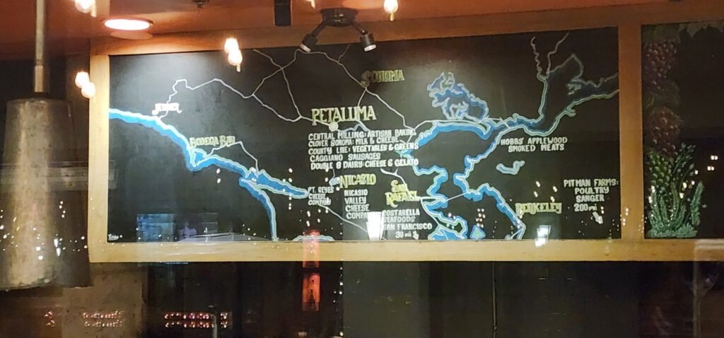
An enthusiastic chalk map on the menu board at Hank’s. Source: Cartonaut
-
14:20
From GIS to Remote Sensing: Semi-Automatic Classification Plugin major update: version 8.5
sur Planet OSGeo -
12:00
Mappery: New Mexico
sur Planet OSGeo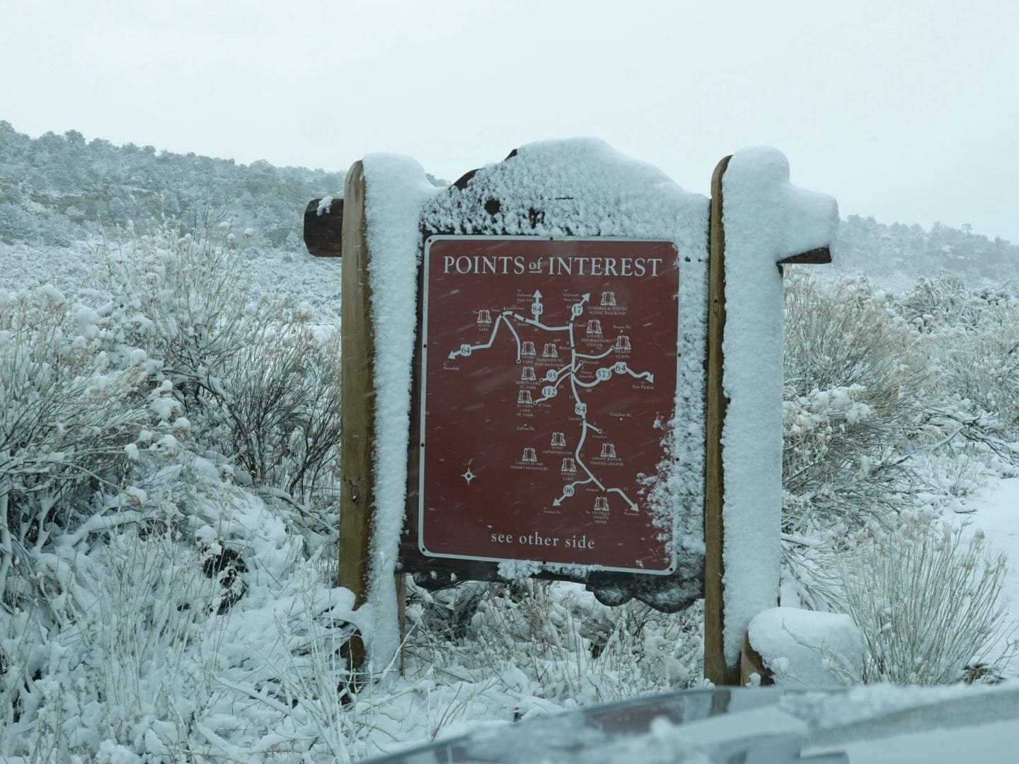

Jami wrote New Mexico has a lot of Maps In The Wild
-
21:36
gvSIG Batoví: Finalizó el VII Curso–Concurso Geoalfabetización mediante la utilización de Tecnologías de la Información Geográfica
sur Planet OSGeo
Un año más de excelentes proyectos desarrollados por estudiantes de todo el país que han decidido animarse y experimentar con el uso de las Tecnologías de Información Geográfica. Y una vez más estos estudiantes nos sorprenden con el nivel y la calidad de sus trabajos, logrados en apenas 3 meses, debiendo además atender todas sus otras responsabilidades que el estudio les exige.

Ya son más de 1000 docentes y estudiantes (no sólo de Uruguay, sino que también de México -en 2022- y Colombia -en 2023-) que han participado de esta iniciativa que nació en 2017 y que se realiza anualmente desde entonces, solamente interrumpiéndose en 2020, especialmente por la pandemia del COVID-19.

Este año nos acompañaron como tutores de los equipos concursantes:
- Romel Vázquez, Universidad Central «Marta Abreu» de Las Villas (Cuba)
- Ramon Alejandro Claro Torres, Universidad Central «Marta Abreu» de Las Villas (Cuba)
- Williams Luis Morales Moya, Universidad Central «Marta Abreu» de Las Villas (Cuba)
- Neftalí Sillero, Faculdade de Ciências da Universidade do Porto (Portugal)
- Carlos Lara, Facultad de Ciencias de la Universidad Católica de la Santísima Concepción (Chile)
- A/P Nadia Chaer, Comunidad gvSIG Uruguay (Uruguay)
- Lic. Maximiliano Olivera, profesor de Geografìa, CeRP del Litoral (Uruguay)
- Antoni Pérez Navarro, profesor de los Estudios de Informática, Multimedia y Telecomunicación, Universitat Oberta de Catalunya (España)
- Agustín Reyna, Dirección Nacional de Topografía (Uruguay)
El jurado estuvo integrado por:
- por el Ministerio de Transporte y Obras Públicas: Arq. Sergio Acosta y Lara
- por la Dirección General de Educación Secundaria: Insp. Mónica Canaveris
- por Ceibal: Mag. Lic. Sofía García
- por la Dirección de Educación Técnico Profesional: Prof. Julio A. Rodríguez
- por la Universidad Politécnica de Madrid: Dr. Luis Manuel Vilches Blázquez
- por la Asociación Nacional de Profesores de Geografía: Prof. Irene Lucía Knecht Santana
- Por la Universidad Central «Marta Abreu» de Las Villas: Dr. Mikel Moreno Hernández
A continuación, los videos de los proyectos ganadores:
Una vez más debemos agradecer a todas y todos los que han hecho posible que esto sucediera: al equipo del MTOP; a las y los tutores; a los integrantes del jurado; a todas y todos los colaboradores en el Plan Ceibal (gracias por su invalorable asistencia); a toda la Asociación gvSIG (gracias a su incansable apoyo es que este proyecto es posible); a la ANEP, en especial a la Dirección General de Educación Secundaria pero también a la Dirección General de Educación Técnico Profesional; a la Universidad Politécnica de Madrid; a las instituciones que este año nos han apoyado: Universidad Central Marta Abreu de Las Villas y la Asociación Nacional de Profesores de Geografía; y a todas las autoridades de las instituciones involucradas que han decidido continuar apoyando esta iniciativa, la que continúa creciendo.
Nos vemos el año que viene
-
12:00
Mappery: Muir Beach
sur Planet OSGeo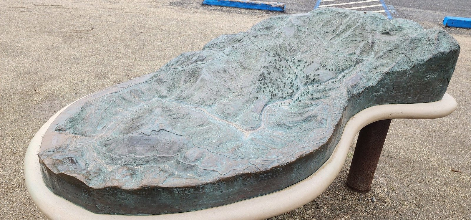
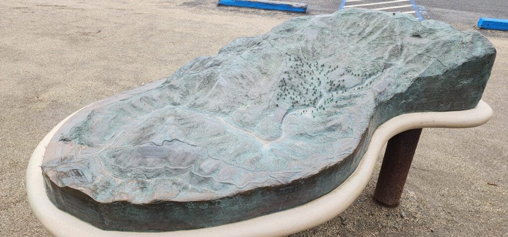
Cartonaut sent us this nice bronze relief and tactile map of Muir Beach.
-
15:10
WhereGroup: Material UI Themes und MapComponents
sur Planet OSGeoMit Material UI und MapComponents lassen sich flexible, ansprechende Kartenanwendungen gestalten. In unserem Blog zeigen wir, wie Themes und individuelle Anpassungen für eine konsistente und benutzerfreundliche Oberfläche sorgen. -
12:25
OSGeo Announcements: [OSGeo-Announce] pgRouting version 3.7.0 release
sur Planet OSGeoThe pgRouting Team is pleased to announce the release of pgRouting version 3.7.0
The latest release is available at [1]
For discussions on the release, go to [2]To see all issues & pull requests closed by this release see the Git closed milestone for 3.7.0 on Github. [3]
*Support*
* #2656 Stop support of PostgreSQL12 on pgrouting v3.7
o Stopping support of PostgreSQL 12
o CI does not test for PostgreSQL 12*New experimental functions*
* Metrics
o pgr_betweennessCentrality*Official function changes*
* #2605 Standarize spanning tree functions output
o Functions:
+ pgr_kruskalDD
+ pgr_kruskalDFS
+ pgr_kruskalBFS
+ pgr_primDD
+ pgr_primDFS
+ pgr_primBFS
o Standarizing output columns to (seq, depth, start_vid, pred,
node, edge, cost, agg_cost)
+ Added pred result columns.*Experimental promoted to proposed*
* #2635 pgr_LineGraph ignores directed flag and use negative values
for identifiers.
o pgr_lineGraph
+ Promoted to proposed signature.
+ Works for directed and undirected graphs.*Code enhancement*
* #2599 Driving distance cleanup
* #2607 Read postgresql data on C++
* #2614 Clang tidy does not work*To update your database*
Download the packaged version from your operating system, and use this command in the database:
ALTER EXTENSION pgrouting UPDATE TO "3.7.0";[1]. Release v3.7.0 · pgRouting/pgrouting · GitHub
[2]. v3.7.0 · pgRouting/pgrouting · Discussion #2677 · GitHub
[3]. Issues · pgRouting/pgrouting · GitHub1 post - 1 participant
-
11:00
Mappery: Walking on London
sur Planet OSGeoPièce jointe: [télécharger]

Joe shared this from his visit to the old City Hall in London “he map room in the lowest floor of the old city hall was pretty big”
-
11:00
Mappery: Cambridge Station Cycle Park
sur Planet OSGeo


The Cambridge Station cycle park has its perk for map lover coming home by night
-
4:16
Sean Gillies: Let's fucking go
sur Planet OSGeoI saw a physical therapist yesterday. I had a virtual visit with my physician today. I had a 2 mile hike in the sun around a local reservoir. Now I'm listening to the Glenn Branca Orchestra on The Frow Show and my take on my health is: let's go!
The expert consensus is that I did not injure my spine, but that muscles in the left side of my hip have clamped down on a nerve. I'm going to proceed as if that is true, foam rolling, walking, and running through the pain, and not worrying about my spine cracking in pieces. I do have a little bit of numbness in my upper left leg and so I will not directly dive into long technical downhill runs. I expect that I'll resolve that soon.
-
15:46
Jackie Ng: Announcing: mapguide-rest 1.0 RC6.1
sur Planet OSGeoI've taken a momentary break from our (admittedly) glacial pace of MapGuide development to put out another release of mapguide-rest
This release includes the following changes:
- Fix missing reverse routing on selection overview
- Fix bad feature query preparation when querying against watermarked layers
- Relax strict-typing on MgReaderToGeoJsonWriter::FeatureToGeoJson() so that it can work with MgPaginatedFeatureReader allowing pagination to work again
- Added missing properties parameter to swagger defn for session-based feature selection route
We now return to regularly-scheduled programming of trying to get MapGuide Open Source 4.0 to the finish line.
As for mapguide-rest, I envision at least once more major RC *after* the final release of MapGuide Open Source 4.0 before finally wrapping things up on development work and pulling the trigger on the mapguide-rest 1.0 final release. Enough of this RC-after-RC business! -
11:00
Mappery: Relief map of Ilhabela
sur Planet OSGeo

Harry shared this map that he spotted on his holiday in Brazil “I also saw this nice wall in a restaurant on Ilhabella which maybe scores better on the “maps as art” criteria.”
I like the way that the land is cut out of the plaster exposing the brick.
-
2:00
Nick Bearman: FOSS4G:UK South West 2024 - Bristol
sur Planet OSGeoIt was great to attend FOSS4G:UK South West 2024 in Bristol on 12th Nov, at OSGeo:UK’s now regular Bristol Venue, The Engine Shed. The event was a sell out and we had 62 people in the Engine Shed’s main room.
This was the first time in a while that I have been to a FOSS4G:UK as an attendee rather than as an organiser - and it made a nice difference! We had 14 great presentations, covering a whole range of topics including digitalization of railways, reproducible science, real time vessel monitoring, landscape heritage, open source funding, cloud native web apps and a whole variety of useful open source tools.
Unfortunately I missed the first presentation - thanks Great Western Railways! - but one common theme that cropped up a lot was how social media as a tool for open source projects has changed dramatically. James Milner said that social media used to be a great way to promote his program, Terra Draw, but know he gets no where near the same impact from using social media. It’s now a bit of a big unknown, and I particularly liked how he summarised this:
Interestingly, I sent out a number of social media posts to Twitter (X), Mastodon and LinkedIn, and LinkedIn got the most response, so make of that what you will! Although I think it’s fair to say LinkedIn is not universally loved, as it was memorably described as “Grindr for Business” by Andrew Bailey!
- Twitter (X) 1 retweet, 7 likes
- Mastodon 3 boosts, 3 favorites
- LinkedIn 6 comments, 4 reposts
The presenters have also mastered the use of memes, with Matt Travis hitting home with some of the perils of waiting for large data sets to load:

and of course also

It was also fantastic to get FAIR Open Science and FAIR workflows mentioned in the presentation by Richard Conway & Garin Smith from Telespazio, who are in the process of developing an exploration platform that allows researchers both to share their data, code and their methods in a reproducible form.
I also had the opportunity to speak about GoFundGeo and talk about how OSGeo:UK is funding a range of open source geospatial projects that will have an impact in the UK. Join the OSGeo:UK mailing list or check the website to find out more.
Nick presenting GoFundGeo, thanks to Sam Franklin for the photo
Finally, as ever, it was great to meet new people and network again with old friends at these events. I know of at least one contract opportunity, as well a number of potential ones and also I think some new volunteers for OSGeo:UK!
Thanks very much to all the organisers - Pascal Coulon, Alastair Graham, Sam Franklin, Dan Ormsby, Illya Sparkes-Santos, Ant Scott, as well as everyone who came along and took part.
If you want help or advice on any open source geospatial tool, or are interested in Introductory or Advanced GIS training in QGIS or R, please do contact me.
-
2:00
Camptocamp: The role of Open Source in achieving Digital Sovereignty
sur Planet OSGeoPièce jointe: [télécharger]
In today’s digital world, the need for control over one’s digital ecosystem is more important than ever. -
11:00
Mappery: Large scale mapping
sur Planet OSGeo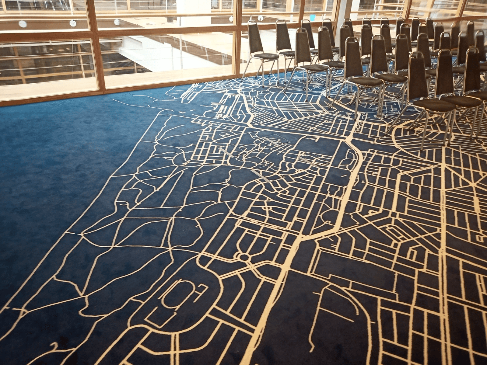

Edwin Wisze shared this “A few of the meeting rooms during the Logius PI planning have a beautiful map as a carpet. Here are a few examples: New York and The Hague”
I love maps you can walk on, feels like the right scale for me.

Which is your favourite?
-
2:00
GeoServer Team: Exploring CQL/ECQL Filtering in GeoServer
sur Planet OSGeoGeoSpatial Techno is a startup focused on geospatial information that is providing e-learning courses to enhance the knowledge of geospatial information users, students, and other startups. The main approach of this startup is providing quality, valid specialized training in the field of geospatial information.
( YouTube | LinkedIn | Facebook | X )
Exploring CQL and ECQL Filtering in GeoServerIn this session, we want to talk about the Using CQL/ECQL Filters in GeoServer in detail. If you want to access the complete tutorial, click on the link.
Introduction
Contextual Query Language (CQL) is a text-based query for search/retrieval adopted by the OGC for the Catalogue Web Services specification. Unlike the XML-based Filter Encoding language, CQL is more readable and easier for manual authoring. However, it has limitations, such as not being able to encode ID filters and requiring the attribute to be on the left side of comparison operators.
To overcome these limitations, GeoServer offers an extended version called ECQL, which closely resembles SQL and provides greater flexibility. ECQL allows users to define filters for querying data in GeoServer using attribute comparisons, logical operators, and spatial predicates. It is compatible with GeoServer’s REST API and can be used for WMS and WFS requests to retrieve filtered data.
Note. This video was recorded on GeoServer 2.22.4, which is not the most up-to-date version. Currently, versions 2.25.x and 2.26.x are supported. To ensure you have the latest release, please visit this link and avoid using older versions of GeoServer.
Note. Future version of GeoServer will include support for CQL2 which provides both a text and a JSON representation.
Comparison operatorsTo compare attribute values or other numeric and text values in your CQL / ECQL (Extended Common Query Language) expressions, you can utilize comparison operators.
In the Layer Preview section, first click on the OpenLayers option for the
topp:stateslayer. Next, locate and click on the Toggle options toolbar in the top left corner to access the advanced options.In the CQL filter box within this toolbar, enter the filter expression
STATE_NAME = 'Texas', and then press the Apply button. This filter will retrieve and display the data for the state of Texas.By reviewing the following examples using the Toggle options toolbar from the LayerPreview page, you will learn how to effectively understand and apply comparison operators using CQL/ECQL expressions:
- ‘PropertyIsGreaterThanOrEqualTo’ filter
This filter shows the states that have more than or equal to 5 million inhabitants.
PERSONS >= 5000000- ‘PropertyIsLike’ filter
This filter shows the states whose names, contain the letters ‘ing’ like Washington and Wyoming.
STATE_NAME like '%ing%'- ‘PropertyIsBetween’ filter
This filter shows the states with a population of 5 million to 10 million.
Spatial operatorsPERSONS between 5000000 and 10000000These operators enable you to perform spatial queries and filter data, based on various relationships between geometries. Here are the explanations for some commonly used spatial operators:
- ‘Intersect’ filter
This filter allows you to query spatial data in GeoServer based on geometric intersection relationships. This filter returns all features that have any spatial intersection or overlap.
The syntax for the Intersect filter in CQL is as follows:
Intersects(the_geom,Point(-90 40))- ‘Within’ filter
The Within filter checks if a spatial object is completely within another spatial object. This filter retrieves all features that are located within the boundaries of a specified geometric shape, using spatial relationships.
Within(the_geom,Polygon((-100 30,-100 45,-80 45,-80 30,-100 30)))- ‘Contains’ filter
This filter is the inverse of the “Within” filter. It checks if a spatial object completely contains another spatial object and helps you retrieve features that fully enclose the specified geometry.
Bounding Box operatorsCONTAINS(the_geom,LINESTRING(-73.9 43.5,-77.76 42.56))The Bounding Box operator is used to filter data based on a specified bounding box. The “bbox” filter in CQL allows you to query spatial data in GeoServer based on a bounding box or a rectangular area.
CQL filters can also be utilized with the GET method. To use the bbox filter using the GET method, enter the following code in the URL address bar of your browser:
http://localhost:8080/geoserver/topp/wms?service=WMS&version=1.1.0&request=GetMap&layers=topp:states&bbox=-124.73142200000001,24.955967,-66.969849,49.371735&width=768&height=330&srs=EPSG:4326&format=application/openlayers&CQL_FILTER=BBOX(the_geom,-110,41,-95,45)This filter enables you to retrieve all features that intersect, or are contained within the specified bounding box.
In this session, we took a brief journey through the “CQL filtering in GeoServer”. If you want to access the complete tutorial, click on the link.
-
11:00
Mappery: Map van
sur Planet OSGeo

I found this Map Van on Portobello Road


